

crossbowftw3
-
Posts
1,394 -
Joined
-
Last visited
Content Type
Profiles
Blogs
Forums
American Weather
Media Demo
Store
Gallery
Everything posted by crossbowftw3
-
For that matter what were our ratios for Pi Day? @sferic
-
Correct. It may sneak into Sullivan for a time but probably not a guarantee. Like I said, won’t impact ratios too terribly. I would guess NEPA gets 10-12:1 while we stay closer to 12-14:1.
-
Yep, gonna swing slightly under IMBY but a foot is pretty secure I think. Ratios still good but BGM did mention this in their AFD: Thermally, the models also suggest a nose of warmer air aloft advancing into at least the southeastern portion of our area overnight Wednesday night, yet still below freezing. This may contribute to some riming on ice crystals and thus slightly lower snow-to-liquid ratios. should not impact ratios too much but might create our upper bound at 12-18.
- 3,762 replies
-
- 1
-

-
- heavy snow
- heavy rain
- (and 3 more)
-
Pretty reasonable for us north and west crew, falls in line with @Rjay had earlier. URGENT - WINTER WEATHER MESSAGE National Weather Service Binghamton NY 259 PM EST Tue Dec 15 2020 NYZ055>057-062-PAZ038>040-162000- /O.UPG.KBGM.WS.A.0007.201216T2000Z-201217T1500Z/ /O.EXA.KBGM.WS.W.0005.201216T1800Z-201217T1500Z/ Tioga-Broome-Delaware-Sullivan-Bradford-Susquehanna- Northern Wayne- Including the cities of Owego, Waverly, Binghamton, Delhi, Walton, Monticello, Sayre, Towanda, Hallstead, Montrose, Damascus, and Equinunk 259 PM EST Tue Dec 15 2020 ...WINTER STORM WARNING IN EFFECT FROM 1 PM WEDNESDAY TO 10 AM EST THURSDAY... * WHAT...Heavy snow expected. Total snow accumulations of 9 to 16 inches. * WHERE...In Pennsylvania, Bradford, Susquehanna and Northern Wayne counties. In New York, Tioga, Broome, Delaware and Sullivan counties. * WHEN...From 1 PM Wednesday to 10 AM EST Thursday. * IMPACTS...Travel could be very difficult to impossible. The hazardous conditions will impact the Wednesday evening and Thursday morning commutes. * ADDITIONAL DETAILS...Snowfall rates of 2 inches per hour possible late Wednesday afternoon through Wednesday night. East to northeast winds at 10 to 15 mph with gusts to 25 mph, especially at higher elevations, may cause some blowing snow and isolated power outages.
- 3,762 replies
-
- 1
-
-
- heavy snow
- heavy rain
- (and 3 more)
-
Upstate/Eastern New York
crossbowftw3 replied to BuffaloWeather's topic in Upstate New York/Pennsylvania
Watches upgraded...seems pretty reasonable with the totals. URGENT - WINTER WEATHER MESSAGE National Weather Service Binghamton NY 259 PM EST Tue Dec 15 2020 NYZ055>057-062-PAZ038>040-162000- /O.UPG.KBGM.WS.A.0007.201216T2000Z-201217T1500Z/ /O.EXA.KBGM.WS.W.0005.201216T1800Z-201217T1500Z/ Tioga-Broome-Delaware-Sullivan-Bradford-Susquehanna- Northern Wayne- Including the cities of Owego, Waverly, Binghamton, Delhi, Walton, Monticello, Sayre, Towanda, Hallstead, Montrose, Damascus, and Equinunk 259 PM EST Tue Dec 15 2020 ...WINTER STORM WARNING IN EFFECT FROM 1 PM WEDNESDAY TO 10 AM EST THURSDAY... * WHAT...Heavy snow expected. Total snow accumulations of 9 to 16 inches. * WHERE...In Pennsylvania, Bradford, Susquehanna and Northern Wayne counties. In New York, Tioga, Broome, Delaware and Sullivan counties. * WHEN...From 1 PM Wednesday to 10 AM EST Thursday. * IMPACTS...Travel could be very difficult to impossible. The hazardous conditions will impact the Wednesday evening and Thursday morning commutes. * ADDITIONAL DETAILS...Snowfall rates of 2 inches per hour possible late Wednesday afternoon through Wednesday night. East to northeast winds at 10 to 15 mph with gusts to 25 mph, especially at higher elevations, may cause some blowing snow and isolated power outages. -
BGM still talking between 12 and 14:1 as well. Pretty good I'd say. Helps limit power issues to a nonzero but quite limited factor and will be so much easier to clear. More concerned with areas closer to NYC and on coasts that do snow, paste bomb.
-
what have we got for ratios? Still over 12:1 I assume?
-
Someone across CPA probably steals our jack and gets the 2' but I think we're good to go for 12-18. I don't think gusts get over 30. My point and click for tomorrow night is 10-15 gusts 25. Power issues should be quite limited but nonzero--we can be thankful the ratios will be good here.
-
BGM has kept pretty steady between 12:1-14:1 with their discussions so that makes sense. Temperatures don't break 30 Wednesday daytime and fall to between 17-20 nighttime. All I need to know--good work as always.
- 3,762 replies
-
- 1
-

-
- heavy snow
- heavy rain
- (and 3 more)
-
Walt, What's your best guess on ratios inland? Still between 12-14:1 or even up to 16?
- 3,762 replies
-
- 1
-

-
- heavy snow
- heavy rain
- (and 3 more)
-
Active mid December with multiple event potential
crossbowftw3 replied to Typhoon Tip's topic in New England
Blizzard warnings definitely still do exist and get used. Some were used this past January but in the Upper Midwest. -
As an aside I sometimes love Joe’s ability to prop up the most ridiculous possible outcomes for a storm.
- 3,762 replies
-
- 2
-
-
- heavy snow
- heavy rain
- (and 3 more)
-
Upstate/Eastern New York
crossbowftw3 replied to BuffaloWeather's topic in Upstate New York/Pennsylvania
While I do like this, trends tonight will be very telling. 18z Euro isn't helping. -
0z is going to be huge for us north of 84.
-
Upstate/Eastern New York
crossbowftw3 replied to BuffaloWeather's topic in Upstate New York/Pennsylvania
18z Euro....off hour but nerves beginning in earnest again Went from 10-12 to 6-8 this run. 0z will be huge and very telling for the fates of everyone north of 84.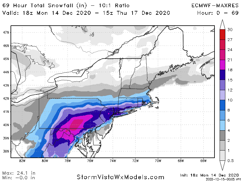
-
Upstate/Eastern New York
crossbowftw3 replied to BuffaloWeather's topic in Upstate New York/Pennsylvania
Fascinating, lmao... This is where the 10 degree dewpoint line likely is. Per @NJwx85 on NYC forum. It's basically over our heads. If models account for this look out.png.4c6ab328c140785001b2669751a9e060.png)
-
30 miles north of 84, and under 10-15 miles from where that line is set up. I have to imagine further adjustments will be made. Still thinking failure mode will be 3-6 or maginal warning.
-
That cutoff is basically right over my head. Not great.
-
If another tick or two happens southeast we will likely end up out of warning amounts. Models finally picking up confluence...as I had always said this had a chance to evolve to a 95 crusher and it's already getting there: will us north of 84 slip out of warning level totals remains to be seen
-
Upstate/Eastern New York
crossbowftw3 replied to BuffaloWeather's topic in Upstate New York/Pennsylvania
That map was probably done with older data. Come later on it'll be different. -
Upstate/Eastern New York
crossbowftw3 replied to BuffaloWeather's topic in Upstate New York/Pennsylvania
The confluence is strong with this one, we could still get smoked in the negative direction but this is still fine: county-wide 6-12 is still good enough for me. We must watch tonight's runs either way. -
Upstate/Eastern New York
crossbowftw3 replied to BuffaloWeather's topic in Upstate New York/Pennsylvania
Fading away. Consensus growing and it's not working out for me nor anyone else here. Can't help but thinking one or two more ticks SE. The fringe, man..thumb.png.dc96f6798ba37fbaec41b2be5358f3e3.png)
-
Upstate/Eastern New York
crossbowftw3 replied to BuffaloWeather's topic in Upstate New York/Pennsylvania
Not a great sign. Sitting at the fringe in setups like these doesn't work out at least half of the time. Going to sweat this one out without a doubt over the next 48 hours.

.png.0f8f63eabd7fbd643249f889c49a276f.png)