

Kmlwx
-
Posts
13,431 -
Joined
-
Last visited
Content Type
Profiles
Blogs
Forums
American Weather
Media Demo
Store
Gallery
Everything posted by Kmlwx
-

2021 Mid-Atlantic Severe Weather - General Discussion
Kmlwx replied to Kmlwx's topic in Mid Atlantic
The GFS has pretty paltry CAPE values for most of the metro area. The NAM looks pretty meh as well - but the NAM nest does send a healthy line through. If it were me at the SPC desk (thank god it isn't) I'd probably trim the hatched area to remove DC proper. Severe weenies near Fredericksburg are seemingly better positioned. -
2021 Mid-Atlantic Severe Weather - General Discussion
Kmlwx replied to Kmlwx's topic in Mid Atlantic
Latest guidance seems to want to get the best activity to the south and east of the DC area. Not surprising - and certainly inline with the overall SPC outlook area. NAM and the nest don't look quite as impressive as they did for the immediate metro area as they did yesterday. -
2021 Mid-Atlantic Severe Weather - General Discussion
Kmlwx replied to Kmlwx's topic in Mid Atlantic
People start paying attention when you pop in. -
2021 Mid-Atlantic Severe Weather - General Discussion
Kmlwx replied to Kmlwx's topic in Mid Atlantic
18z NAM continues to look decent for Sunday. It does look slightly less robust in a few regards - but really it's noise. Seems the potential is still solidly on the table. -
2021 Mid-Atlantic Severe Weather - General Discussion
Kmlwx replied to Kmlwx's topic in Mid Atlantic
LWX mentions next Wednesday as another potential strong thunderstorm threat - but says it could be more of a high shear/low CAPE kind of setup due to timing and limited warm air advection. -
That map is just comical!
-
2021 Mid-Atlantic Severe Weather - General Discussion
Kmlwx replied to Kmlwx's topic in Mid Atlantic
Seems the model biases are always this way. NAM always tends to show bonkers soundings/parameters and GFS is more muted. Could be the first "true" threat of the year - will it also be the first bust? -
2021 Mid-Atlantic Severe Weather - General Discussion
Kmlwx replied to Kmlwx's topic in Mid Atlantic
I was kind of surprised to see the hatching for a D3 outlook. The outlook text reads less like a hatched day and more like a higher end SLGT day. Could just be because it's out in range for now. It looks like the NAM nest focuses the best parameters just to the west of the metro area, the 12k version had it in the immediate metro area and east. It looks like it still has that little meso-low type feature. -
2021 Mid-Atlantic Severe Weather - General Discussion
Kmlwx replied to Kmlwx's topic in Mid Atlantic
The 12z NAM (12km) is kind of insane for Sunday now. It looks like it tries to pop a little low right along the Mason-Dixon line which really ramps up the potential. Supercell composite is very high for Sunday PM for a decent chunk of the area. Remove that little meso-low feature and things maybe aren't as robust. Will be interesting to see what the 3km looks like (at range of course). For March...this has some higher end potential. -
2021 Mid-Atlantic Severe Weather - General Discussion
Kmlwx replied to Kmlwx's topic in Mid Atlantic
Take a look at this frame from the latest SREF on the SPC maps for 18z on Sunday............wow. That's some drool worthy stuff for @yoda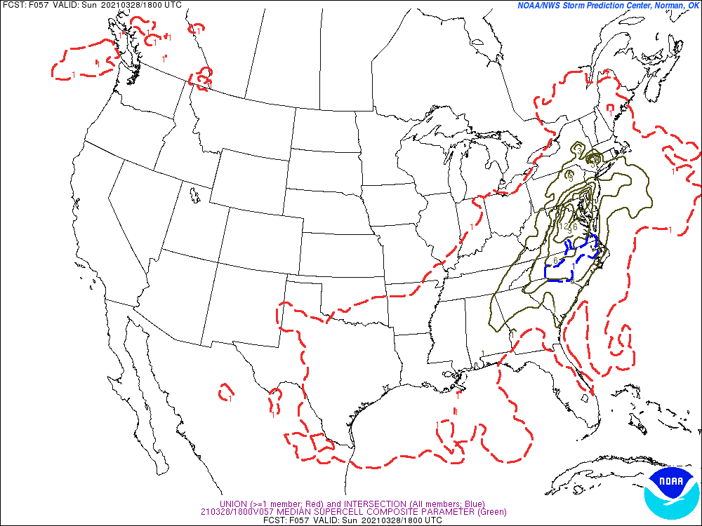
-
2021 Mid-Atlantic Severe Weather - General Discussion
Kmlwx replied to Kmlwx's topic in Mid Atlantic
Yeah the NAM looks pretty decent for Sunday around 18-21z. Let's see if it pans out. We are fringed by the hatching on that SPC outlook...but it's also day 3. -
2021 Mid-Atlantic Severe Weather - General Discussion
Kmlwx replied to Kmlwx's topic in Mid Atlantic
Ummmm - did not expect that -
2021 Mid-Atlantic Severe Weather - General Discussion
Kmlwx replied to Kmlwx's topic in Mid Atlantic
Looks as if we will keep waiting. Not much of anything of interest on the long range GFS either. Not surprised - but we'll see what April brings. -
2021 Mid-Atlantic Severe Weather - General Discussion
Kmlwx replied to Kmlwx's topic in Mid Atlantic
The NAM is too fast for Friday as well. Would be too early in the day to maximize heating. -
2021 Mid-Atlantic Severe Weather - General Discussion
Kmlwx replied to Kmlwx's topic in Mid Atlantic
Worth reminding the less frequent severe posters - it is still VERY early for our severe season. Anything this early is usually bonus gravy (sort of like November accumulating snow). April is even a bit early but can definitely have some beefier setups. May/June can be what either makes or breaks our severe weather season as a whole. -
2021 Mid-Atlantic Severe Weather - General Discussion
Kmlwx replied to Kmlwx's topic in Mid Atlantic
That discussion does a good job of summarizing the potential outcomes. Anything from nothing to some severe weather. Covers all the bases -
2021 Mid-Atlantic Severe Weather - General Discussion
Kmlwx replied to Kmlwx's topic in Mid Atlantic
I'll watch it with one eye for now. Not too shabby for March. -
2021 Mid-Atlantic Severe Weather - General Discussion
Kmlwx replied to Kmlwx's topic in Mid Atlantic
This is the time of year when I start giving CIPS analogs some general glances to see what kinds of threats may be coming down the pike. It's still VERY early for our region. Patience. -
2021 Mid-Atlantic Severe Weather - General Discussion
Kmlwx replied to Kmlwx's topic in Mid Atlantic
So many of our events are razor thin margins with timing or other factor. And 12 hours is often on the higher end of how we bust. Often it's the difference of just like 5-8 hours that kills us. -
2021 Mid-Atlantic Severe Weather - General Discussion
Kmlwx replied to Kmlwx's topic in Mid Atlantic
Hopefully April will start to bring opportunities for us. But often we end up waiting until May/June for the meaty stuff. -
2021 Mid-Atlantic Severe Weather - General Discussion
Kmlwx replied to Kmlwx's topic in Mid Atlantic
That doesn't look terrible for a VERY early season thunderstorm threat. -
Yeah 37 and rain sounds miserable. Well so does 33 and rain - if we can somehow luck our way into a few inches before we sprint into spring, I'm all for it. Didn't mean to come across as argumentative before (if I did). I'm mostly on the same train as you - but I just love pushing back any sustained heat as long as we can. Summer is long enough here!
-
In March. Not in April or other months of course. Bring on the 70s and sun in April without question.
-
March has been a bona fide winter storm month in recent years. And not even like the bold section - like actual accumulation events. If we can luck our way into that - I'd take a few inches of snow (even if it melts quickly) over a 70 degree day.
-
To each their own - but keep the warmth at bay for now. I'd like to keep my A/C on the sidelines for as long as possible. Before you know it it'll be 95 degrees with a 70+ dewpoint. Now if it stays 65-70 and not humid - I'm all for it. Only time heat is acceptable to me is if it comes with interesting weather.

