
Holston_River_Rambler
-
Posts
5,107 -
Joined
-
Last visited
Content Type
Profiles
Blogs
Forums
American Weather
Media Demo
Store
Gallery
Everything posted by Holston_River_Rambler
-
So here's a question, but first an explanation of why I'm asking. Anthony Masiello tweeted an image of the N. Pole yesterday and was writing about the tropospheric vortices forming a "doughnut" around a high at the N. pole. Here's my version of this from the GEFS this AM: https://imgur.com/a/LMxZmqH. This is on the EPS too. Now, Masiello was making a point about the Greenland block and possible repercussions of the evolution of all this in terms of NE snow, but my question is about that high at the north pole. Is this a way to build up some very cold air there? Having a big high just set up there with limited if any sunlight seems like it would create a nice airmass. Obviously no guarantees on where it dumps if it does develop and produce cold. But is that even how any of this works?
- 185 replies
-
- 2
-

-

-
- first freeze
- temps
- (and 2 more)
-
Never seen anything like this before, and the GFS has spit out some weird stuff. Putting it here because I'm not sure it contributes to the overall discussion in the Fall/ Winter threads (more of a what the *&^% is that moment for me), but the whole CONUS in negative 500mb geopotential height anomalies.
-
Even though I think there are still surprises left with the developing blocking and northern stream evolution, one thing keeps showing up, run after run: gulf or southern lows of some variety or another. 4 on this morning's GFS run. Track, temps, precip. all still uncertain, but storms are coming in starting late next week through early Dec.
- 185 replies
-
- 4
-
-
- first freeze
- temps
- (and 2 more)
-
I was so hopeful after Auburn, then again last week after Kentucky. Maybe Florida Atlantic can go 6-6 and we can too. Hey, they just have to beat Charlotte . I feel like if we lose to Kiffin at the end, any sort of a curse might be broken. Lose to Butch, then Dooley, then Kiffin this year and finally the wheels of time are turned back and we get a clean slate in fall 2019?
-
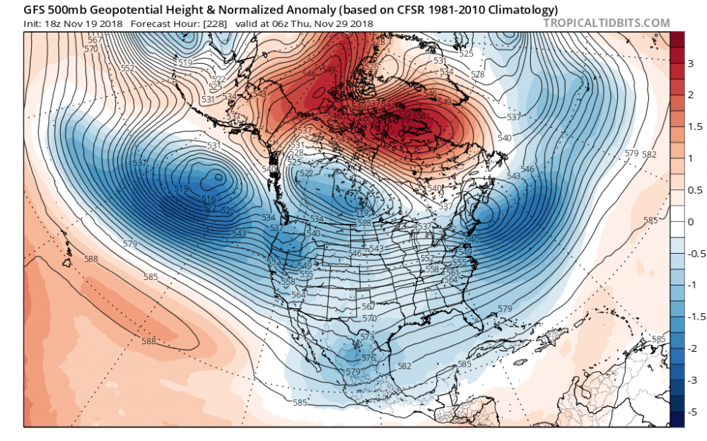
Been trying to figure out what I think of the upcoming pattern/ PNA, AO, NAO. Lots of interest on other regions' discussions in the Dec. 1 or thereabouts time frame and perhaps rightly so. Ensemble means look nice and FV3 has been looking amazing at that time. Just can't quite get fully onboard just yet. Not because I don't think there is change coming or that it will not be great, but because I'm not sure how it plays out. Look how much uncertainty develops as the -NAO develops from the Scandinavian ridge: We go from not horrible disagreement at 500 mb in 140 hours or so, to a real spaghetti mess by hour 186. Apparently this is really messing with the model, although some of this may be normal Plinko/ ensemble progression. But for me this animation really shows how that block starts to choke up traffic and back it up, back it up, back it up. Like a traffic jam, upstream traffic buckles and becomes more convoluted too. I really want to get excited about the teleconnections, but I don't think models start to sharpen focus on what those could produce until the Scandinavian ridge migration is complete and it sets up shop. By the way, this is not meant as a direct response to Jax above. I was just cruising around COD site this AM since Tropical Tidbits is down for server maintenance and noticed the spaghetti plots, something I don't normally look at.
- 185 replies
-
- 4
-
-
-
- first freeze
- temps
- (and 2 more)
-

11/14-15 Early Season Westside Winter Event
Holston_River_Rambler replied to John1122's topic in Tennessee Valley
The results of the upslope snow and rime on Max Patch: The air was so clear! The temp was about 23 with a stout wind. Just a teaser (wish I could upload them all here!). Here are the rest: https://imgur.com/gallery/OUr79E1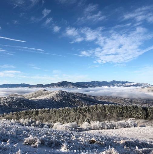
-
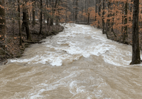
Water levels are high on the plateau. After seeing some Crossville snow (29 and windy), I rambled through Grassy Cove (Grassy Swamp today) to Upper Piney Falls: https://imgur.com/gallery/86E9HqL Hard to appreciate the force of the water without the sound: https://youtu.be/vBng9sYoiVM
- 110 replies
-
- 1
-
-
- fall
- temperatures
- (and 5 more)
-
11/14-15 Early Season Westside Winter Event
Holston_River_Rambler replied to John1122's topic in Tennessee Valley
Snowing in Crossville! Hard to tell from the pic, but I'd say close to moderate given visibility. Individual flakes aren't all that big.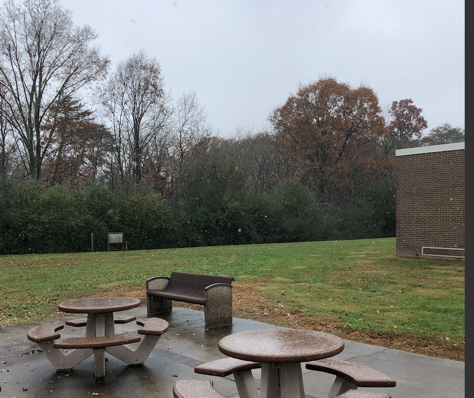
-
11/14-15 Early Season Westside Winter Event
Holston_River_Rambler replied to John1122's topic in Tennessee Valley
Radarscope thinks Wise, VA has switched to snow. Any one up that way? -
11/14-15 Early Season Westside Winter Event
Holston_River_Rambler replied to John1122's topic in Tennessee Valley
I had some reports from friends to day of sleet at onset of precip, in Oak Ridge and Huntsville (Scott Co., TN) -
11/14-15 Early Season Westside Winter Event
Holston_River_Rambler replied to John1122's topic in Tennessee Valley
A little concerned about ice for Blunderstorm this morning and parts of SW VA. Looks like the cold air has done quite a good job filtering into some parts of SW VA. Some places are even colder than areas east of the Blue Ridge I'd expect to be colder during normal cold air damming. If the Wundergorund maps can be believed, it's 28 near Wise, and 33 at Nickelsville, and I even saw a 35 near Mt. Carmel, TN. The 3k NAM, RGEM, and Hi Res RGEM want to keep cold air draining in overnight and pushes the freezing rain toward the TN border. All this may be mitigated by the fact that it's November, the ground is relatively warm, and most of the precip. will start to move in after a full day of insolation. Everything about this set up is anomalous for Nov., so I guess we wait and see. In terms of snow, even though the model trends John mentioned are apparent for western forum areas (don't want to sound discouraging and as John mentioned still think it's a wait and see thing with the wobbles), there is also a trend for the upper low to hit a wall in its NE movement near Paducah, KY and swing much more easterly and cruise across the TN/KY line. Curious to see if the illusive Rain to Snow can still sneak in, if not for me, at least for northern plateau, southern KY, and TRI. Some good looking bands developing with occasional 30 dbz reflectivity in S. Arkansas this morning. Let's see where they go. -
I saw something I haven't seen in a long time today. Fog forming on the slopes of hillsides with no rain falling in the mid-late afternoon. I see this all the time when there is rain falling, but the last rain fell about 7 hours before I saw it. I think it must have been the cold air trying to rush in with ground temps that are still relatively mild. Man, the wind was stout and cold off of the plateau into Roane County this PM.
- 110 replies
-
- 1
-
-
- fall
- temperatures
- (and 5 more)
-
For snow for folks Nashville west or upper plateau/ KY, it's all going to depend on where that upper low tracks. At 72 hours (6 PM Thursday), the 0z EURO and CMC are further south (by maybe 50 - 100 miles) than the 6z GFS and NAM. I counted 30 EPS members that were south of the 0z EURO operational. Around 10 0z GEFS members are south of that operational. American models trending slightly north the past 12 hours, EURO and CMC slightly south, and east. But........the problem with looking for trends in this case is that it all depends on the time you use. If I went back 24 hours from the above time, (to 6PM Wednesday) the EURO is actually trending north and east. Bottom line for me is now wait and see. Upper lows gonna wobble. I will say the trend for the weather W TN this AM has been colder and snowier than was forecast 24 hours ago. Even today's 6z NAM was showing rain for areas that are seeing snow right now, so hopefully some of you will see a similar trend as we get closer to Thursday. Good luck to all out that way! Bad luck to all ice! As far as I can tell most models show the ice line setting up in the usual CAD place we talked about last winter (around a line from Tazewell south to Marion and then east), east of Blunderstorm. I hope all in the forum area are spared ice.
- 185 replies
-
- 3
-
-
-
- first freeze
- temps
- (and 2 more)
-
Long Range Winter Speculation 2018/19
Holston_River_Rambler replied to AMZ8990's topic in Tennessee Valley
Robert (I think) WXSouth's outlook. Couldn't find it reading back through the thread, but apologies if someone else has already posted it. Not much different than what we've been talking about, but maybe every little bit helps? -
Not to keep dragging this upper low Thursday back up, but NAM and EPS are trending deeper and more of a W - E progression than and SW - NE progression. EPS average is a track from Memphis to Cumberland Gap. Maybe someone even outside of extreme W TN will get to see a rare rain to snow transition even if it doesn't accumulate. Upper plateau and S KY and even TRI could be in for a few flakes. Wrap around moisture that actually wraps around for once?
- 185 replies
-
- 3
-
-
- first freeze
- temps
- (and 2 more)
-
Hard to argue with those ensembles. My question now (if we assume blocking evolves which I am based on what you and others have written) is when does this = our first chance. I remember last winter the blocking seems to benefit areas N and E in the US first and then towards the end of the regime as it starts to break down we get some shots. Last winter was a very different base state, but the blocking (although SSW driven then) seems to have evolved in a similar E to W across the N. Atlantic. Does the changing QBO hinder or help an E to W progression this year? I have no clue, but thought I'd ask. The cold/ pattern seems to be lingering more than expected as we go through time. Unless I'm misremembering, this coming weekend's cold shot was predicted to be the beginnings of zonal a week or so ago. Not saying pattern won't go zonal at all, but maybe 2 steps froward (current pattern), then 1 step back (zonal), then 2 more forward (blocky). It doesn't seem to be taking much for Gulf Lows to form. How does that change all this up? Do we get a few earlier shots in Dec. or do we have to wait our turn as the block evolves and degrades for even better shots? If I remember the progression last winter, it was around a month from when we first started seeing the blocking appear on models to the first shots we had. If that is the case mid Dec on, should offer at least a window or two. Also, still clutching out a frayed strand of a hope for this cut off upper low this week. Maybe someone in the forum's western areas gets lucky and gets a quick burst of snow if it rolls overhead.
-
I'd say Johnson City, especially southern JC near Buffalo Mt. is a good place for snow. I lived in Kingsport and went to ETSU for a while and there was a big difference just between my house in Kingsport and Johnson City. My wife stayed in some housing on a hill south and just a few hundred feet above most of the rest of Johnson City and there was even a difference there. Carter/ Unicoi (Hampton or Roan Mountain? communities) counties are not too far from the city and depending on how often you had to commute could get you at much higher elevations. I have no idea about property values, but suspect like most places county living is cheaper than city living with the added value of higher elevations and more snow. Even Bristol/ Bluff City aren't too far. I think every bit of elevation and/ or north or east you can get would help. One thing that you'll have to deal with though that you don't have so much at Cottontown is the plateau effect when fronts come through. Sometimes it takes forever for cold air to get over the plateau in winter. Warm noses also like to sneak up the valley, but sometimes they have trouble making it that far NE and a short drive to Carver's Gap on Roan Mountain can bring drastically more winter like conditions.
-
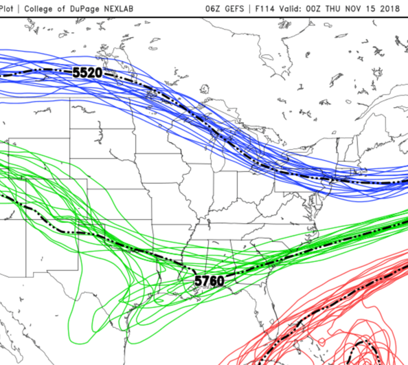
Majority of EPS members still show a piece of the energy holding back and not passing our latitude until next Thursday-Friday. Some show something like the operational, a few others try to make deep cut off west of us. Depending on individual track, I'd say about 1/3 - 1/2 of the EPS members give parts of our area a little (as in 1-3 if you are lucky) snow. The GFS says no on the secondary system, but some uncertainty evident on the GEFS spaghetti plots (image below). Even the NAM is trying to be a little bullish with the energy at the end of its run, closing off a 528 height line over N. TX. Sure it's the NAM and at the end of its run, but this sort of a solution has some support. Most of the solutions that show this coming out, pop a low too far east to bring any precip. into our area. Even my hobby horse from yesterday the ICON is waaayyyy south and east at 0z. But......how has the first wave trended over the past few days? Trying to understand the Typhoon Tip post cited by Carvers earlier and if I understand it correctly, this sort of shortwave might have a better chance at amplification since the geopotential heights associated with it are higher at a lower latitude, so there isn't as much gradient. I could be entirely misunderstanding that. Apologies if so. I think (if I had to give a percentage at this time: 75% chance) there will be a low form in the Gulf late next week and it will move NNE. Where this happens and how it moves remain to be seen, but if it happens at all, I think a NW trend will be part of it. Fall SE ridge seems to be stronger than models are seeing from distance. I also think unless this low cuts off and cranks up, any snow will be elevation based and nocturnal. I have to be in Hot Springs, NC all day next Friday, so I have vested interest.
- 185 replies
-
- 1
-
-
- first freeze
- temps
- (and 2 more)
-
Yeah, except for NW areas John mentions, starting to look like it's a done deal for the first wave. Even with some of the more SE tracks, it's still a very cold rain outside of those areas. I'm grabbing at straws (why not it's just November?), but I'm still kinda sorta interested in a possible secondary wave, from a bit of energy that cuts off over TX or N. Mexico. It's there on most models, but most string it out and kick it along or bury it. Ifs and buts....... I know, I know . The 12z ICON has it (I don't think the ICON has ever been right when it's on it's own), but the solution shown by the ICON today, was what the 12z UKMET and EURO had yesterday. The 12z GFS sorta kinda tries to do something similar, but everything is too positively tilted and kicked along by more northern stream energy. The UK and EURO still have it today, but it finally kicks out too little too late. A few of the EPS members have it (member 43 is a monster cut off). Three or maybe four GEFS members have it too. Not in any way trying to get anyone's hope up about something that a handful of ensemble members have, but I think something like this is still on the table. It seems like a delicate and subtle thing that may not be resolved until much closer and I'm just interested in seeing if it can happen.
- 185 replies
-
- 1
-
-
- first freeze
- temps
- (and 2 more)
-
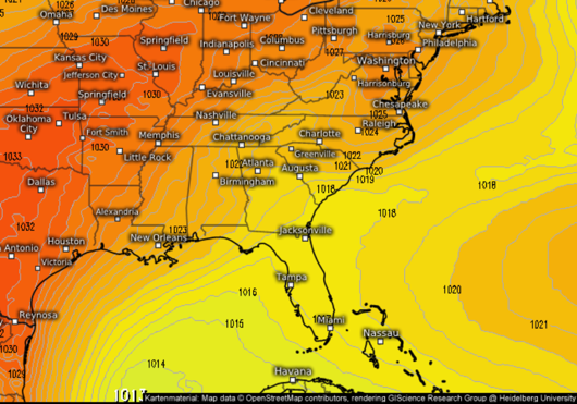
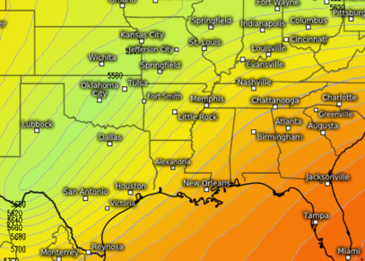
Any thoughts y'all on the odd ball solution the 12z Euro has thrown out? An initial low runs up the apps (what we're taking about above), but that isn't the bulk of the energy now. Some 500 mb energy digs into TX, holds back a bit, and cuts off. It then rolls through the south in an ideal track for parts of our area. Maybe 1/3 of EPS members show some form of this, some better some worse regarding the energy's track. This energy is at least there on the 12z CMC, if much more positively tilted. The 12z GFS has it too, but buries it in Northern Mexico and scoots it out, shredded across the gulf coast. FV3 shreds it out too. Maybe 3 GEFS members try something similar to the EURO/EPS with the energy. ICON is kinda trying at the end of its run. UKMET has it too, and looks quite a but like the EURO out to 6 days, but maybe 200 miles further west with the energy. It looks like it is popping a low waaayyyyy down in the Gulf with nowhere to go but NNE... Image is the UKMET at 12z next Wednesday (1 is MSLP and 2 is 500 geopotential heights). source: https://weather.us/model-charts/gbr/usa-east/sea-level-pressure/20181114-1200z.html source: https://weather.us/model-charts/gbr/usa-east/geopotential-height-500hpa/20181114-1200z.html
- 185 replies
-
- 3
-
-
- first freeze
- temps
- (and 2 more)
-
I was really happy with how the EURO had been looking until this 0z, since there was something there, but it was suppressed with 7+ days for changes and trends. This morning's 0z EURO inland runner up the Apps is no bueno for me, but is only one run 6-7 days out. Changes for better or worse are guaranteed. 6z GFS, FV3 soon-to-be new GFS, 0z CMC are a little further south and less amplified. I only have access to the UKMET out to 6 days, but at MSLP it looks like a compromise between the oz EURO and 6z GFS. Same at 500 mb geopotential heights. Looking though EPS members there seem to be 2 camps. One camp follows the Operational, one way or another: shallower or deeper, positive or more neutral tilted 500 trough cruising on through. I think there is probably more to be said about the different possibilities within this camp, camps within camps, but I'm just not good enough at reading stuff that subtle and for me anyway, it's still too far out for me to want to. The other camp is cutting off the main trough somewhere over the southwest or mid continent. EPS average for MSLP on tropical tidbits is more SE. The crux for the Euro seems to me to be the energy that drops into the US this weekend: when, approach, and how that part works out. GEFS members. Quite a few have the dreaded Great Lakes low and 3 out of 17 have an inland runner as far west as the TN valley. Overall though the members are still as SE or quicker with the whole progression than the operational. Overall thoughts: I'm glad there's some confusion on the models. I'm happy the Euro is at least seeing a consolidated storm in the Gulf. Also happy that a compromise between all these would be a good track for parts of the valley. Although, I think I sound a little down in my ramblings on this potential storm, I'm not. Can I say something "feels" interesting about the whole set up without that being a kiss o' doom and without it being too banterish? As I've said before this fall: We are talking about a real potential set up and cold in mid November. There have been Januaries and Februaries lately where what we have coming up is the best we could do all winter. Also, there doesn't seem to be a feel of a Miller B to this mess next week, whatever happens. Just a straight up Gulf low coming north. For my location anyway, I'd like a longer term winter pattern that features more Miller As than Bs and however this works out, if it is a taste of what's to come later, I'll be happy.
- 185 replies
-
- 6
-
-
- first freeze
- temps
- (and 2 more)
-
I'm actually a little interested in this period now. No joke. After the bigger storm late next week, both operational GFS and Euro show energy trying to dig in almost immediately afterwards early the week of the the 12th. This energy is riding down on the trough carved out by the two larger storms this week. Way to far out for any details or much hope, but the possibility of a storm spinning up after a couple of larger storms carve out a trough has my interest. It's November, might as well get chasing muscles warmed up. 0z Canadian has it too this AM.
-
Plateau foliage from Morgan County:
- 110 replies
-
- 4
-
-
-
- fall
- temperatures
- (and 5 more)
-
Not sure why this is so big. Wind atop Leconte
- 110 replies
-
- 1
-
-
- fall
- temperatures
- (and 5 more)
-
Maples are looking brilliant in and around Knox. Oaks, maybe not so much, but they never seem to be colorful. I grew up near sweet gum trees and miss their colors. Knoxville maples not quite there, so hopefully this rain will not annihilate what's looking like on of the prettiest leaf shows in a while for me anyway. Heard good reports from Cumberland County, but haven't been there myself. Driving from Knoxville to Harriman today, the leaves didn't seem as vibrant around I-40 as in my neighborhood near downtown Knox.
- 185 replies
-
- 2
-
-
- first freeze
- temps
- (and 2 more)
