
Holston_River_Rambler
-
Posts
5,107 -
Joined
-
Last visited
Content Type
Profiles
Blogs
Forums
American Weather
Media Demo
Store
Gallery
Everything posted by Holston_River_Rambler
-
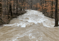
There is definitely some sort of ice falling now. Can''t tell if it's partially melted snow or sleet. I'm just east of downtown Knoxville.
-
Yeah, it looks like the surface low is just south of Macon. Th 850 low is still back in N. MS
-
Looks like the R/S line is creeping down the valley if the correlation coefficient is accurate. Wundermap is showing temps to 33-4 as far south as Severiville exit 407 on I-40. There have been so many micro changes here, that I'm not sure how accurate it is with this storm for the central valley, E TN valley
-

December 8-10 Storm Discussion
Holston_River_Rambler replied to Holston_River_Rambler's topic in Tennessee Valley
Correlation coefficient looks like the R/S line is trying to move west and south: https://imgur.com/a/AGAP1Ti -
December 8-10 Storm Discussion
Holston_River_Rambler replied to Holston_River_Rambler's topic in Tennessee Valley
There are some places in North Knox that are already 36, if Wunderground stations are accurate. Hopefully this heavier precip. will start to get the job done. According to NWS mesoscale analysis the 925 above 0 C line has just drastically shrunk. -
December 8-10 Storm Discussion
Holston_River_Rambler replied to Holston_River_Rambler's topic in Tennessee Valley
If I were going to go to Jacksboro, TN from out your way, I'd just keep on keeping and go to Ewing, VA (maybe 45 more min) and hike up to White Rocks overlook (3 miles). In fact, if I had the time tomorrow (if you have 4 wheel drive, you might be able to talk me into it) and thought my car could do the last .5 mile to the parking area, I'd be there. Over 3000 feet and likely no one but you. -
according to mesoscale analysis it is coming back south after being 30 miles north or so for the past 4 hours, unless I'm reading the site wrong 925 line still no bueno, but it is slightly shrinking
-
0 degree celsius 850 line has now settled back across Knox county
-
Looks like Radar is filling in towards NE TN. May the change over happen quick for y'all and may the snow pile up! Good luck to all up that way!
-
December 8-10 Storm Discussion
Holston_River_Rambler replied to Holston_River_Rambler's topic in Tennessee Valley
Really interesting to watch the radar and temps from Look Rock back to Knoxville Maybe 37 on top of Look Rock, layer of dense fog (that was in the process of raising) as I went down the mountain. About 1/3 of the way down the temp bottomed out at around 35 and then started back up. Low 40s or so in Knoxville and it looked like it hadn't even rained. Looking at NEXRAD radar it looks like the precip. is actually slowly backing away from Knoxville for now (don't take that to mean I think it's going away) Just interesting set up from foothills to valley today. -
December 8-10 Storm Discussion
Holston_River_Rambler replied to Holston_River_Rambler's topic in Tennessee Valley
Wanted to go check out the bright band over Maryville since I had a couple of almost too wet to be snowflakes. On the way saw Reb had already answered that question for me. Needed out of the house anyway. Ended up on look rock: https://imgur.com/a/GCiwrhZ One image is looking SW down the valley and the other to the smokies. Yeah I know there’s a camera but that’s no fun! Besides I couldn’t hear the pack of hounds in valley otherwise! 5-10 mph wind from the ENE and around 36-37 degrees. Still kind of pretty -
December 8-10 Storm Discussion
Holston_River_Rambler replied to Holston_River_Rambler's topic in Tennessee Valley
Don't think I've ever seen a warm nose run up the mts. This is at 925mb, 850 0 line is still way down near Chatt.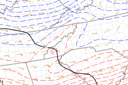
-
December 8-10 Storm Discussion
Holston_River_Rambler replied to Holston_River_Rambler's topic in Tennessee Valley
@John1122 yeah I'm just around 900 feet or so. I can see more up on the towers, but it is just super wet snow, with nothing but an ice crystal core left as far as I can tell -
December 8-10 Storm Discussion
Holston_River_Rambler replied to Holston_River_Rambler's topic in Tennessee Valley
Went outside to double check and it isn't sleet, it is just super melted wet snow plopping down. -
December 8-10 Storm Discussion
Holston_River_Rambler replied to Holston_River_Rambler's topic in Tennessee Valley
Actually, I have a little sleet here near downtown Knoxville. we'll see how long it lasts -
December 8-10 Storm Discussion
Holston_River_Rambler replied to Holston_River_Rambler's topic in Tennessee Valley
Looks like a rain/ snow line is trying to show up on MRX NEXRAD correlation coefficient. Also, a bright band down toward Maryville. -
December 8-10 Storm Discussion
Holston_River_Rambler replied to Holston_River_Rambler's topic in Tennessee Valley
That little band of precip brought 850 temps down quite a bit in the central valley. 850 0 degree Celsius line is into McMinn county now. Even the 925 0 degree Celsius line, which had been up near TRI, is now below Knox. -
December 8-10 Storm Discussion
Holston_River_Rambler replied to Holston_River_Rambler's topic in Tennessee Valley
Definitely rain at my house in Knoxville now, but if my ever reliable car thermometer can be believed, it's around 37. I can see snow falling about 1/3 of the way down the tallest radio tower on Sharp's ridge. Based on the height of that tower + Sharp's ridge, that puts the snow at this time in Knoxville at around 2200-2300 feet. I feel like if we just got a really heavy burst that might come down for a bit -
December 8-10 Storm Discussion
Holston_River_Rambler replied to Holston_River_Rambler's topic in Tennessee Valley
Yeah, seems like it's a bit early to me. Will be interesting to see how fat north in E TN it gets this AM. From about Jeff City on up temps and dewpoints look snowy. Saw that Hurricane Tracker, a Met in the SE forum for the NC mountains area, was saying that the High is verifying at 1039 mbs, higher than any guidance. Here in Knoxville near downtown nothing hitting the ground yet, but looks like snow may be up at the top if the towers on Sharp's Ridge. Hearing there is acc. snow in Crossville -
December 8-10 Storm Discussion
Holston_River_Rambler replied to Holston_River_Rambler's topic in Tennessee Valley
Hi-Res RGEM (even more hi-res than the regular RGEM) (on TT as the HRDPS) snow-water equivalent. Oddly enough posted by a NE poster, but in the SE forum. Maybe more good news for you NE TN and SWVA folk?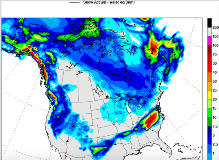
-
December 8-10 Storm Discussion
Holston_River_Rambler replied to Holston_River_Rambler's topic in Tennessee Valley
FWIW the 18z RGEM (colder) is currently doing better with surface temps than the NAM. @BlunderStorm for my part I'm in wait and see how it all develops mode, but hope you get as much snow as possible! Agree with Powell. If RAOB network soundings are causing shifts one way or the other, the southern parts of the vort are in Mexico and as far as I can tell there are no soundings there: http://weather.uwyo.edu/upperair/sounding.html I wonder if the mountains out that way are messing with vort. circulation and once it all comes out into the plains of TX it will reconsolidate any? Can't be much of an 850 low if the land is above 5000 feet. I have to say I'm happy with the solutions right now. Some heavy wet snow falling is a win for me. But can't help but wonder if a few more changes are in store on Hi-res mesoscale models once the whole shebang is in TX by 12 - 18z tomorrow. -
December 8-10 Storm Discussion
Holston_River_Rambler replied to Holston_River_Rambler's topic in Tennessee Valley
I'll take #1 @Blue Ridge extra points if the phrases: "poor run-to-run consistency" or "conferring with surrounding offices" or "hard to predict deformation axis" are included in the write up -
December 8-10 Storm Discussion
Holston_River_Rambler replied to Holston_River_Rambler's topic in Tennessee Valley
12z RGEM says “suppression? What suppression?” warm nose partly into SW VA based on snow maps. -
December 8-10 Storm Discussion
Holston_River_Rambler replied to Holston_River_Rambler's topic in Tennessee Valley
-
December 8-10 Storm Discussion
Holston_River_Rambler replied to Holston_River_Rambler's topic in Tennessee Valley
Kind of echoing what you just said, now I wonder, with the swifts south, do we get a NW trend at the last minute as the mid level lows get to, let's say the AL/GA line, or no? Besides the snow totals, I think the biggest trend long term for this system has been for the track to be more of a SW to NE, instead of an E to W. I'm hugging Feb 2015 right now, not the same system or set up, but hoping for similar last minute trends:

