Save the itchy algae!
-
Posts
212 -
Joined
-
Last visited
Content Type
Profiles
Blogs
Forums
American Weather
Media Demo
Store
Gallery
Everything posted by Save the itchy algae!
-

Winter 2024/2025 January Thread
Save the itchy algae! replied to AMZ8990's topic in Tennessee Valley
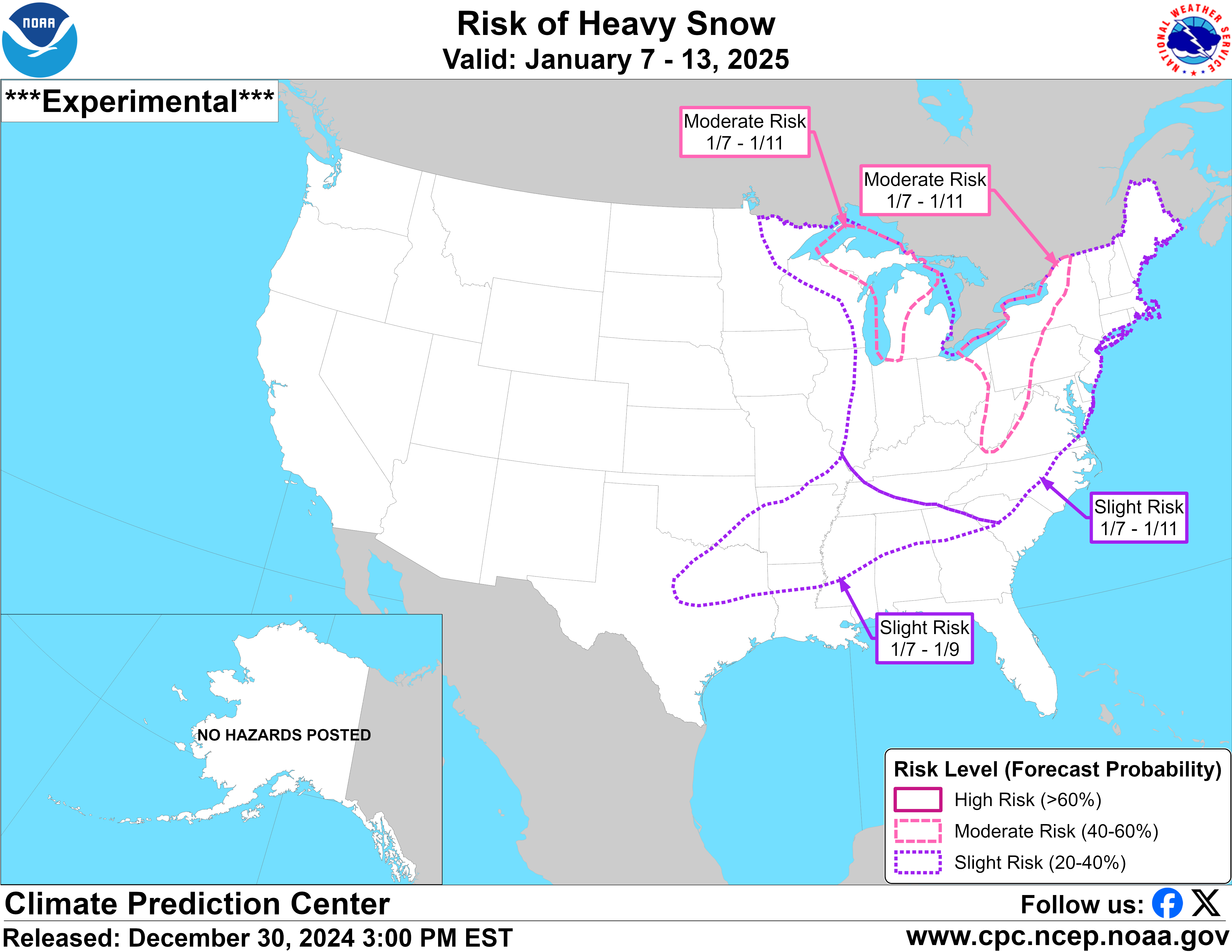
Sorry I don’t know how to edit my posts yet on Tapatalk (hate it) but I’m including the link to the discussion. It’s a fantastic read but it’s too long to copy https://www.cpc.ncep.noaa.gov/products/predictions/threats/threats.php . -
Winter 2024/2025 January Thread
Save the itchy algae! replied to AMZ8990's topic in Tennessee Valley
.
-
Winter 2024/2025 December Thread
Save the itchy algae! replied to AMZ8990's topic in Tennessee Valley
36 and rain leaving Farragut this am. Feels close to snow! . -
How did you only get 4.3” last season? We got 9” alone from that one storm and Farragut is usually one of the lowest snow total areas. .
-
Winter 2024/2025 December Thread
Save the itchy algae! replied to AMZ8990's topic in Tennessee Valley
Glad to be out of my slumber, bring on December! . -
February 2024 mid/ long range
Save the itchy algae! replied to Holston_River_Rambler's topic in Tennessee Valley
I’m surprised no one has commented on the 00z gfs. That’s quite a storm signal around that 18th~ish time frame, keeps popping up! .- 750 replies
-
- 2
-

-
- snow elk
- wooly worm
- (and 1 more)
-
It looks like this is pretty much it then the storm is done, anyone else seeing something different? .
-
It’s not just this post, but the AFD’s with all this coding or whatever is just unreadable. But it’s weird, when I quote it the text then becomes readable in my quote only.
- 372 replies
-
- 1
-
-
- cold
- arctic blast
- (and 1 more)
-
January 15th-17th 2024 Arctic Blast/Snow Event
Save the itchy algae! replied to John1122's topic in Tennessee Valley
How is that possible? . -
January 15th-17th 2024 Arctic Blast/Snow Event
Save the itchy algae! replied to John1122's topic in Tennessee Valley
Just finished driving home (Farragut) from Florida. I am super tired lol. Anyway, it was chilly all the way down. Around 60 at the beach, mid-upper 40’s near the fl/ga border, around 40 in Atlanta area, started seeing salt on roads around Lake Altoona area temp 38, temp was 34 around tunnel road in far n Georgia and chatty, ooltewah was where I saw light dust on some cars in car lots temp 34, didn’t see first flakes until around Cleveland and some brine, significant difference around sweetwater/philadelphia temp 30 and most everything covered except interstate, made it to house where there’s about an inch of snow-maybe a little less and everything covered, temp 27. Going to read the updated nws forecast then going to sleep . -
January 15th-17th 2024 Arctic Blast/Snow Event
Save the itchy algae! replied to John1122's topic in Tennessee Valley
This is bonus snow right now, not the actual event. . -
January Medium-Long Range Discussion
Save the itchy algae! replied to Holston_River_Rambler's topic in Tennessee Valley
My last name is Murphy. Nobody wants me starting it. I have laws named after my luck. . -
January Medium-Long Range Discussion
Save the itchy algae! replied to Holston_River_Rambler's topic in Tennessee Valley
So are we just gun shy on starting a thread? Western parts of the forum are just a few days out. . -
January Medium-Long Range Discussion
Save the itchy algae! replied to Holston_River_Rambler's topic in Tennessee Valley
Testing… ..I hate Tapatalk . -
Since I moved to the valley in 2015 March has been my second snowiest month on average.
-
Historic Christmas Cold & maybe snow?! Dec 23rd-30th
Save the itchy algae! replied to Wurbus's topic in Tennessee Valley
We’re over an inch here in Farragut. It sticks to everything, it’s an icy mess. -
I signed that waver when I created my account. Spill it Carvers!
- 582 replies
-
- 7
-

-
-

-
- snow
- freezing rain
- (and 4 more)
-
Fall 2022 Medium/Long Range Forecast Discussion
Save the itchy algae! replied to Carvers Gap's topic in Tennessee Valley
I know it won’t happen but there’s a major hurricane approaching Florida in the long range GFS. F* that mess. -
Fall 2022 Medium/Long Range Forecast Discussion
Save the itchy algae! replied to Carvers Gap's topic in Tennessee Valley
Yeah I’m just going to hold off with my thoughts for a while, things were looking good until I opened my mouth then next thing you know everything went poof. -
Fall 2022 Medium/Long Range Forecast Discussion
Save the itchy algae! replied to Carvers Gap's topic in Tennessee Valley
The gfs has been consistently showing a tropical signature the end of Halloween week. Given it’s placement and climatology I wouldn’t be surprised to see some unusual weather in the nov 7-10th range. -
Fall 2022 Medium/Long Range Forecast Discussion
Save the itchy algae! replied to Carvers Gap's topic in Tennessee Valley
Just got back from prepping the other home for the storm, the Floridians don’t care in my area…was the only one sandbagging. With the track shifting south east they may take it more seriously now. The locals are saying Ian is a Hurricane Charley clone. -
Fall 2022 Medium/Long Range Forecast Discussion
Save the itchy algae! replied to Carvers Gap's topic in Tennessee Valley
Curious what Hurricane Ian does to the area. Historically Tropical systems have a way of setting in fall some years but summer has already largely eased off any way. Could be some blustery days ahead for higher elevations. -
Fall 2022 Medium/Long Range Forecast Discussion
Save the itchy algae! replied to Carvers Gap's topic in Tennessee Valley
Oops -
I’m supposed to be driving to the beach on Friday but there’s no way I’m missing this storm. Wife will hate me but Florida can wait.