midatlanticweather
-
Posts
4,926 -
Joined
-
Last visited
Content Type
Profiles
Blogs
Forums
American Weather
Media Demo
Store
Gallery
Everything posted by midatlanticweather
-
-
0.23 here in Purcellville overnight. That was a surprise because I did not even realize it was that much!
-

2022 Mid-Atlantic Severe Wx Thread (General Discussion Etc)
midatlanticweather replied to Kmlwx's topic in Mid Atlantic
Looks like a lot of crapvection is robbing potential. Some breaks northern Loudoun and north but the stuff to the south is eroding the instability.
-
73.. and so nice out there! Pollen accumulating though, so sneezing is quite common!
-
Snowballs falling in Purcellville!!
-
Paved driveway is caving on the edges and anywhere that is colder due to shade. 32.7 degrees with heavy snow in Purcellville.
-
Incredible! Down to 33 degrees with heavy snow! All grass, mulch, and now cars getting white. Deck is covered! 33/32
-
We have gone to heavy snow! Grass is getting covered with these rates. It is crazy!
-
We have a Mulch Whitening event now! Snow is really coming down, visibilities coming down! Still 34 degrees but snow is the predominant type, though I can tell there is rain in it.
-
70% snow at this point! Down to 34 degrees! This is crazy!
-
Rain, sleet, and even occasional wet snowflakes.. Slowly seeing more Snowflakes. Crazy! 39/30
-
2022 Mid-Atlantic Severe Wx Thread (General Discussion Etc)
midatlanticweather replied to Kmlwx's topic in Mid Atlantic
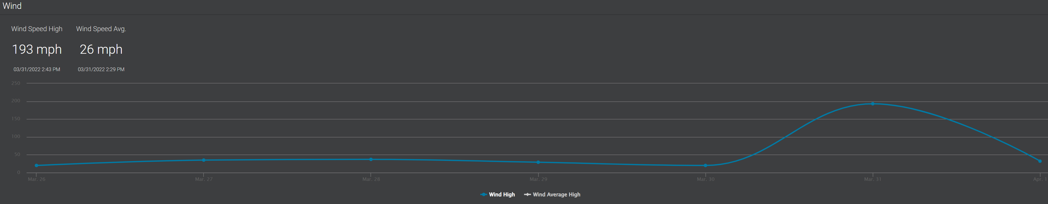
My Weather Station playing an April Fools on March 31. We lost power for a little over an hour yesterday. When the weather station relayed the wind speed after the power was restored it showed a wind of 193 MPH. I can confirm, that was greatly exaggerated! LOL!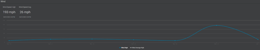
-
2022 Mid-Atlantic Severe Wx Thread (General Discussion Etc)
midatlanticweather replied to Kmlwx's topic in Mid Atlantic
They seem to be waiting until the last minute! LOL! -
2022 Mid-Atlantic Severe Wx Thread (General Discussion Etc)
midatlanticweather replied to Kmlwx's topic in Mid Atlantic
That notch is looking interesting for sure! Will be interesting to watch -
2022 Mid-Atlantic Severe Wx Thread (General Discussion Etc)
midatlanticweather replied to Kmlwx's topic in Mid Atlantic
That highland and Pendleton cell looks interesting! We will get some better views once it makes it over the ridge -
2022 Mid-Atlantic Severe Wx Thread (General Discussion Etc)
midatlanticweather replied to Kmlwx's topic in Mid Atlantic
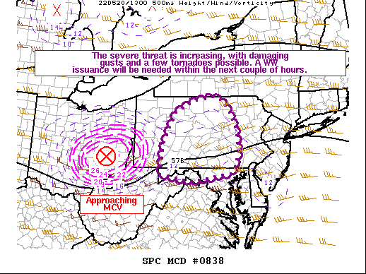
So is that Crapvection out here in Loudoun, or an area that may end up doing something! I swear I saw this area on the HRRR earlier! Pretty wild to see stuff form where models thought. -
2022 Mid-Atlantic Severe Wx Thread (General Discussion Etc)
midatlanticweather replied to Kmlwx's topic in Mid Atlantic
-
2022 Mid-Atlantic Severe Wx Thread (General Discussion Etc)
midatlanticweather replied to Kmlwx's topic in Mid Atlantic
Looking pretty windy tomorrow. Regardless of the intensity of the storms, I suspect gusty winds that could cause some damage and wind advisories. Also, latest models are showing areas have a chance to see 1 to 1.25 inches of rain! Really need that rain! -
Bit Late --- At 1024 AM EDT, a snow squall was located near Clover Hill, or near Frederick, moving east at 45 mph. Winds in excess of 30 mph are possible with this squall. Locations impacted include... Frederick, Westminster, Thurmont, Harry Grove Stadium, Eldersburg, Ballenger Creek, Mount Airy, Walkersville, Braddock Heights, New Market, Clover Hill, Discovery-Spring Garden, Linganore-Bartonsville, New Windsor, Woodsboro, Union Bridge, Libertytown, Monrovia, Winfield and New Midway. Visibilities will drop quickly to less than a quarter of a mile in this squall. Use extra caution if you must travel into or through this dangerous snow squall. Rapid changes in visibility and potentially slick roads are likely to lead to accidents. Consider delaying travel until the squall passes your location.
-
Nice Snow Squall Warning up that way!
-
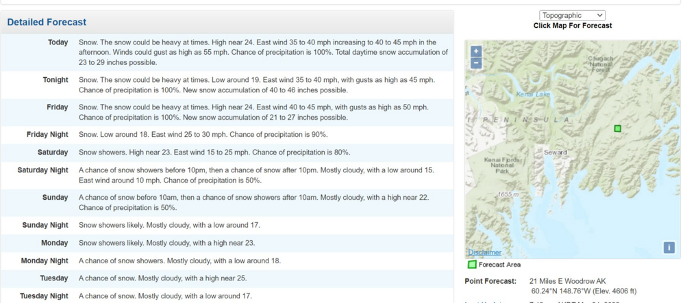
Trip to Alaska anyone? https://forecast.weather.gov/MapClick.php?lon=-148.72784603387115&lat=60.27862855543319#.Yjyp6OdKhjE I like the "Could be Heavy at times" - You think? 40 inches in 12 hours!
-
And this is the star of Twitter today, if you have not seen it!
-
Oh ya! Ryan Hall is awesome! I was watching him late into the evening as well. Two of the chasers (including Reed) pretty much had the tornado hit them.
-
The pump is primed for Tornadoes! Good Grief!
-
March Medium/Long Range Discussion
midatlanticweather replied to WinterWxLuvr's topic in Mid Atlantic
Is there a Winter 2022-2023 Thread yet? This would stink if we 3-peat!