midatlanticweather
-
Posts
4,915 -
Joined
-
Last visited
Content Type
Profiles
Blogs
Forums
American Weather
Media Demo
Store
Gallery
Everything posted by midatlanticweather
-
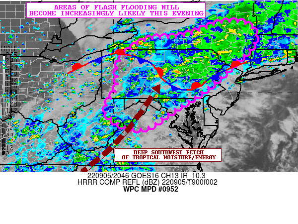
Mesoscale Precipitation Discussion 0952 NWS Weather Prediction Center College Park MD 450 PM EDT Mon Sep 05 2022 Areas affected...Portions of the Central Appalachians...Northern Mid-Atlantic...Central/Southern NY Concerning...Heavy rainfall...Flash flooding likely Valid 052050Z - 060250Z SUMMARY...Persistent areas of heavy rain with locally focused areas of showers and thunderstorms producing enhanced rainfall rates are expected to drive an increasing threat of flash flooding heading through the evening hours. DISCUSSION...The latest GOES-16 IR/WV suite shows a deep layer southwest fetch of moisture and energy aloft traversing a large area of the eastern U.S. with an emphasis on the Appalachians, northern Mid-Atlantic and southern New England this afternoon. Already areas of heavy rain with locally embedded pockets of stronger convection are impacting areas from central WV northeast through central to northeast PA, and across areas of central and southern NY. The airmass out across the eastern slopes of the Appalachians and the Piedmont areas of the central/northern Mid-Atlantic has been gradually destabilizing over the last several hours with the persistence of at least filtered solar insolation. MLCAPE values have increased locally to 500 to 1000 j/kg. Meanwhile, PWs across the region are high with values of 1.8 to 2.0 inches which are locally over 2 standard deviations above normal for this time of the year. Over the next several hours, this moisture and energy transport up from the south and southwest will be interacting with some of the more orographically favored terrain along and adjacent to the Blue Ridge from eastern WV through south-central and southeast PA for concerns of locally focused and slow-moving showers and thunderstorms. Radar imagery over the last couple of hours has been showing the development and expansion of convective activity as confluent low-level flow and the improving thermodynamic environment focuses across these areas. Meanwhile, areas farther north across north-central to northeast PA and adjacent areas south-central and southeast NY will also be a focus area for locally very heavy rainfall, and especially with a front stalled out across this region. Stronger frontogenetical forcing and isentropic ascent more broadly over the region coupled with pockets of elevated instability are expected to maintain a broad shield of moderate to locally heavy rain, but with localized swaths of slow-moving convection capable of enhanced rainfall rates. Warm rain processes will be in place this evening given the deeper layer transport of tropical moisture into the region and with much of the forcing noted in the lower/mid-levels of the column. This will yield some efficiently high rainfall rates that will occasionally reach 2 to 3+ inches/hour. Additional rainfall amounts at least locally going through 03Z this evening may reach 3 to 5 inches, with some of the heavier signals for this showing up over areas of south-central NY. Observational trends suggest areas of south-central to northeast PA will need to be closely monitored for similar rainfall amounts. Given the enhanced to locally extreme rainfall rate potential, and the storm totals through mid-evening, the threat for flash flooding will be increasing over the next several hours. Orrison ATTN...WFO...ALY...BGM...BUF...CTP...LWX...OKX...PBZ...PHI... RLX... ATTN...RFC...MARFC...NERFC...OHRFC...NWC...
-
This was the greenest summer I remember. The grass mowing was relentless! My mower struggled in some of it due to the added weeds that seemed to thrive as well.
-
Still was able to get into the low 90s with heat index values up to 103 at one point! COME ON COOL AIR!
-

2022 Mid-Atlantic Severe Wx Thread (General Discussion Etc)
midatlanticweather replied to Kmlwx's topic in Mid Atlantic
Lackluster Meso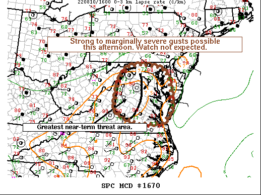
-
93/74 ain't no fun! Bring on some storms to knock this down please!
-
That outflow boundary was awesome! I am down to 76.. like shivering almost compared to earlier! It is insanely humid though!
-
Super hot! Hit 96 at one time but holding 94 now and a DP of 75 making it feel like a toasty 106!!!!!!
-
Good downpours out here in Purcellville! Seeing over 0.60 inches so far! My grass will never stop growing. It is nice that we all have green.. just makes it a weekly must do!
-
2022 Mid-Atlantic Severe Wx Thread (General Discussion Etc)
midatlanticweather replied to Kmlwx's topic in Mid Atlantic
That storm blew up quick. Good winds, few good bolts, power flashes.. but now to the east! Was fun little storm! Down to 72 degrees now. -
2022 Mid-Atlantic Severe Wx Thread (General Discussion Etc)
midatlanticweather replied to Kmlwx's topic in Mid Atlantic
Could see some gusty storms later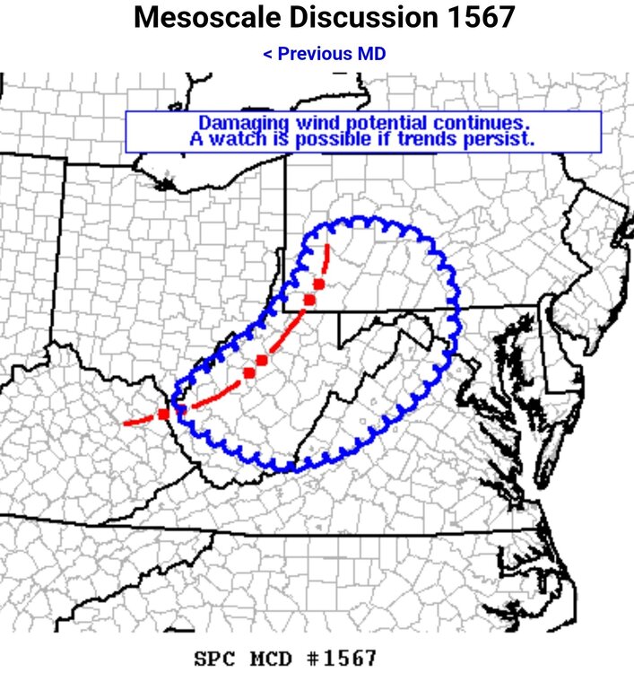
-
These are not the 100s I was looking for!
-
2022 Mid-Atlantic Severe Wx Thread (General Discussion Etc)
midatlanticweather replied to Kmlwx's topic in Mid Atlantic
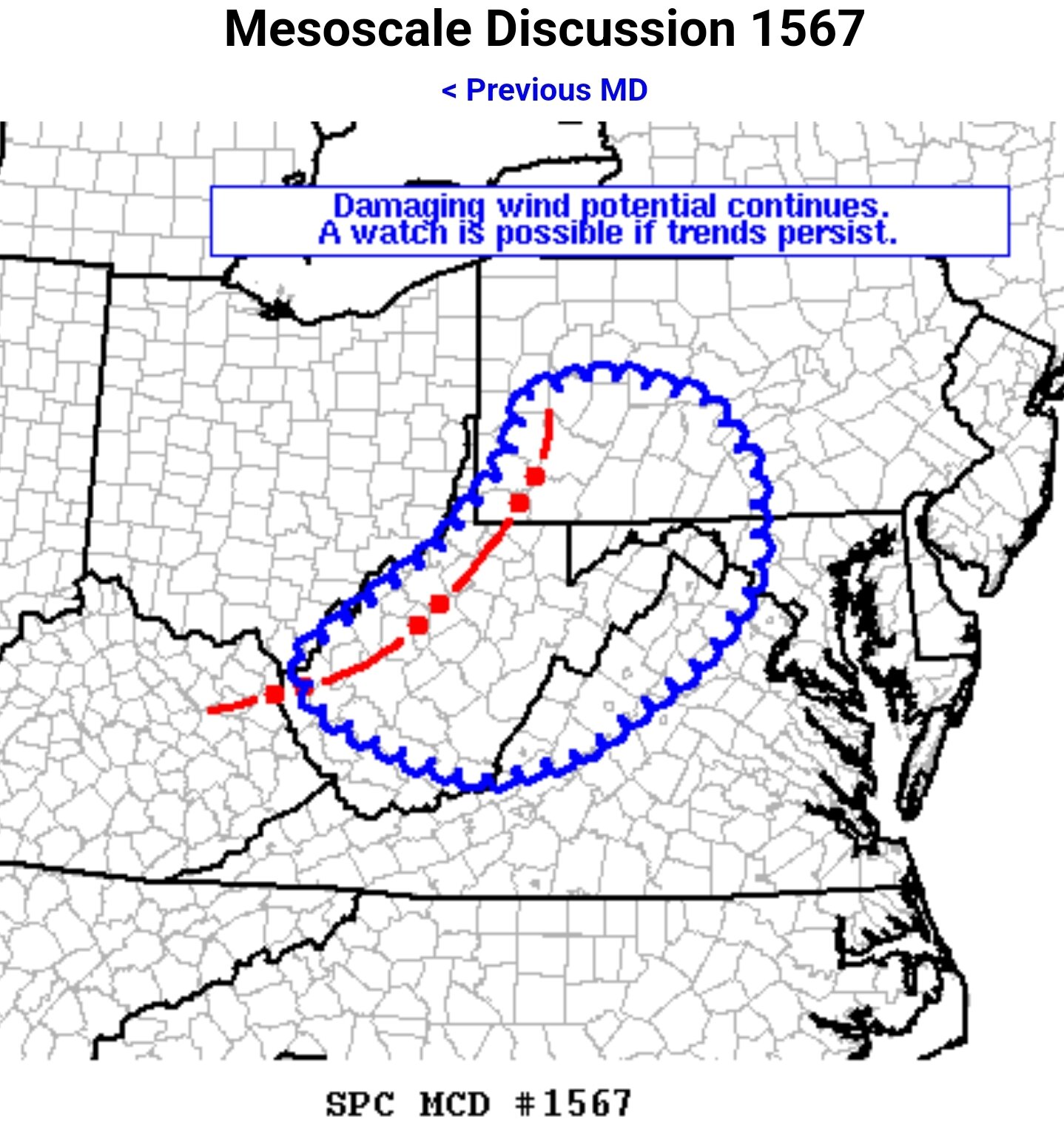
Meso update https://www.spc.noaa.gov/products/md/md1511.html Focus is shifting North and east (as it should) DISCUSSION...Widely scattered thunderstorms continue along the I-95 corridor this afternoon from near Washington D.C. to the NYC vicinity. Some of these storms have produced near-severe measured wind gusts as well as sporadic wind damage. This activity will continue to pose a threat for damaging gusts the next few hours. Occasional weak rotation has been noted at times as well, especially with storms further north across NJ/NY where low-level shear remains stronger compared to further south. -
2022 Mid-Atlantic Severe Wx Thread (General Discussion Etc)
midatlanticweather replied to Kmlwx's topic in Mid Atlantic
-
2022 Mid-Atlantic Severe Wx Thread (General Discussion Etc)
midatlanticweather replied to Kmlwx's topic in Mid Atlantic
That cell down in Bedford looks interesting. Not in the area but looks like it had good rotation at a point. -
2022 Mid-Atlantic Severe Wx Thread (General Discussion Etc)
midatlanticweather replied to Kmlwx's topic in Mid Atlantic
Wow! Just had a "bolt out of the blue" here near Purcellville. Was super crazy bright with amazing thunder. Wow! -
2022 Mid-Atlantic Severe Wx Thread (General Discussion Etc)
midatlanticweather replied to Kmlwx's topic in Mid Atlantic
I was fringed by the heavier winds and got some marble sized hail in Purcellville. Nice strong storm, nice mammatus.. but not too bad. -
2022 Atlantic Hurricane Season Tracking Thread
midatlanticweather replied to WxWatcher007's topic in Mid Atlantic
-
Feels soupy for sure! I almost feel I could create a localized cell if I open my air conditioned home and cause condensation from the temp differential! That being said, I see the puffs now on the satellite and the isolated cells so we must have hit critical temp points to start some action. That looks especially true for any areas that were really clear for a bit and likely hottest. 86 with a DP of 72 here in Purcellville. The air is thick!
-
2022 Mid-Atlantic Severe Wx Thread (General Discussion Etc)
midatlanticweather replied to Kmlwx's topic in Mid Atlantic
BULLETIN - EAS ACTIVATION REQUESTED Tornado Warning National Weather Service Mount Holly NJ 620 PM EDT Tue Jul 5 2022 The National Weather Service in Mount Holly NJ has issued a * Tornado Warning for... West central Talbot County in eastern Maryland... Southwestern Queen Anne's County in northeastern Maryland... * Until 700 PM EDT. * At 619 PM EDT, a severe thunderstorm capable of producing a tornado was located over Kent Point, or near Shady Side, moving east at 20 mph. HAZARD...Tornado. SOURCE...Radar indicated rotation. IMPACT...Flying debris will be dangerous to those caught without shelter. Mobile homes will be damaged or destroyed. Damage to roofs, windows, and vehicles will occur. Tree damage is likely. * Locations impacted include... Talbot, Romancoke and Tilghman Island. N -
2022 Mid-Atlantic Severe Wx Thread (General Discussion Etc)
midatlanticweather replied to Kmlwx's topic in Mid Atlantic
TORNADO WARNING Tornado: OBSERVEDHail: <.75IN ...A TORNADO WARNING REMAINS IN EFFECT UNTIL 430 PM EDT FOR SOUTHEASTERN MIDDLESEX AND SOUTHEASTERN LANCASTER COUNTIES... At 415 PM EDT, a confirmed tornado was located near White Stone, moving southeast at 25 mph. HAZARD...Damaging tornado. SOURCE...Weather spotters confirmed tornado. IMPACT...Flying debris will be dangerous to those caught without shelter. Mobile homes will be damaged or destroyed. Damage to roofs, windows, and vehicles will occur. Tree damage is likely. This tornado will be near... White Stone around 420 PM EDT. Other locations impacted by this tornadic thunderstorm include Hardyville, Weems, Christ Church, Wake, Greys Point and Wilton. Close -
2022 Mid-Atlantic Severe Wx Thread (General Discussion Etc)
midatlanticweather replied to Kmlwx's topic in Mid Atlantic
Tor down SE VA BULLETIN - EAS ACTIVATION REQUESTED Tornado Warning National Weather Service Wakefield VA 335 PM EDT Tue Jul 5 2022 The National Weather Service in Wakefield has issued a * Tornado Warning for... Northwestern Middlesex County in eastern Virginia... South central Richmond County in east central Virginia... Southeastern Essex County in east central Virginia... Western Lancaster County in eastern Virginia... * Until 400 PM EDT. * At 334 PM EDT, a severe thunderstorm capable of producing a tornado was located near Morattico, or near Robley, moving east southeast at 25 mph. HAZARD...Tornado. SOURCE...Radar indicated rotation. IMPACT...Flying debris will be dangerous to those caught without shelter. Mobile homes will be damaged or destroyed. Damage to roofs, windows, and vehicles will occur. Tree damage is likely. -
2022 Mid-Atlantic Severe Wx Thread (General Discussion Etc)
midatlanticweather replied to Kmlwx's topic in Mid Atlantic
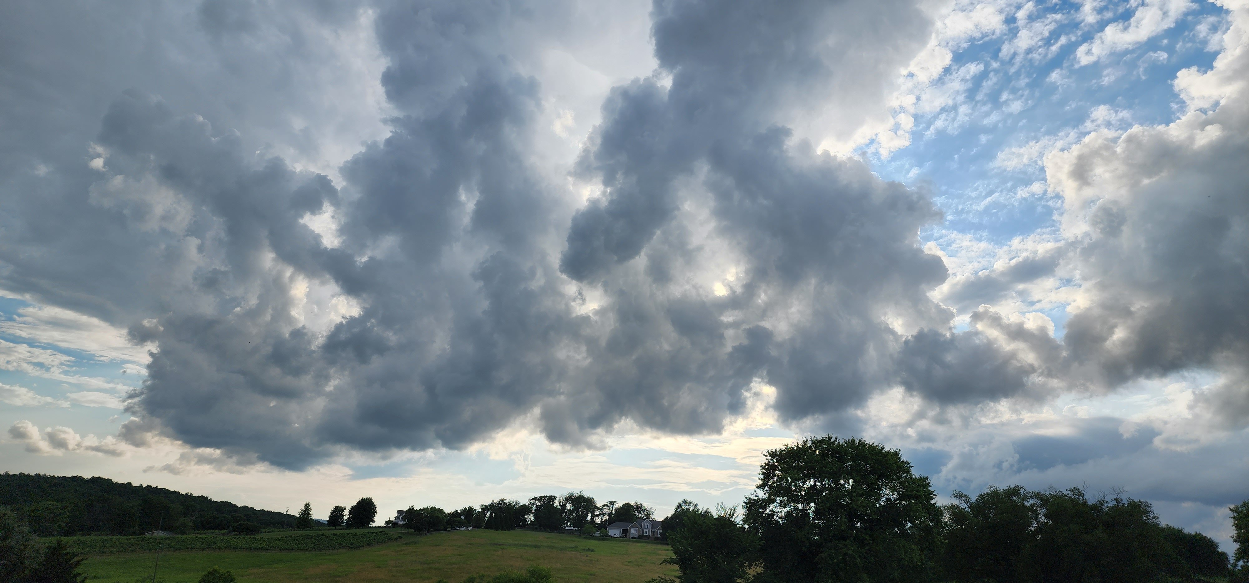
Here is that boundary in Loudoun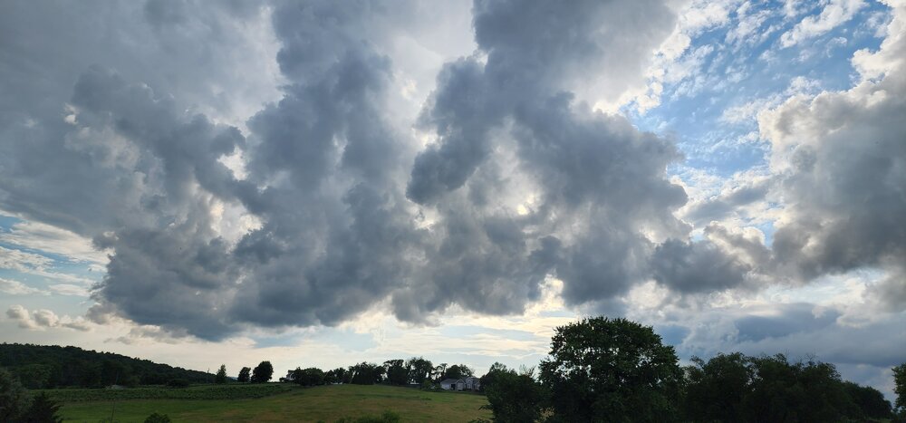
-
2022 Mid-Atlantic Severe Wx Thread (General Discussion Etc)
midatlanticweather replied to Kmlwx's topic in Mid Atlantic
-
2022 Mid-Atlantic Severe Wx Thread (General Discussion Etc)
midatlanticweather replied to Kmlwx's topic in Mid Atlantic
https://www.spc.noaa.gov/products/md/md1314.html -