

midatlanticweather
-
Posts
4,922 -
Joined
-
Last visited
Content Type
Profiles
Blogs
Forums
American Weather
Media Demo
Store
Gallery
Everything posted by midatlanticweather
-
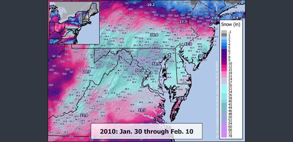
12 Years ago we had just been through one of the most epic times ever! Nothing has matched it!
- 613 replies
-
- 10
-

-

-

-

February Medium/Long Range Discussion
midatlanticweather replied to snowmagnet's topic in Mid Atlantic
I feel like I have seen this before.... -
February Medium/Long Range Discussion
midatlanticweather replied to snowmagnet's topic in Mid Atlantic
I suspect we phase too late.. but it does have that feel of the storm earlier this year that was phased with the northern stream as it hit our latitude. I think a miss to the south at this point is the biggest concern.. but, in the Mid Atlantic, we always have a million concerns.. so many ways to fail.. need the luck to win! -
February Medium/Long Range Discussion
midatlanticweather replied to snowmagnet's topic in Mid Atlantic
That was close! -
February Medium/Long Range Discussion
midatlanticweather replied to snowmagnet's topic in Mid Atlantic
Based on the lack of posting.. obviously the 18z GFS was nothing good for snow lovers. It was horrible.. but also it looked really messy and chaotic. -
February Medium/Long Range Discussion
midatlanticweather replied to snowmagnet's topic in Mid Atlantic
Well, next to Deep Thunder.... LOL -
February Medium/Long Range Discussion
midatlanticweather replied to snowmagnet's topic in Mid Atlantic
Just worried it will be warm and rainy! Time is running out! -
February Medium/Long Range Discussion
midatlanticweather replied to snowmagnet's topic in Mid Atlantic
Euro is a no-go late phase and huge to the right! Even upstream looks like it is a bad setup for anything to truly pop. -
February Medium/Long Range Discussion
midatlanticweather replied to snowmagnet's topic in Mid Atlantic
Just reiterating what we already know: -
February Medium/Long Range Discussion
midatlanticweather replied to snowmagnet's topic in Mid Atlantic
UK Met at 144 -
February Medium/Long Range Discussion
midatlanticweather replied to snowmagnet's topic in Mid Atlantic
Only 9.7 inches total here in Purcellville. That is a meager amount! We can usually nickel and dime our way to 15 inches or so by now. Pretty bad year. -
February Medium/Long Range Discussion
midatlanticweather replied to snowmagnet's topic in Mid Atlantic
Canadian as well. -
February Medium/Long Range Discussion
midatlanticweather replied to snowmagnet's topic in Mid Atlantic
Looks like it starts wrapping up, then kind of loses it and goes back positive after a brief negative. I mean.. something is there across models now! Something to watch again! -
39/37
-
Between 5:22 and 5:27AM the front came through my back yard. Temps dropped from 58 to 43 degrees by 6am. Now sitting at 39.
-
Last minute north pull - Thank goodness we were tracking ice and not snow. Seems like minimal impacts for many.
-
When do we start trusting the high resolution models? Tonight? Tomorrow? Mainly on cold air, not precip amounts.
-
Late January and February Medium/Long Range Discussion
midatlanticweather replied to WinterWxLuvr's topic in Mid Atlantic

- 4,130 replies
-
- 10
-

-
-
- prime climo
- cold canada
- (and 1 more)
-
Late January and February Medium/Long Range Discussion
midatlanticweather replied to WinterWxLuvr's topic in Mid Atlantic
The Low for the follow up was souther. The upper level support was definitely different. Look like we get Fringed! -
Late January and February Medium/Long Range Discussion
midatlanticweather replied to WinterWxLuvr's topic in Mid Atlantic
It is February! Think we need a new thread for the month- 4,130 replies
-
- 1
-
-
- prime climo
- cold canada
- (and 1 more)
-
Late January and February Medium/Long Range Discussion
midatlanticweather replied to WinterWxLuvr's topic in Mid Atlantic

- 4,130 replies
-
- 13
-
-
-
- prime climo
- cold canada
- (and 1 more)
-
Late January and February Medium/Long Range Discussion
midatlanticweather replied to WinterWxLuvr's topic in Mid Atlantic
Looks like a sleet bomb -
Late January and February Medium/Long Range Discussion
midatlanticweather replied to WinterWxLuvr's topic in Mid Atlantic
Came over here looking for hope! LOL

