midatlanticweather
-
Posts
4,926 -
Joined
-
Last visited
Content Type
Profiles
Blogs
Forums
American Weather
Media Demo
Store
Gallery
Everything posted by midatlanticweather
-

3/12 Event: Winters Last Hurrah at Least East of Mountains
midatlanticweather replied to Weather Will's topic in Mid Atlantic
Down to 28.5 degrees. Snow is taking a breather and light for now. More seems to be on the way. I wanted straight up heavy snow for 4 hours though!! Lol.. -
3/12 Event: Winters Last Hurrah at Least East of Mountains
midatlanticweather replied to Weather Will's topic in Mid Atlantic
Snow is falling, blowing, low visibility.. It is awesome outside!! Secondary streets are caving. Temp is down to 29.6 degrees. What a beautiful day!! -
3/12 Event: Winters Last Hurrah at Least East of Mountains
midatlanticweather replied to Weather Will's topic in Mid Atlantic
How are people feeling about Thundersnow possibilities? -
3/12 Event: Winters Last Hurrah at Least East of Mountains
midatlanticweather replied to Weather Will's topic in Mid Atlantic
NAM cut back though! I mean, I think it is probably more realistic than the nice 6Z run, but I was hoping for a hold or increase (aren't we always!) -
3/12 Event: Winters Last Hurrah at Least East of Mountains
midatlanticweather replied to Weather Will's topic in Mid Atlantic
Zone forecast for Purcellville just went to 3 to 5 inches of snow. Seems WAY bullish by NWS. I am thinking 1 to 3 at best! That seems to line up with the LWX Winter maps. Not sure why the Local went so high. Saturday: Rain and snow, becoming all snow after 10am. The snow could be heavy at times. High near 36. Breezy, with a northwest wind 16 to 25 mph, with gusts as high as 49 mph. Chance of precipitation is 100%. New snow accumulation of 3 to 5 inches possible. -
March Medium/Long Range Discussion
midatlanticweather replied to WinterWxLuvr's topic in Mid Atlantic
I am definitely no meteorologist, but I wonder if there also a correlation to the heat of the ocean on the east coast. To me, when they are as anomalously warm as they are now it is a factor that can influence the impact of the marginal temps. Maybe I am grasping at straws.. but I just wonder.. yes, that can help juice up storms at times so it can be helpful, but I also think it messes things up. The Ocean is off the chart above normal!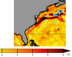
-
March Medium/Long Range Discussion
midatlanticweather replied to WinterWxLuvr's topic in Mid Atlantic
As we know, back end snow is iffy and usually a fail! Additionally, flash freezes are rare! You get a burst of snow, followed by cold, and the sun has set I could see it possibly happening. I have seen that before, but I know flash freezes are rare for us, challenging to predict, and far less likely this time of year. -
Wednesday March 9th wet snow(snow TV?) threat
midatlanticweather replied to George BM's topic in Mid Atlantic
Ok - Sorry for the spam of maps.. we all know temps will be marginal, the ground will be warm, the accumulations will be mulch and shaded grassy spots as well as tops of cars and far less than what those maps show until you get to higher elevations.... but snow tv is a coming from all models now for folks N&W of the beltway according to the latest models.. We will see if they hold. -
Wednesday March 9th wet snow(snow TV?) threat
midatlanticweather replied to George BM's topic in Mid Atlantic
Nam 3K.thumb.png.afd8148e9b35a9c1b63fa67cd0a70784.png)
-
Wednesday March 9th wet snow(snow TV?) threat
midatlanticweather replied to George BM's topic in Mid Atlantic
And GFS - I know the clown maps!.thumb.png.8dbba56cf837fea33830cd590c600778.png)
-
Wednesday March 9th wet snow(snow TV?) threat
midatlanticweather replied to George BM's topic in Mid Atlantic
NAM'd I see! Of course taken with a grain of salt, sun angle, temp challenges, etc.... It is the NAM after all!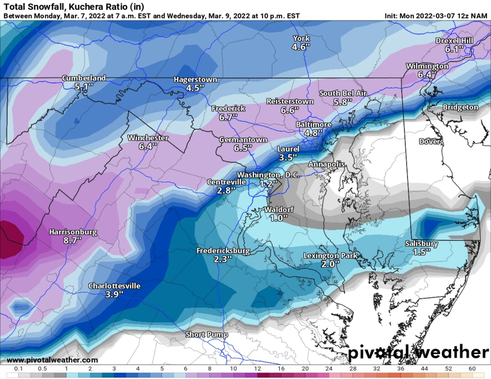
-
February Medium/Long Range Discussion
midatlanticweather replied to snowmagnet's topic in Mid Atlantic
Winter weather looks done! Cold a few days.. Probably.. Any snow seems like a fantasy
-
31.3/31...some ice on cars and tree branches, but nothing on roads and the deck is just wet except where there was shade I see some ice trying
-
37. Hit the opposite of that earlier wih 73!
-
This is a crazy forecast!
-
Had a high of 72.7 but have "cooled" to 68 with gusty NW winds.
-
February Medium/Long Range Discussion
midatlanticweather replied to snowmagnet's topic in Mid Atlantic

-
February Medium/Long Range Discussion
midatlanticweather replied to snowmagnet's topic in Mid Atlantic
The window for a big event seems to have been shut down. Climo says MAYBE we get a little fun, but this winter is almost ready for a fork, a serenade, a Schwarzenegger Spanish goodbye..... Close the blinds.... (hopefully 12z just smacks me silly and brings it.. but I doubt it!) Severe season is close! -
February Medium/Long Range Discussion
midatlanticweather replied to snowmagnet's topic in Mid Atlantic
Improved, but a lot of white rain if temps, timing, and rates do not improve! But at least it is now in the vicinity! This one has warmth screaming a disappointment. -
February Medium/Long Range Discussion
midatlanticweather replied to snowmagnet's topic in Mid Atlantic
Anyone have thoughts on that quick moving squally snow line on Saturday? Just interesting! Shows up on the 18z HRRR and NAM 3k - -
February Medium/Long Range Discussion
midatlanticweather replied to snowmagnet's topic in Mid Atlantic
@StormchaserChuck! Well, lookie here! -
Went to all snow. Coming down pretty good too!
-
Snow rain mixed now 38/28
-
Band of Precip is east of me in Purcellville.. but it looks like rain from what I can see in Eastern Loudoun. 39.8/27
-
40/26 dry


.png.5cac11f6a62754ebfd56f173b9950aad.png)
.png.821ca7b81fb335a5002985f4b1a92663.png)