Albedoman
-
Posts
1,380 -
Joined
-
Last visited
Content Type
Profiles
Blogs
Forums
American Weather
Media Demo
Store
Gallery
Everything posted by Albedoman
-
Too early to say. If the La Nina takes its time breaking down, sometime in May. Still can get late April rains to kill the potential drought though but Feb and March are not looking good right now for any huge precip event. All it takes though is one good snowfall storm event of 12-18 inches in Feb to provide us with a good recharge. Lets hope this happens by Valentines Day.
-
Wow, it appears I hit this moving target in the bullseye. No biting for me. It appears another use of the leaf blower for this snow event. Gotta charge up the battery. LMAO +++++++++++++++++++++++++++++++++++++++++++++++++++++++++++++++++++++++++++++++++++++++++++++++++++++++++++++++++ I do not believe we get jack crap. OTS or hits Long island Boston area. The cards are not in play at this time. That storm has to be at least 150 miles more sw and wrapped around and amped like hell. The best storms are down at the BM at the Chesapeake Bay. Furthermore, the mid range models are so far off in this PA jet progressive pattern that it is scary. When the Nam shows it at the 60 hour mark, I will bite at it. Until then time to just watch the mood flakes fall tonight. Honestly this weather pattern is equal to the volatility of todays stock market activity - and thats bad. I might as well be reading the futures in the market for our... Monday at 05:09 PM 1,934 replies 2
-
cmon hold on to your poker face a little longer. This is an OTS storm. For the LV, 1-3 inches thats it
-
well posters, please send this potential storm to the graveyard of fails for this winter season. Never even got out of the starting gate. The dry progressive air pattern keeps on beating these storms down as they form off the coast. Whats next? Whats so heartbreaking for snow lovers is that the GFS long range indicates a fantasy storm five days out only to never reappear again. Run after run indicates a 6+ inch storm only to disappear and get pushed back for another week. You cannot even establish any pattern to this progressive split flow. Again, the only concern I have is that the drought potential is not going away in this current weather pattern and if we do not get some significant precip whether rain or snow, into the ground water tables, they will fall pretty quick in early April as temps rise. Our current weather pattern scenario reminds me a lot of the winter of 93 before the March superstorm hit. It will take a major hitter to break this stubborn pattern for sure.
-
yes that was a nice storm event. I like your summation so far on facebook but I am concerned that the storm bombs out past the BM leaving us with scraps this time. The last storm barreled through in this progressive pattern which hints this storm may only slow down once gets near LI. I think tonight's OZ Nam run will tells us if the storm will have enough energy before it hits the benchmark to throw bands off the ocean and toward eastern PA. Nothing better than having orographic lifting from east to west which is good for us in the LV.
-
It would put a dent in it but I am not holding my breath anytime soon. This pesky volatile mid range model runs are ridiculous to follow any pattern. We need the low pressure to bomb out like this over the Chesapeake bay in this clip LOL
-
Lets Debbie Downer now , can't do any worse at this time. The GFS and GEM 0Z runs tonight were a joke as they both have swinging volatility worse than the stock market today. The GEM has 18 inches at noon, nothing at midnight. How the hell can you find a trend in that outcome is beyond me.
-
I do not believe we get jack crap. OTS or hits Long island Boston area. The cards are not in play at this time. That storm has to be at least 150 miles more sw and wrapped around and amped like hell. The best storms are down at the BM at the Chesapeake Bay. Furthermore, the mid range models are so far off in this PA jet progressive pattern that it is scary. When the Nam shows it at the 60 hour mark, I will bite at it. Until then time to just watch the mood flakes fall tonight. Honestly this weather pattern is equal to the volatility of todays stock market activity - and thats bad. I might as well be reading the futures in the market for our weather models. LOL
-
wonder if this volcanic eruption was a major player in 1778 to create a cold winter in 1779 like Pinatubo did in 1991 for 1994 https://en.wikipedia.org/wiki/Raikoke? If that is the case watch out next winter with Tonga volcano
-
I want to say that this entire post is the most well written post that I have read in many years on this forum. As a physical geographer/meteorologist, this was an excellent response to our existing weather patterns and mimics my exact thoughts as well.
-
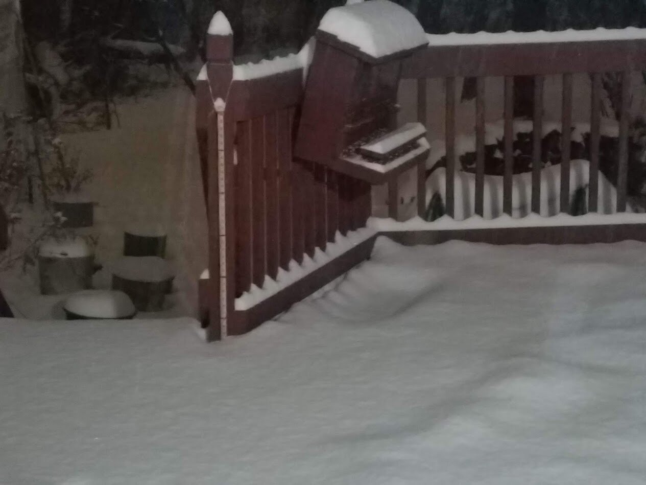
4 in here in macungie still snowing hard yard stick on the deck next to my squirrel feeder red marks are at 6 in increments

-
 almost 3 in here in Macungie PA still puking snow
 -
Bullseye. Walt. Hit the nail squared on from earlier last week. The tornadoes did occur in Fla. Now if the warm air would back off here LMAO. I cannot wait to see how bad the winds by tomorrow afternoon. https://www.foxweather.com/weather-news/tornadoes-tear-through-florida-neighborhoods-flip-vehicles-sunday
-
I was hoping to get that of response. Mesos are coming in with more snow like it
-
For the infamous Morning call and other media outlets. I have provided your media outlet with tomorrow's headlines since their headline in this mornings paper is : "Major winter storm downgraded" What a bunch of media sensationalists and will come back to bite them hard. Tomorrow's paper headline will say "A major overperfomer storm stuns Lehigh Valley drivers." Accidents were abundant as many roads were slippery as the salt and brine could not work very well with the initial temperatures of the surfaces near 20 degrees between 4pm and midnight last night. The snow could not melt quick enough as the late arriving snow continued to play havoc on the road surface. Even though it was a only small accumulation of snow and the plows are unable to drop the snow blades until three inches have fallen, many drivers refused to stay home and were lured into a false sense of security with their vehicles resulting in car accidents everywhere. There is your new title and summary Morning Call If I hear the term" over performer" again, I want to barf. This is some weather forecasters simplistic term created for simply explaining away the inaccuracies of their forecasting ability because they just do not know why . Just say I do not know why and I will research and get back to you on what I think went wrong. Thats what real scientists do. They learn from their mistakes. The media also uses sensational terms such as "double down, " influencer" etc , to hype a story that is failing in truth too. To the Morning Call----Meteorology is not journalism, it is a physical science. Get over it.
-
I agree but I hope that is not all sleet mixing in too
-
typical of a La nina year. The cold air is uploading over Canada right now with the clipper swinging through by the end of the week. Usually an App runner sets up the next big storm in this pattern along the coast. 1950 App runner storm was similar but this storm not as deep or as powerful.
-
Final call lowered my snow/sleet totals to 3-5 inches of snow/sleet in the LV. The wind fields have also been lowered to 40-55 mph wind gusts. Still expect about an inch of snow on the wrap around by Monday night. The big issue, lots of wrecks around the area tomorrow evening as the roads become quickly snow covered. Treating them will not help much in the first few hours as the snow will not melt right away. Otherwise the slush will refreeze Monday night as the roads will be too wet to completely dry out from the winds
-
well if the NAM verfies, there are going to be a lot of snow weenie suicides that's for sure. I can't even describe how awful the NAM is for snow lovers in PA. State College went from a foot to a few inches. Rain all the way to Syracuse after this deep cold is unreal. I have a meme just for tonights NAM Run
-
so far so good with my first call 24 hours later. Many models are tuning in to this scenario for the LV. My totals seem a little high but I guess that is what my second call will iron out tomorrow night. The third and final call will be Sat night Nam Run. Additional issues I see popping up now in the models: 1. More sleet at the mid levels are becoming an issue in all of the models. 2. The dry slot is still near or over the LV affecting snow totals before the changeover to sleet/frizzle. The front end thump maybe just a speed bump if the dry slot kicks our ass.. 3. If the wrap around snow does not come to fruition as the low races to the north because of the dry slot, then blowing snow will be curtailed as the sleet and frizzle put the "icing on the cake" to prevent blowing and drifting. Other than thundersnow, I really want to see howling blowing snow that causes drifting as it is a rarity in these parts from this event 4. lastly this inland runner could still go east by 50 miles or so by tomorrow night bringing a lot of happy faces to the I-95 people. Just have to model watch, especially the SREF and NAM runs as they are just outside their model trustworthiness right now. ++++++++++++++++++++++++++++++++++++++++++++++++++++++++++++++++++++++++++++++++++++++++++++++++++++++++++++++++++++++++++++++++++++++++ My second call this evening for this storm in the LV is by lowering my expectations of total snowfall to 4-6 inches under a winter weather advisory (Cannot meet the 6 inch winter storm warning criteria) then a changeover to one inch or more of sleet then to freezing rain .2 and then plain rain .4. Plain and simple gamut of wintry crap for sure for sunday night All of my previous concerns are still in play from my first call will be considered for incorporation of my final call tomorrow evening. The high winds from the expansive wind field with the double barrell low is concerning to me right now as that is a rarity in our area as well as in delay in the "kicker short wave from the Canada arriving late to the party which then may force the lp located off the SNJ coast to slowly become the primary with increased snowfall accumulations in the wrap around snowfall. Wind gusts over 65 mph will force the NWS in issuing a high wind warning in our region and occasionally near whiteout conditions in the wrap around snowfall is a distinct possibility. I simply call this the "Sandy" of the 2022 with the many power outages and tree felling throughout NJ especially as the soils will be super saturated from the quick thaw and heavy rain.
-
Central PA - Winter 2021/2022
Albedoman replied to Bubbler86's topic in Upstate New York/Pennsylvania
WTH. Does this guy know the definition of a blizzard? He needs to stop posting. -
well this NAM model run says it all for our snow chances in the video clip. No way if this keeps up
-
so far so good with my first call 24 hours later. Many models are tuning in to this scenario for the LV. My totals seem a little high but I guess that is what my second call will iron out tomorrow night. The third and final call will be Sat night Nam Run. Additional issues I see popping up now in the models: 1. More sleet at the mid levels are becoming an issue in all of the models. 2. The dry slot is still near or over the LV affecting snow totals before the changeover to sleet/frizzle. The front end thump maybe just a speed bump if the dry slot kicks our ass.. 3. If the wrap around snow does not come to fruition as the low races to the north because of the dry slot, then blowing snow will be curtailed as the sleet and frizzle put the "icing on the cake" to prevent blowing and drifting. Other than thundersnow, I really want to see howling blowing snow that causes drifting as it is a rarity in these parts from this event 4. lastly this inland runner could still go east by 50 miles or so by tomorrow night bringing a lot of happy faces to the I-95 people. Just have to model watch, especially the SREF and NAM runs as they are just outside their model trustworthiness right now.
-
yep I agree . Getting the hoses on and off the truck will be a hell of job too.
-
Have a question throw it my direction, glad to help