Albedoman
-
Posts
1,380 -
Joined
-
Last visited
Content Type
Profiles
Blogs
Forums
American Weather
Media Demo
Store
Gallery
Everything posted by Albedoman
-
popup showers 10% chance of getting one by this evening. All the main t-storm formation is again west of the Alleghenies- will never make it here by nightfall. Like I posted earlier this week , the drought will continue and get worse until a tropical storm breaks this crappy pattern for good and helps pulls down canadian cool air hopefully by the third week in september. Issues to contend with: 1. Leaves are scorched on many trees(sycamores, tulip poplars and maples ) and are falling like it is mid October. The summer web worm is also having a field day in Lehigh County and many walnut trees are becoming defoliated. making more leaves fall. Autumn peak colors will be like crap around here. 2. Stream base flows are falling big time . The 1-2 inch rain early in week helped only to temporarily green the lawns but did absolutely jack crap for the aquifers and stream base flows. 3. Overnight temps are killing us more than the daytime dryness. With no cool nights, we are not reaching the dewpoints and forming moisture on the vegetation and in the air. To make matters worse, the A/C is working overtime because no one can sleep when low temps are between the mid 60's and 70's 4. The current pattern will temporarily break on around Sept 1-2 and we will finally get lows to hit near the dewpoints of 45-50 degrees. But that will be only for a few days and then we are back into the SOS weather pattern.
-
finally a t-storm with lighting --- first one since June to hit me around 6 pm. received a little over an inch in the bucket. This was a million dollar rain for those farmers who got it to keep the corn from spiking and get the soybeans to produce pods again. Drought still not over as this rain was so torrential as it mostly ran off so quickly. Basically, the storm just washed the streets from the dust and debris and soaked the first inch of topsoil. By the end of the week , we will be back to square one with the return of the heat.
-
BS very localized storms in NJ . This picture means absolutely nothing. The rain gauge in Allentown PA must sit under a roof gutter LMAO then. 10-15 miles away from LVIA , places have received less than a quarter inch. Tell that to the farmers in western lehigh County This must be Allentown NJ. https://allentownnj.govoffice3.com/?pri=0
-
yep you are spot on- not forming in the Alleghenies/Valley but over the Blue Mts/Appalachians is always a good sign this early in the afternoon . Timing of the Ddurnal heating process is finally on our side of the state this time to form the heavy t- storms late this afternoon. We need a good band of training t -storms. I got less than .25 in of rain- no puddles in the streets late this morning. As I am writing this post it is pouring out side even for a minute. ----yippee a good sign
-
33.5 drops here in Macungie. Enuf to wet the brown blades of grass and make dirt spots on the cars for a few hours. Not even close to .05 an inch. The rain cannot even form a puddle on the road. The winner southern Mont county
-
The rain pitch was thrown, high and to the left a complete whiff- going up to Williamsport/ Hazelton in the past few hours and then dying- calling a ball. With 80% chance- how in the world do we even get that Mt Holly? I say right now the percentage is less than 20% of coverage in the entire forecast area. I am waiting for the wind up and pitch for the next potential at midnight --hope its a strike. If we get anything less than .50 an inch, I call drought warning for the entire area until a tropical storm hits us in the second week of September.
-
wow that's 39 drops more than me. I would say by tommorows mornings run, the precip chances will dwindle to 30% based on the short range models today. Its not looking good
-
wow, I have not seen a brick wall put up around the LV and points east for the formation of rain like the last two months. I got 20 drops last night- left some spots on the windshield of dust and pollen. The car instantly became so dirty again. The same areas are getting the rain right now - from York to points south and east and it is retrograding south and west. That 40% forecast of precip is for western Chester county only. All I can say if a tropical storm forms off the Carolina coast or northern gulf coast in September, there will be plenty of latent heat around here for it to stay strong.
-
everytime MT Holly calls for a 20% chance of t shower in the forecast period, this is how I feel
-
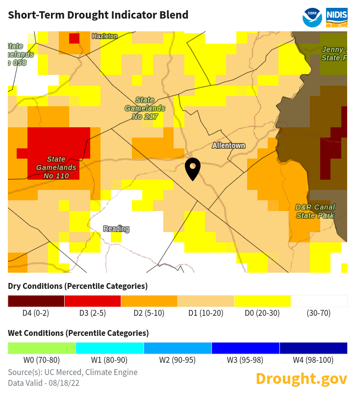
https://www.drought.gov/location/18062
-
This weather pattern sucks for sure. My yard is being destroyed. The garden stop producing and the we should be under a drought watch by the end of the week. No tropical development on the horizon that's for sure. I have had less than 2 in of rain since the beginning of June. The corn yields will be down big time.
-
precip on Monday is being ghostbusted . Precip chances dwindling by more than 10% each day. Not a real confident booster for sure. Each model run is being pushed further south and out to sea. Is this January 2022? Tropical season is not going to arrive until mid Sept this year for us.
-
I agree. Drought does not stop at the Delaware River just like flooding and a Nor'Easter.. The media takes a graphic and runs with it no matter how stupid it is. The USGS people need to wake up when doing public media for graphics. The media is too stupid to recognize the situation. https://www.drought.gov/states/Pennsylvania/county/Lehigh
-
forget about any rain for the LV. That Saharan desert dust is choking the living hell out of any precip forming north of I-78. That LP for Monday is also pee in the wind for anyone near i_78.
-
wow /less than .10 inch in three weeks at my house. These storms are so localized. The only savior will be a tropical storm. Today was a joke. It rained so little that the trees covering the road prevented the road from being wet. Mt Holly keeps pushing PWAT in their discussion like everyone is getting this in every local storm. no way. You would be lucky to get over .5 inch of rain. Time to rethink the pwat situation in the discussion. The storms are very short lived and blow themselves out in 20 minutes or so as evidence in the outflow boundary comments by other posters. I would be worried about PWAT if we had training storms- yet to see this situation this summer. I am afraid when the cold front comes through on Thursday- we will not see good rains for awhile. return back to early July weather cool and dry. The lawn will continue to burn up.
-
just received the million dollar rain. Almost an inch of water thus far from this storm. 2 million drops is my best estimate. Finally a t storm just for the LV on the radar. This will help hydrate those thirsty lawns, especially with the nitrogen as there was actual some lighting with the the showers
-
million dollar rain baby last night. .65 in of rain every little bit helps. Farmers are rejoicing in Southern Lehigh county
-
its coming. I expect a watch will be issued by mid - August unless we get a tropical storm. These hit and miss showers are good enough for farmers but not good enough to recharge the aquifers. The stream base flows are really starting to drop now as well. They were really high this past spring. The topsoil horizon is like powder in the shale soils and the clay soils elsewhere are starting to crack. The lawns are brown because they are primarily perennial ryegrass cool season grasses that are not heat tolerant as well as drought tolerant. The heat is browning the lawns even if they are watered sufficiently. The water tables are also falling rapidly in Lehigh county karst areas as the water is literally being sucked out from the water bottlers.
-
million dollar rain if its more than an inch. Yes its hopeful. The best chance in the last two weeks if it holds together
-
hit the forecast right on the nose. T storms redeveloping right around Philly. NWS discussion has left out the LV again of why we were screwed again.. What else is new. They are too worried about PWAT's in the forecast that do not even come to fruition. The 70% chance of rain has dwindled to 30% by 1:00 pm for the LV. I really do not see a measurable rain over one inch for the rest of the month. Normal for July should be around 4 in. Have had less than .25 in at my house. Drought watches coming soon. Current streamflow on the Little Lehigh is now in severe drought conditions. https://waterwatch.usgs.gov/index.php?r=pa&m=real&w=map
-
You can fire as many phasers (rain showers) at it and they just get absorbed in the dry shield around the LV. The line of t showers hits the LV and is done for. 20 drops at my house. Fricking unbelievable as the storm line separates again , goes south and north for the upteenth time this summer. Any storm line that hits the LV at 10 am is done for too All we get are stratus debris clouds from the storms with a few drops. By the time the line gets to philly area and south, they will be regenerating with raging t-storms again. The sun will come out soon and we will be in the 90's again with no heat advisory -typical screw job
-
Long shot thats for sure. Last week when had a t storm watch and 80% chance , less than 20% of the area got any precip and that was short lived. Its going to take a tropical wave/storm to break this stubborn pattern
-
The storm line struck the foul line pole near Walnutport and disappeared. Its like drying a wet spot on a shirt with a hair dryer. The rain disappeared within minutes in this desert air.
-
Oh I am here and watching. Keeping a low profile as seeing is believing for many posters. A back to back La Nina pattern for 2-3 years is killing this country right now. The evapotranspiration rate is a killer right now and it only going to get worse. The only way to break this routine is a tropical storm which will not appear until mid August or later. Hit and miss t storms with no chance of training is the norm right now. The base flow stream levels are dropping fast and I expect drought watches to be issued by the end of month. Here is the link for your perusal. We are in a moderate drought https://www.drought.gov/location/18062
-
Let the screw zone live on. What a fail. I was expecting a decent chance of a good t storm for the LV. It is fading real quick. That 80% chance of precip in the forecast looks more like 20% with the aerial coverage depicted on the radar right now. The .35 in of rain on Saturday was just enough to knock off the scorched leaves on my Kousa tree. It is going to real bad for lawns here by the end of the week.