Albedoman
-
Posts
1,321 -
Joined
-
Last visited
Content Type
Profiles
Blogs
Forums
American Weather
Media Demo
Store
Gallery
Everything posted by Albedoman
-
thanks. The time frame adjusted to ides of March then.
-
well, my 90 day forecast FWIW. Brutal ending to Feb. No more major snowfalls in Feb. Temps warm up above average. Precip- dry as a bone with occasional light rain showers with progressive cool fronts- nothing more than 1 in at the max March - only one decent chance for a major accumulating snow event. It will be the last hurrah and capper for this pitiful winter. Most likely to take place around the Philly Flower show time. Then it melts and Spring shows it face. Temps stay normal starting late March. Precip, dry as a bone except for this one major storm. Major pattern change opens up late in March to a -NAO April begins with the -NAO cloudy and cooler than normal before another new pattern change. After mid April, the stove turns on and dry conditions persist. I expect drought conditions to persist until the GOM opens up with t-storms. I expect a hell of season for early severe weather threats for the midwest, TN Valley and even the Ohio Valley as temps change drastically in mid April in the new pattern change.
-
this wildfire condition is only going to get worse as the month goes on. The snow hole and drought conditions continue. Last weeks heavy rain only served to temporarily wet the litter floor and flood the local streams with very little ground/soil water recharge since the soils were tightly frozen. The base flows in the creek will start to rapidly fall in the next few weeks as water usage continues to rise. However, the soil horizon is starting to thaw out in the last few days as soil temps finally rise. We really need a stationary front over us for a week with lows riding up the front to put a dent in this drought condition . I just do see that chance with this progressive pattern that is for sure. .FIRE WEATHER... An unseasonably mild day is expected today, with highs mostly in the 50s. Following a midday to early afternoon frontal passage, dew point and RH values are likely to drop this afternoon. Minimum RH values of 35 to 40 percent are expected across most of central and southern New Jersey, far southeast PA, and Delmarva. In addition, as a dry cold front moves through today, winds will become breezy, with westerly gusts near 30 mph expected. This combination could lead to a modestly elevated risk of wildfire spread this afternoon, mainly south of the I-78 corridor where there is no snow cover in place. Fairly similar temperature, wind, and RH conditions are expected on Friday, though that day should not be quite as breezy with southwesterly gusts up to 25 mph. The combination of marginal RH values and fuels not having had much time to dry following recent precipitation should preclude a need for any Special Weather Statements. However, we will be coordinating with state partners and will monitor for any changes. https://www.drought.gov/location/18062
-
long live that fricking donut hole. WE take this in the LV
-
give me the 70's and sunshine now. Time for night time t storms to track. This winter appears to be a huge letdown.
-
yep those pity flakes keep on falling. As I said before - Presidents day for the win. I see it on the models runs as they are choking on it now. They will get their act together in the next five days
-
well, that map really shows where the groundhog dug his hole in PA this year LMAO
-
my god the LR globals suck this morning and the GEM continues to donut hole us and give us the finger. I am ready for good time spring thunderstorms. This winter will go in the record books for sure as the year with no winter storm model consensus too. we could not even get pity flakes or just a few marbles of sleet last night in Macungie. The only things that happened from this storm event was heavier rainfall, the snow was gone in less than three hours, the temp gradient was remarkable from 39 to 60 degrees in four hours and during the night , the flash freeze did occur at sunset yesterday and finally the ski resorts will be in the red for sure.
-
yep since nearly 100% of the precip ran off directly into the streams
-
yep, I said that --Presidents day or bust is my motto. . Thats the usual MO of this type of progressive pattern we are in. I am sure the models will be flopping around on this possible storm event the next few weeks, especially if the AO goes into a real good negative territory at the same time. Coming out of a negative territory at the same time the LP forms makes sense for this time period and increase the chance that we actually might get a plowable snow event in the LV
-
Freezing at Williamsport, 53 degrees at my house. Wow, talk about a warm tongue of air? 150 miles makes a big difference. Its too bad we are on the wrong side all the time this year. I am glad we got some rain even though it just ponding on the surface ready to freeze solid by tomorrow night. The creeks are slightly out of their banks but that is because it is 100% runoff on frozen soils. It seems the rainfall and snow fall are useless right now except for the trout streams.. One thing I can really say however, the ski resorts are taking a royal ass kicking tonight. Many will probably shut down many trails early if the Valentines day storm chances busts
-
-
I was begging to say that. 10 days out on the GFS is just complete fantasyland at this point. GFS has been pushing back these storms every five days. I still think the Presidents day maybe promising before the next major pattern change and hoping the AO tanks
-
I agree with Iceman. This has been the mother of donut holes for the LV. The LV has been screwed every way it can in this pattern, north south east and west and every model today continued to show the continuation of that fricking donut hole in s central pa in the 10-15 day models. I will hope for a Presidents day storm event because that is all I see right now.
-
My Philly forum friends: Memphis Tn and eastern Arkansas is currently taking the brunt of this ice storm. Honestly, this maybe the worst ice storm they ever experienced since 1994 and maybe even worse than that. Here are some traffic cams from the link below. Its really bad already and the storm has just started. MLGW has had over 15,000 people without power in the past hour and if I was betting man, more than half of the city and metro area will be without power for days if not weeks. IMHO, this will be a catastrophic storm event for them the way it is panning out. There maybe a million people out of power for weeks down there. My sister in law still lives down there and two transformers just blew within the hour near her house. The media should be concentrating on this situation right now. https://www.localmemphis.com/gallery/weather/severe-weather/ice-storm-memphis-mid-south-1994-greenville-mississippi/522-aeadd648-43b4-425e-a9e7-856dfc8f17c9 https://buzzcam.net/MI40.html
-
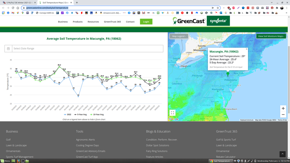
this is why I am concerned The surface temps are are way too cold and this is my proof. The rain and dense fog will not do anything as the it will be cloudy and fog sublimates the snow which affects the air temps and keeps the air much cooler. Weather model air temps do not accurately depict the entire picture of what the surface temps are. Many people will be surprised how quick the flash freeze will occur. This graph says it all
-
If that is indeed their concern, that is understandable. Thanks but Carbon and Monroe are under the fog advisory too? It comes down that Mt Holly really are still not sure on total ice accumulations. The confidence levels are not high for reaching winter warning ice accumulation levels but it is the flash freeze that changes the ball game. Thats my entire point and it should warrant at least a winter storm watch with mentioning in the watch that they are unsure of ice accumulations. . They can always drop it later periods.
-
FWIW, Mt Holly will likely have egg on its face by Friday evening. No way in hell do you issue winter storm watches for Carbon and Monroe in this current situation and not include the LV. You live by the model, you die by the model. The NAM has a known warm bias in this range and they should already know this. The GFS cold should not be ignored and the Euro/HRRR still have no idea on to handle this storm event. Physical Geography plays a huge part in this current situation and anyone who lives between the S Mts (the fall line) and Blue Mts will see ice. 30+ years of historical weather/ geography experience is telling me how this will unfold in this situation. The fall line plays a big part, plain and simple. We will most likely go a winter storm warning issued on Friday afternoon, too late IMHO. The sad thing there are going to be a ton of accidents, especially on the untreated roads because drivers simply ignore advisories and heed warnings and watches. You cannot stop four wheel vehicles on flash frozen surfaces and the drivers in our area have not seen this possibility in many years. The other sad issue is that ice accumulation under .25 inch does not affect most properties or damages trees. However .25 to .5 inch of freezing rain on a flash frozen road surface will kill people. Its time to be proactive and not reactive. By the time they issue a warning, the roads will be full of drivers, especially trucks. The trees however will still be standing. This is is not my first time seeing this scenario unfold. A simple winter storm watch would have sufficed. No body hurt. Enough warning to get people off the roads by Friday evening. Sorry for the rant
-
IMHO sometimes too much info in the pin point forecasting is dangerous. This is a fine example of this in this mornings forecast as seen below. Wording of the forecast leads to believe there will be no problem driving around the the LV. Could not be further from the truth. For one, I am real glad the rainfall totals are up there but this is 80-100% strictly runoff event and not getting into the ground and recharging as the ground is still frozen. All this winter storm event will do is raise the stream levels to bankfull and minor road ponding. Any thawing of the first few inches of soil will have the door quickly slammed shut and be refrozen by Saturday morning. Worst of all, it appears Friday evening into Saturday will be accident central in the LV spreading south as the roads freeze up quickly after the frontal passage and any snow and sleet that does fall will get compacted down. Going to be a real ice skating rink for sure. The big race will be on going to actually how fast PADOT can place salt on the road before it freezes. With no brining available because of the heavy rain potential, only immediate salt placement is going to help. Timing will be everything and I would not want to be driving anywhere early Friday evening around here, especially on the rural roads. Even though this may be only an winter advisory level event, I would recommend MT Holly at least issue a winter storm watch to get the public aware of this severe road surface icing potential. This is one storm event that MT Holly needs to be on the precautionary side and actually accept being in err on it not happening rather than take a wait and see reactionary attitude. Residents in our area have not experienced this flash freeze potential situation in a dozen years or so. Timing is everything. To sum it up, there are way too many party goers on Friday night around here and I think they will be surprised how quickly the roads will turn to crap. Thursday Night Rain. Low around 31. East wind 5 to 10 mph becoming west after midnight. Chance of precipitation is 100%. New precipitation amounts between 1 and 2 inches possible. Friday Freezing rain before 1pm, then a chance of sleet between 1pm and 4pm, then a chance of snow after 4pm. High near 35. North wind around 10 mph. Chance of precipitation is 100%. New ice accumulation of less than a 0.1 of an inch possible. New snow and sleet accumulation of less than a half inch possible.
-
 In this environment dealing with these chaotic weather models, this is my go to law firm:
-
I am so fricking tired of seeing almost every mid range model run in this progressive pattern showing the donut hole over the LV and LSV, no matter where the LP is situated , on the coast, as an App Runner and now an Ohio flyer. These models are so pathetic now and I have been doing this for 30 years. The combo of the NAM and Euro at 36 - 60 hours has usually been pretty reliable. This combo has even been an upheaval. This chaos is resulting in issuance of late warning or advisory events which causes more panic/weenism than anything else and the media hype is unbelievable. We have to create a better and definitely more reliable mid range model for proper guidance. Lets start by taking the avg of the GFS , Euro , GEM total precips and temps and actually calling it the RECON model instead of the worthless model called ICON. LOL
-
Central PA - Winter 2021/2022
Albedoman replied to Bubbler86's topic in Upstate New York/Pennsylvania
I lived and experienced driving through 1994, one ice/small snow storm event after another. Salt was in short supply. When 2-3 inches of sleet and freezing rain gets packed down on the untreated roads, its a losing battle , especially when it snows and temps drop into the teens for highs. The sun cannot melt the packed down icy surface. My main concern for this event is that a flash turnover from rain to freezing rain will occur for several hours then going over to heavy sleet. Valentines 2007 was a nightmare that I will never forget . I live a few miles from 78, on Rt 100. I got the hell off that road that afternoon and the sleet was literally glued to every surface imaginable. The PADOT policy of waiting until you get 2-3 inches of snow to drop the blade DOES NOT WORK with sleet. You must get that crap off the road and salt the living hell out of it to make it to a dough paste out of the accumulated sleet on the surface. Again I will stay with my thoughts above in bold. The current 18Z runs of the NAM are usually warmer at 60-84 and I expect they will become colder by tomorrow 12Z runs in this storm event. The Euro is trying to adjust and the GFS is still in the ball game with frontal positioning. Its basically all depending on HP strength and how quick and strong the LP develops in the lower Ohio Valley. We will have a good picture by Wednesday 0z runs. -
I would not trust the Euro right now- to wishy washy. The GFS has the right idea but way overdone. Somewhere in the middle - light rain to 4-6 hours of freezing rain/sleet then to wet snow for the LV. Very typical scenario for an "Ohio Valley Flyer" storm event. Usual results -- is a 4-6 inch snow event for us- higher snow accumulations near the Williamsport area . I also call this "salt drainer storm event" as municipal salt supplies can take a hell of a hit in a hurry for road treatment, especially if the cold hits hard afterwards. This upcoming pattern definitely reminds me of 1994 when I drove on snow/ice rutted roads for a week to work. I remember 222 / Hamilton Blvd was a complete mess where you actually had to drive along the curbs to find snow to drive on when you came to the intersections to stop as the rest of the intersection was packed down and rutted ice. The snow drought areas of Ohio should do well on this event too.
-
Central PA - Winter 2021/2022
Albedoman replied to Bubbler86's topic in Upstate New York/Pennsylvania
I posted this yesterday in the philly forum FWIW. I see no changes to my initial thoughts after the 12Z runs for the LV/Berks area. I would not trust the Euro right now- to wishy washy. The GFS has the right idea but way overdone. Somewhere in the middle - light rain to 4-6 hours of freezing rain/sleet then to wet snow for the LV. Very typical scenario for an "Ohio Valley Flyer" storm event. Usual results -- is a 4-6 inch snow event for us- higher snow accumulations near the Williamsport area . I also call this "salt drainer storm event" as municipal salt supplies can take a hell of a hit in a hurry for road treatment, especially if the cold hits hard afterwards. This upcoming pattern definitely reminds me of 1994 when I drove on snow/ice rutted roads for a week to work. I remember 222 / Hamilton Blvd was a complete mess where you actually had to drive along the curbs to find snow to drive on when you came to the intersections to stop as the rest of the intersection was packed down and rutted ice. The snow drought areas of Ohio should do well on this event too. -
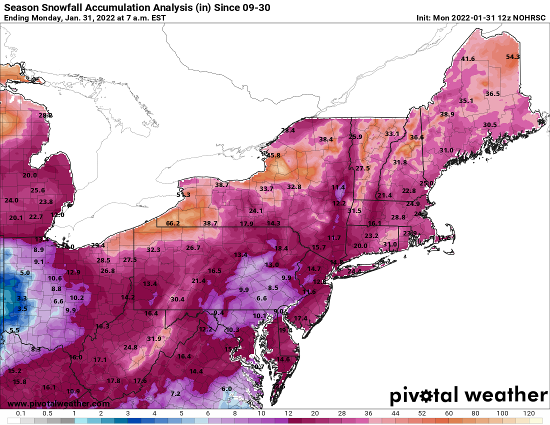
I would not trust the Euro right now- to wishy washy. The GFS has the right idea but way overdone. Somewhere in the middle - light rain to 4-6 hours of freezing rain/sleet then to wet snow for the LV. Very typical scenario for an "Ohio Valley Flyer" storm event. Usual results -- is a 4-6 inch snow event for us- higher snow accumulations near the Williamsport area . I also call this "salt drainer storm event" as municipal salt supplies can take a hell of a hit in a hurry for road treatment, especially if the cold hits hard afterwards. This upcoming pattern definitely reminds me of 1994 when I drove on snow/ice rutted roads for a week to work. I remember 222 / Hamilton Blvd was a complete mess where you actually had to drive along the curbs to find snow to drive on when you came to the intersections to stop as the rest of the intersection was packed down and rutted ice. The snow drought areas of Ohio should do well on this event too. Speaking of snow drought- can you see the donut hole for us in this map? truly amazing.