NEG NAO
-
Posts
8,610 -
Joined
-
Last visited
Content Type
Profiles
Blogs
Forums
American Weather
Media Demo
Store
Gallery
Everything posted by NEG NAO
-

Moderate snowfall 12/14/2025 WWA up for most of the area
NEG NAO replied to WeatherGeek2025's topic in New York City Metro
I think some areas will receive a few inches while others receive only a coating and this will turn into a nowcasting event and it's impossible to predict which area of the region will receive what amounts until the storm is approaching the region and in progress probably -
Moderate snowfall 12/14/2025 WWA up for most of the area
NEG NAO replied to WeatherGeek2025's topic in New York City Metro
Good luck with your first winter storm thread -
Can't believe all the complaining here and some folks saying we will never have a return to several above average snowfall seasons in a row here - - once again look at this history of NYC snowfall and try to explain it - we will return to above average snowfall seasons soon enough - its just that some of you younger folks have been spoiled by all of the much above average seasons since 2000........without a long stretch of much below normal seasons monthlyseasonalsnowfall.pdf
-
From my Neg NAO - AI: will it snow in new york city this weekend ? The perennial question that captures the imagination of every New Yorker during the winter months: "Will we get snow this weekend?" The prospect of a winter wonderland or a slushy mess always hangs in the balance, a fascinating interplay of atmospheric pressure, temperature gradients, and moisture content that keeps meteorologists on their toes. Regarding this upcoming weekend, December 12-14, 2025, it appears that New York City does have a chance of seeing snow, particularly during the overnight hours of Friday and Saturday. It won't necessarily be a major winter storm, but rather the potential for light snow or flurries as a series of weather systems move through the region. Here is a detailed breakdown of the forecast for your weekend: Friday, December 12th: The day itself is expected to be mostly sunny with highs in the upper 30s. The chance for snow arrives Friday night, specifically after midnight, when a clipper low may bring light snow or flurries to the area. The National Weather Service (NWS) is indicating a 30% chance of this happening. This is often a fast-moving system with limited moisture, so significant accumulation is unlikely at this time. Saturday, December 13th: Saturday is forecast to be mostly cloudy, with highs in the lower 40s. The weekend's second chance for snow will come Saturday night, as another system approaches. The NWS mentions a chance of snow after midnight, and some guidance models are even suggesting the potential for a more substantial system at this point, which weather experts are closely monitoring. Sunday, December 14th: A chance of snow continues into Sunday. Some reports indicate snow is possible on Sunday, with highs dropping into the low 30s. The key takeaway here is that while snow is in the forecast, the current predictions suggest a higher likelihood of lighter, nuisance-type snow or flurries rather than a disruptive, heavy snowfall event at this time. The exact accumulation amounts are still uncertain and highly dependent on the precise track of these weak systems. It is worth noting that New York City on average receives its first measurable snowfall around December 13th, so these systems are arriving right on historical schedule. It is important to remember that weather forecasting, especially concerning the exact type and amount of winter precipitation along the I-95 corridor, can be a delicate balance due to fluctuating temperatures that can turn snow into rain or vice versa. Forecasters use a variety of computer models and data to determine the most likely outcome, and predictions can be refined as the weekend approaches. For the most up-to-date and highly localized information as the weekend draws nearer, you should consult official sources like the National Weather Service (NWS) website or the city's official NYC Severe Weather page. Currently, there are no active winter weather watches, warnings, or advisories for the immediate New York City area. In conclusion, a definitive "yes" or "no" for a snow-covered weekend is difficult to state with absolute certainty right now, as the chances are present but not guaranteed. It's more of a "maybe, especially late at night." Prepare for the cold, as an Arctic air mass is settling in, but you likely won't need your heavy-duty snow shovel just yet. Keep an eye on those updated forecasts; they are the best tool for staying prepared in the ever-unpredictable world of New York weather! If you have any more questions about the specific temperatures or wind chills expected, please feel free to ask!
-
pretty soon we won't even have to post on here AI will post for us knowing what we would say and when we would say it
-
pattern doesn't support any storms in the northern stream to reach us still producing much- flow is too fast - in and out cold shots - have to wait till later in the month for the SOI to go further into negative territory and the southern stream gets more involved - then we have to rely on that 2nd advertised Strat warming event ..........
-
Probably - I still think when the advertised SOI starts to crash towards the end of December that's when the southern jet will begin to produce more wound up systems along with another Strat Warming Event the cold enough air will be available producing more frozen percip...........
-
And Upton and Mt. Holly are dismissing the storm all together with Sunny Skies......as of this evenings updates - NY NJ PA Weather agrees with this snow map........Who is a Weenie to believe ?
-
Christmas Eve 2025
-
Upton is downplaying the late weekend system - maybe some light snow friday night
-
-
what is a "tone" of snow "- ??? i don't think we'll worry about mid unless we are overhead " -- what are you talking about ????
-
12Z GFS and 12Z Euro Very Close
-
MJO is now in the Phase 8 COD - so other factors are having a larger influence on the weather models.........Also it seems that the MJO gets jammed up inside the Phase 8
-
Another positive signal Euro AI onboard- the Phase 8 MJO is now close to or into the COD so its weak not sure where it will be on the 15th - it is moving fast
-
it does look more promising as of 12Z today of at least a light to moderate event later in the weekend and maybe something light before that later in the week but for the late weekend system - it still is more than 5 days out so If it shows up starting at 0Z tonight I will get interested and it has to show up on more than 1 model . As for the "idiots" with the weenies just put them on ignore they are the ones which BX Engine mentioned yesterday in a post....
-
I am sure Virginia wasn't looking for average or above average snowfall and they are getting closer to it and its only December 8 - totally unexpected - could easily have happened around these parts = also these Clipper systems are not being handled well by the models or the arctic air - have to take them one at a time - this supposed warmup Christmas week is suspect too at this point
-
Upton has highs in Upper 20's remainder of today
-
are you talking about your area in Northwest NJ or the entire NYC metro from Ocean County up to Ulster County in NY ?
-
what are you going to do with the snowmans weenies ? Lets see if the storm shows up on the 0ZGFS and other models ? Or in 18Z we trust ?
-
first of all you know for a fact I am not gloom and doom all the time as we have agreed many times on here. Secondly the only guidance I can believe right now is what is being produced as of today - of course with borderline temps shown today can trend colder in coming days. And of course our time is probably coming as seasonal trends begin to favor more frozen solutions as we get deeper into the winter season.
-
Show us the guidance that shows that on the 12th
-
Borderline temps - could be similar to last weeks event - need any HP in southeast Canada to stay in place with blocking - not showing that yet - just a LP departing up there
-
would be nice if you explained what "patience" means to you ?
-
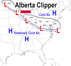
AI Overview Clipper weather refers to fast-moving winter storms, primarily the Alberta Clipper, which originate near Alberta, Canada, bringing rapid swings from cold to colder, light snow (1-3 inches), strong winds (30-50 mph), and biting wind chills as they sweep southeast across the U.S. Northern Plains and Great Lakes. While usually light, they can cause bigger snowfalls with lake-effect enhancement or if they intensify, sometimes becoming Saskatchewan Screamers or Manitoba Maulers (stronger variants). Key Types & Characteristics Alberta Clipper: The classic type, forming near Alberta, moving fast, bringing cold, wind, and light snow. Saskatchewan Screamer / Manitoba Mauler: More intense versions of clippers, often with more snow and stronger winds, developing over Saskatchewan or Manitoba. What They Bring Snow: Typically 1-3 inches, but can be 3-6+ inches, especially near the Great Lakes (lake-effect snow). Wind: Strong, gusty winds (35-50 mph) are common, leading to severe wind chills. Temperature: A noticeable and sharp drop in temperatures. Speed: Very fast-moving, often crossing regions in a day or two. How They Differ from Other Storms Colorado Low: Slower-moving systems that form in Colorado, often bringing much heavier, longer-lasting snow and blizzard conditions. Miller A/B Storms: Coastal storms that develop off the Southeast coast (Miller A) or the Gulf (Miller B), drawing significant moisture and potentially causing major Nor'easters, unlike drier clippers.