-
Posts
8,514 -
Joined
-
Last visited
Content Type
Profiles
Blogs
Forums
American Weather
Media Demo
Store
Gallery
Everything posted by NEG NAO
-
what are you going to do with the snowmans weenies ? Lets see if the storm shows up on the 0ZGFS and other models ? Or in 18Z we trust ?
-
first of all you know for a fact I am not gloom and doom all the time as we have agreed many times on here. Secondly the only guidance I can believe right now is what is being produced as of today - of course with borderline temps shown today can trend colder in coming days. And of course our time is probably coming as seasonal trends begin to favor more frozen solutions as we get deeper into the winter season.
-
Show us the guidance that shows that on the 12th
-
Borderline temps - could be similar to last weeks event - need any HP in southeast Canada to stay in place with blocking - not showing that yet - just a LP departing up there
-
would be nice if you explained what "patience" means to you ?
-
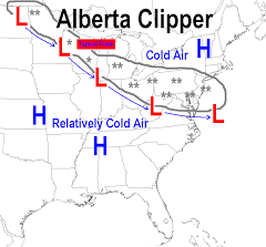
AI Overview Clipper weather refers to fast-moving winter storms, primarily the Alberta Clipper, which originate near Alberta, Canada, bringing rapid swings from cold to colder, light snow (1-3 inches), strong winds (30-50 mph), and biting wind chills as they sweep southeast across the U.S. Northern Plains and Great Lakes. While usually light, they can cause bigger snowfalls with lake-effect enhancement or if they intensify, sometimes becoming Saskatchewan Screamers or Manitoba Maulers (stronger variants). Key Types & Characteristics Alberta Clipper: The classic type, forming near Alberta, moving fast, bringing cold, wind, and light snow. Saskatchewan Screamer / Manitoba Mauler: More intense versions of clippers, often with more snow and stronger winds, developing over Saskatchewan or Manitoba. What They Bring Snow: Typically 1-3 inches, but can be 3-6+ inches, especially near the Great Lakes (lake-effect snow). Wind: Strong, gusty winds (35-50 mph) are common, leading to severe wind chills. Temperature: A noticeable and sharp drop in temperatures. Speed: Very fast-moving, often crossing regions in a day or two. How They Differ from Other Storms Colorado Low: Slower-moving systems that form in Colorado, often bringing much heavier, longer-lasting snow and blizzard conditions. Miller A/B Storms: Coastal storms that develop off the Southeast coast (Miller A) or the Gulf (Miller B), drawing significant moisture and potentially causing major Nor'easters, unlike drier clippers.
-
need one to dig more and slow down going south of us - these can give us 2-4 or 3-5
-
-
Only down to 19 here - no snow cover
-
First of all - Ocean County NJ should be in the Philadelphia region - and the farther north and west counties in NY and PA should be included in a new North and West Forum IMO. Variations in the weather conditions are too great from south to north and west in that map to be included in one forum (especially during the winter months)............But like I said before we have had this discussion previously and it is what it is.......OR we can set up the forums similar to the NWS does - Upton and Mount Holly - never could understand that concept...........
-
Would rather have snow the last week of December rather then the first week - many times when it has snowed early in the month it warms up towards the end of the month and its mild with no snow on the ground Christmas week .........last year was considered to be a "White Christmas" believe it or not with the little snow that was on the ground in most areas of the immediate metro...........This year the falling SOI and the fading LaNina supported by MJO in phase 8 should activate the southern jet BUT all the players on the field have to align just right to produce a snowstorm here........also another Strat warming event is going to unfold the second half of the month so this pattern should extend well into January.............
-
Belleayre should be considered to be Upstate NY not NYC Metro - I know we have had this discussion before - most of NYC metro doesn't look like mid-winter with most of us not seeing a flake yet........
-
Its only December 4th - our break will come soon enough - first chance early next week- for some reason here in north middlesex county nj they are spraying the roads with that liquid brine crap or whatever you call it again - never can be too careful I guess those water temps are causing the lower level to still produce liquid even with the upper levels cold enough for frozen close to the coast
-
as soon as the clouds start rolling in later the temps will stop falling and might even rise a couple of degrees towards morning.
-
when is the weekend storm thread going to start ? LOL
-
I would just stress in the headline the model guidance is not reliable especially past a certain number of hours - if that is the case - so folks won't get false hope - some storms there is no doubt we will end up with snowstorm region wide but these borderline situations have high bust potential regarding precip type especially- I still think there will be busts in the forecast for tomorrow one way or the other in certain areas yet to be determined. AI overview Meteorology is called an "inexact science" because the Earth's atmosphere is a massive, complex system that is impossible to measure with complete accuracy, and is governed by principles of chaos theory, making long-term, precise prediction impossible. While the underlying physics and math are precise, the application to predicting weather is limited by factors like incomplete initial data, the sheer scale of the atmosphere, and the amplification of tiny errors over time, a concept known as the "Butterfly Effect".
-
problem with indirect sun this time of the year is the very low sun angle-and whats with this area of snow this morning moving through eastern PA into NJ ? Will Tuesday mornings radar look similar to this mornings but surface temps lower Tuesday ?
-
Time is still on our side 2 days still till showtime...........I have been saying all along we have to wait till events unfold after that Great Lakes LP passes and how fast the HP sets up shop in southeast Canada and if it decides to stay put for awhile and how fast like you just mentioned the LP develops and moves in from the south its all in the timing
-
Its interesting that most people are dismissing the Euro and going with the worst models GFS-NAM Etc. The Euro snowfall map looks serious enough for the immediate metro to me for so early in the season . Oh Well !
-
that was an easier forecast because the arctic air was already established in place...........
-
what if the Canadian shifts back to its OZ accumulating snow solution ? And Euro shifts south ? there has been a wide range of differing model solutions in the last 24 hours from the amped GFS and Nam brings liquid all the way up to Albany and the Canadians 2 - 4 inches North Jersey
-
Models are confused right now to say the least - expect further changes in future runs ...........
-
now watch the next Euro's suite only bring the precip as far north as southern NY state - something is seriously wrong with some of these models..........is it GIGO (Garbage In/Garbage Out)??


