CheeselandSkies
-
Posts
3,347 -
Joined
-
Last visited
Content Type
Profiles
Blogs
Forums
American Weather
Media Demo
Store
Gallery
Everything posted by CheeselandSkies
-
Yeah, as I said hope those CPC precip outlooks posted in the spring LR thread verify, although would like to see green extending into even more of IA/WI/MN.
-

Spring 2024 Medium/Long Range Discussion
CheeselandSkies replied to IWXwx's topic in Lakes/Ohio Valley
Would like to see more of the AA precip chances extend into WI/northern IA/MN/SD, but I'll take EC. +temp/-precip is no bueno. -
Winter 2023/24 Medium/Long Range Discussion
CheeselandSkies replied to Chicago Storm's topic in Lakes/Ohio Valley
Don't give him any ideas. -
Still blew the daily record out of the water, but I don't think we'll get as warm as earlier thought (pretty sure I saw some 71s or 72s in the forecast) because we were expected to get more sunshine this afternoon.
-
Would beat 2/28/17 by a day, lol. https://www.spc.noaa.gov/products/outlook/archive/2017/day1otlk_20170228_1630.html
-
It's true that it's difficult for tornadoes and damaging winds to occur when storms are not surface-based, but the elevated significant hailer is very much a thing.
-
15Z HRRR started to downtrend the impressive supercells the earlier runs had across northern Illinois, and 17Z effectively loses them entirely.
-
That's true in a broad sense, but too much of a good thing is possible when you are dealing with shallow moisture.
-
When you have a relatively shallow low-level moist layer (only up to about 850mb or a little above at best on a couple soundings I just cherry-picked off this morning's 12Z 3KM NAM), vertical mixing (helped along by sunshine) can bring down that drier air, lowering surface dewpoints, thus raising LCLs (cloud bases) and possibly increasing low-level capping. At least, that's how I understand it.
-
A bit concerned about mixing issues with the full sunshine, SPC notes the same in their outlook especially WRT potential.
-
Yeah, that's a spicy run. If that stays consistent this morning, chase is a go. Sent from my Pixel 4a using Tapatalk
-
Yeah, I thought the same after today's 12Z HRRR run. 18Z seems to be an improvement although not quite ideal.
-
It's interesting, when they initially put out the Day 4-8 areal highlights on Thursday, SPC seemed pretty confident that moisture return would be less of an issue with this setup than would be expected for the time of year. What changed?
-
Yup, keeping an eye on it as posted above.
-
06Z GFS presents the area roughly near Ottawa-Streator, IL as a possible chase target. FH090 00Z sounding shows a stout low-level inversion but it ought not to be as strong during the preceding couple of hours. There's decent streamwise vorticity in the low levels and a solid westerly component to the 500mb flow. The higher-end scenarios with this setup don't look to be panning out at this point, but the atmosphere keeps trying to tell me it only takes one (storm) in the sweet spot.
-
A few flakes flying outside, but it's all melting upon contact on pavement.
-
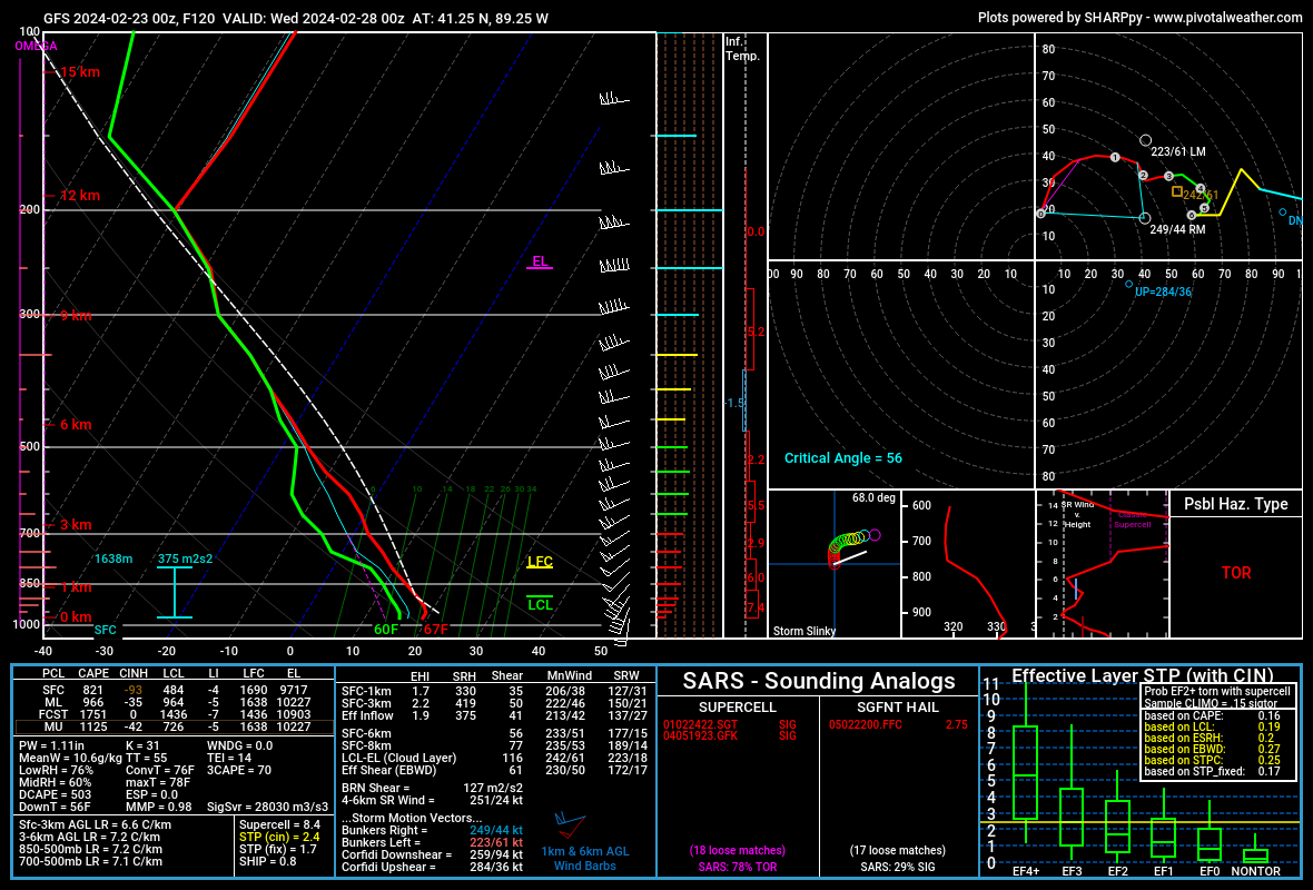
00Z GFS. Near Oglesby/La Salle, IL:

-
@andyhb with a nice succinct breakdown of why the models are having such a hard time getting a handle on this setup over in Central/Western.
-
Zero mention from MKX in the AFD or HWO despite SPC Day 6 risk going right up to the state line and plenty of model runs nudging the warm sector into the southern tier or two of counties at least. Meanwhile the mets at my work have already gone with a "First Alert Day" for Tuesday.
-
Just a few small, dirty piles/patches left on north-facing/shady embankments/hills or in parking lots where the plows stacked up the two January storms that comprised the bulk of our "winter." Reviewing my railfan pictures/video, that's quite a difference from five years ago today: Ironically, most of that cover likely was the result of the "clipper train" discussed in this thread:
-
Touched 60 in Madison today. Still some snow piles along north-facing hills/embankments. @madwx
-
Winter 2023/24 Medium/Long Range Discussion
CheeselandSkies replied to Chicago Storm's topic in Lakes/Ohio Valley
Not great to see but I will add the caveat that models, particularly the GFS, are prone to being excessively progressive at this range. If we do end up with a nice large wavelength trough, it shouldn't move that fast. -
Winter 2023/24 Medium/Long Range Discussion
CheeselandSkies replied to Chicago Storm's topic in Lakes/Ohio Valley
Yup. Also had the outbreak featuring the Marseilles, Washburn & Crossville EF3s and the Perryville, MO-Christopher, IL EF4. This on the heels of one of the more notable icing events in southern Wisconsin in recent memory (for me at least). We actually had enough accretion to noticeably weigh down the trees, and leave a clear glaze on everything even after the sun came out the next day. 2016 also had a relatively early season outbreak in the region; March 15th seemed about the earliest possible non-ridiculous time of year (remembering events such as 3/13/90 and 3/12/06) for this area to me so I went out and chased, got a glimpse of the Trivoli-Hanna City EF2. Of course, when the next year rolled around, late February just seemed way too **** early so I sat that one out. Apparently the lesson didn't stick because I also sat out the Winterset day in 2022 because I thought March 5th was too early, although in my defense that setup also looked rather marginal on most of the model runs in the days leading up to it. By the time it began to look genuinely good closer to go time, I had already talked myself out of chasing. Keota day last year was also quite early season for the region, but with it being a moderate/eventually high risk and the models consistently showing that (lack of) deep moisture return would not be an issue, confidence was much higher. Now of course in 2024 we get something truly stupid, with tornadoes in Wisconsin on February 8th, with dewpoints not even reaching 50, and one of those being one of the longest-tracked and most impactful in the south-central part of the state in nearly ten years (going back to the cluster of late-night strong tornadoes on June 16-17, 2014, when an EF2 missed my apartment building by about two blocks while I was staying in a hotel, having driven to eastern Nebraska to whiff on what turned out to be the Pilger event). Ironically, the least likely six-week period out of the year to get tornadoes in the Midwest in recent years seems to have become what should be the peak; May through mid-June. -
2024 Short/Medium Range Severe Weather Discussion
CheeselandSkies replied to Chicago Storm's topic in Lakes/Ohio Valley
There was another angle showing a pretty clear debris circulation with the one near Albany. Obviously the emphasis is on Evansville etc. today but I think there were likely at least two tornadoes with this storm. Edit: Juda/Albany supposedly already confirmed EF1 but I have yet to see anything on MKX's event page, a PNS or their Facebook page. May be yet another instance of someone on X stalking the DAT. -
2024 Short/Medium Range Severe Weather Discussion
CheeselandSkies replied to Chicago Storm's topic in Lakes/Ohio Valley
That's news to me. I always thought they were rated on the single most destructive thing they did.