

CheeselandSkies
-
Posts
3,370 -
Joined
-
Last visited
Content Type
Profiles
Blogs
Forums
American Weather
Media Demo
Store
Gallery
Everything posted by CheeselandSkies
-
Until someone explained it to me, whenever I would see that name posted I would think of former NFL cornerback Dominique Rogers-Cromartie because that's the only place I'd previously seen/heard that name.
-

Fall 2023 Medium/Long Range Discussion
CheeselandSkies replied to Chicago Storm's topic in Lakes/Ohio Valley
Possibly some potential in there somewhere, as well? -
Yeah, 2008 overall was a balls to the wall kind of year for both and in the Midwest. Occurring as they did in my young adult years it and 2010-'11 really upped my expectations for La Ninas which this recent stretch largely did not live up to. My dad was among those stuck on the Interstate on 2/6, on his way home from work.
-
2023 Short/Medium Range Severe Weather Discussion
CheeselandSkies replied to Chicago Storm's topic in Lakes/Ohio Valley
SPC Day 4 highlight for parts of IA/MN/WI. Don't see that in late October too often. -
...and beautiful.
-
2023 Short/Medium Range Severe Weather Discussion
CheeselandSkies replied to Chicago Storm's topic in Lakes/Ohio Valley
Had some interest in severe potential for tomorrow but it hasn't trended too impressively. Has some elements of a classic cold core setup with the moisture tongue getting pulled back into the TP, but just seems like the ingredients are out of phase on the models. All the flow is well out to the east in the warm sector, where there's no CAPE. -
That's surprising, considering the extremely prolific (and rather more impactful) outbreak that occurred over several days in November, 1992, tellingly dubbed "The Widespread Outbreak." Both 2004 and 2005 had quite active Novembers for (and, of course, extremely active and impactful Atlantic hurricane seasons) despite rather different ENSO states. They also had quite different springs for activity. 2004 might still be the best chase season this millennium for anyone who's been chasing that long, if they managed to score the storm of the day on May 12th, 22nd and/or 24th, 29th, and June 12th. 2005 had a mediocre to poor May, although it likewise featured a rather active period in the first half of June. I remember pulling up the University Corporation for Atmospheric Research site (Pivotal Weather didn't exist at the time, and I didn't know about the CoD site) on my dial-up connection and seeing that trough coming in on the 180-hour GFS frame. It still only goes out to 192 hours on that site!
-
2023 Short/Medium Range Severe Weather Discussion
CheeselandSkies replied to Chicago Storm's topic in Lakes/Ohio Valley
Despite meager instability forecast on the GFS, it wouldn't take much for something to happen near that triple point on Friday afternoon. Over E IA/N IL on the 06Z run. Main issue is and has always with this setup seemed to be the amount of precip the model breaks out across the warm sector. -
September 2023 General Discussion
CheeselandSkies replied to hardypalmguy's topic in Lakes/Ohio Valley
Last Saturday, September 30th I went up to the Wisconsin Rapids area for some railfanning. I neglected to check the forecast, assuming the forecast of sunny for Madison also applied to the rest of Wisconsin. Instead, thunderstorms moved in just as I was arriving, and lingered through the early afternoon. Me and my cameras got drenched, and it took until the mid-afternoon to finally get some nice sun-lit train shots. Consolation prize... -
That's amazing, considering this summer seemed pretty mild with no notable hot stretches (at least none that lasted more than a couple of days) to me in Madison, while Minneapolis, a place I think of as inevitably colder and snowier than us (like Green Bay, but soft, y'know, domed stadium and all), was so abnormally warm.
-
September 2023 General Discussion
CheeselandSkies replied to hardypalmguy's topic in Lakes/Ohio Valley
Yes we did. -
September 2023 General Discussion
CheeselandSkies replied to hardypalmguy's topic in Lakes/Ohio Valley
Remnants of Idalia didn't come anywhere near Wisconsin. It headed east back out over the Atlantic. -
September 2023 General Discussion
CheeselandSkies replied to hardypalmguy's topic in Lakes/Ohio Valley
Brendan used to work at the station I work at in Madison. Great guy. -
2023 Short/Medium Range Severe Weather Discussion
CheeselandSkies replied to Chicago Storm's topic in Lakes/Ohio Valley
Yeah, based on reports/photos that was a legit supercell with a brief tornado. Probably more impressive than anything that will happen in Iowa tomorrow, when it's actually in the tornado risk contours. -
2023 Atlantic Hurricane season
CheeselandSkies replied to Stormchaserchuck1's topic in Tropical Headquarters
Stalls it right on the coast, too, Florence-style. Yuck. -
2023 Short/Medium Range Severe Weather Discussion
CheeselandSkies replied to Chicago Storm's topic in Lakes/Ohio Valley
Yikes, that is downright nuts for Iowa Saturday evening. Late September is the new May? -
2023 Short/Medium Range Severe Weather Discussion
CheeselandSkies replied to Chicago Storm's topic in Lakes/Ohio Valley
I guess I'll be the one to dust off this thread, since no one else has. Day 4 outlook includes most of Iowa as well as portions of NE/KS/MO. Details/ceiling still pretty up in the air IMO. 06Z GFS also hints at further potential into the following week, but it's pretty much on an island with that. -
September 2023 General Discussion
CheeselandSkies replied to hardypalmguy's topic in Lakes/Ohio Valley
Yep, nice mood rain here tonight. My wife is back in the hospital for the sixth time since last December (we only got married in November of 2021). Unending complications from post-COVID kidney failure. Even if/when she does get a transplant, I'm no longer optimistic that she will recover to anything close to her former self. -
Whenever some Gen Z'er at work asks me if I'm on TikTok or Instagram, I tell them "It's bad enough I have a Facebook account." I had a Twitter account for about a year from 2017-'18, never once regretted deleting it. #OldFartMillennial Sent from my Pixel 4a using Tapatalk
-
2023 Atlantic Hurricane season
CheeselandSkies replied to Stormchaserchuck1's topic in Tropical Headquarters
Yesterday's 12Z Euro: Mega weenie run with Lee. GFS: Hold my beer. -
Category Five Hurricane Lee
CheeselandSkies replied to WxWatcher007's topic in Tropical Headquarters
New advisory has the forecast secondary peak down to 115kt. So much for that advisory from Friday morning that had Lee never dropping below 130kt through 06Z Tuesday 9/12. Not only the hurricane models but the multiple deterministic EURO runs and sub-910MB EPS members had my expectations sky-high for this one. -
-
Category Five Hurricane Lee
CheeselandSkies replied to WxWatcher007's topic in Tropical Headquarters
Every weather forum on the Internet would like to thank the 12Z Euro for the weenie run that was desperately needed to revive interest in Lee.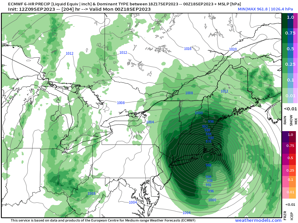
-
Category Five Hurricane Lee
CheeselandSkies replied to WxWatcher007's topic in Tropical Headquarters
In 2019/20, direct hits (landfall from the latter) from Humberto and Paulette caused fairly heavy damage, but no deaths and not enough to warrant retirement. Sent from my Pixel 4a using Tapatalk


