

George BM
-
Posts
2,610 -
Joined
-
Last visited
Content Type
Profiles
Blogs
Forums
American Weather
Media Demo
Store
Gallery
Posts posted by George BM
-
-
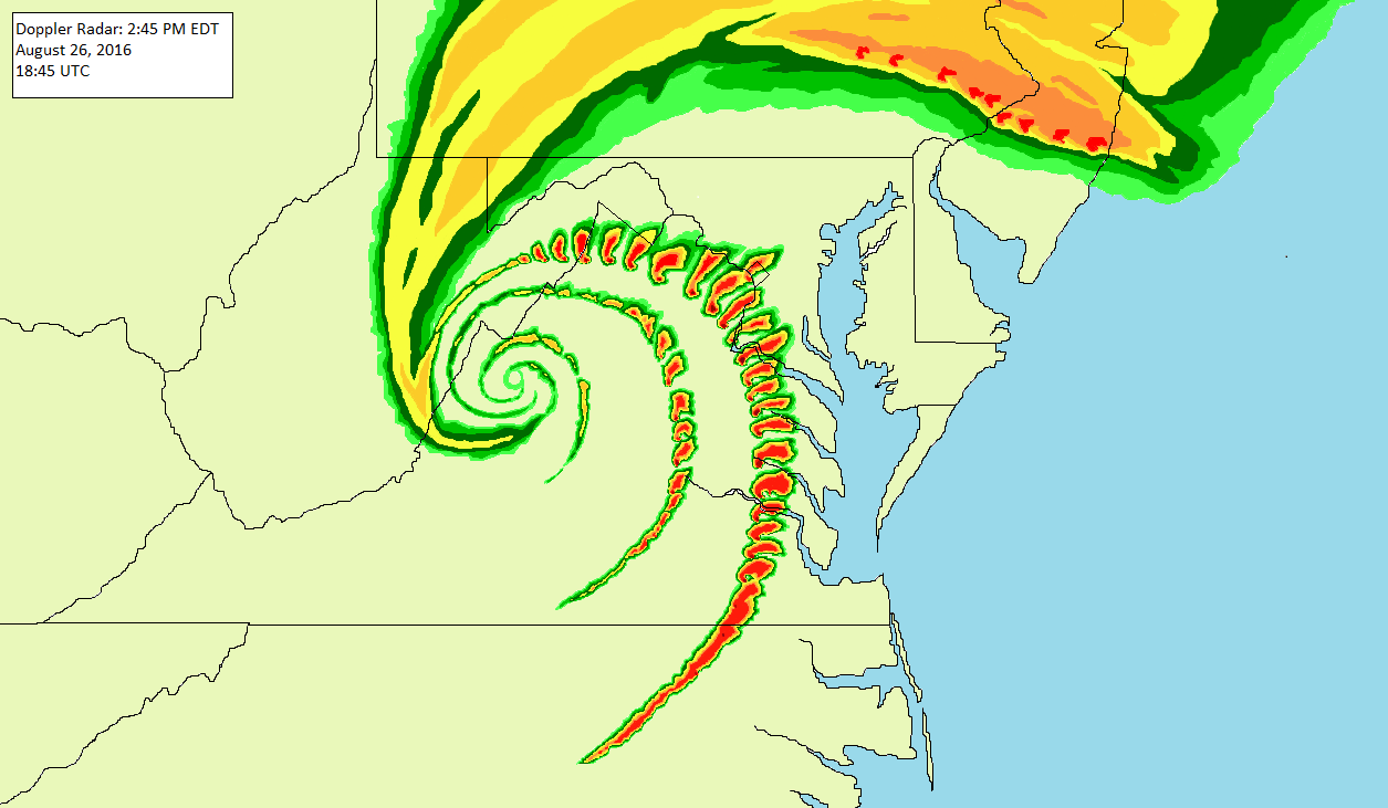
28.99" Hg at IAD.
-
7 minutes ago, WVclimo said:
Barometer at 29.03" and crashing here this morning. Been quite a while since I have seen a reading that low.
Yeah we should drop below 29" of mercury briefly. 29.05" at IAD currently.
-
URGENT - WEATHER MESSAGE National Weather Service Baltimore MD/Washington DC 930 PM EST Thu Feb 6 2020 DCZ001-MDZ003-011-013-014-016>018-503-504-506-VAZ052>055-057-505- 506-WVZ051>053-071030- /O.NEW.KLWX.WI.Y.0006.200207T1400Z-200207T2000Z/ District of Columbia-Washington-Southern Baltimore-Prince Georges- Anne Arundel-Charles-St. Marys-Calvert-Northwest Montgomery- Central and Southeast Montgomery-Central and Southeast Howard- Prince William/Manassas/Manassas Park-Fairfax- Arlington/Falls Church/Alexandria-Stafford-King George- Western Loudoun-Eastern Loudoun-Morgan-Berkeley-Jefferson- Including the cities of Washington, Hagerstown, Baltimore, Bowie, Suitland-Silver Hill, Clinton, College Park, Greenbelt, Laurel, Camp Springs, Glen Burnie, Annapolis, Severn, South Gate, Severna Park, Arnold, Odenton, St. Charles, Waldorf, Lexington Park, California, Chesapeake Beach, Huntingtown, Dunkirk, North Beach, Lusby, Prince Frederick, Germantown, Damascus, Bethesda, Rockville, Gaithersburg, Silver Spring, Columbia, Ellicott City, Dale City, Manassas, Woodbridge, Lake Ridge, Montclair, Reston, Herndon, Annandale, Centreville, Chantilly, McLean, Franconia, Arlington, Alexandria, Falls Church, Falmouth, Dahlgren, Purcellville, Leesburg, Ashburn, Sterling, Paw Paw, Martinsburg, Charles Town, and Shepherdstown 930 PM EST Thu Feb 6 2020 ...WIND ADVISORY IN EFFECT FROM 9 AM TO 3 PM EST FRIDAY... * WHAT...West winds 20 to 30 mph with gusts up to 50 mph expected. * WHERE...The District of Columbia, portions of central, north central, northern and southern Maryland, central and northern Virginia and the eastern panhandle of West Virginia. * WHEN...From 9 AM to 3 PM EST Friday. * IMPACTS...Gusty winds could blow around unsecured objects. Tree limbs could be blown down and a few power outages may result. PRECAUTIONARY/PREPAREDNESS ACTIONS... Use extra caution when driving, especially if operating a high profile vehicle. Secure outdoor objects. && $$
-
 1
1
-
-
4 hours ago, WxWatcher007 said:
We know one will succeed and the other will fail

Indeed.
...
Congrats fellow weenies throughout this subforum. Sorry about getting the fringey finger out there @psuhoffman.
-
1
-
-
67/36 at IAD 2:45pm est.
-
4 hours ago, Zanclidae said:
90s in March then!

Anyone remember March 01, 1980? Nice six inch snowstorm...
Then exactly a week later we were in the upper 70s, only snow remaining was the usual (snow) mountains in the shopping center lots. Some areas had severe, we got marble sized hail and a brief 50mph gust before it was all over.Neat. Was this at the same place that you lived during "The Spooky Scary Goose Whiteout" nearly 5 years later?
-
5 hours ago, Zanclidae said:
The reality of the matter is, it will be triple digit heat at midnight and all that will just dissipate into a few gusty thundershowers by the time it reaches 95.
2012 was a fluke for sure.
If you really want to see BIG storms and not move, the best best is move the mountains.

Imagine if the Appalachians weren't there at all and it was flat from the coast all the way to the Rockies. Now I think we'd see some weather, right?
Thing is with severe, even with decent lines, it's never a perfect line where everyone gets nailed. The 2012 Derecho was like that here. Lots of lightning but the real activity was to our south. And not far away either.
Our best (lightning) seems from cells that just happen to score a hit right overhead. Otherwise it seems to just fizzle out before reaching us. Maybe it's that Columbia Gas pipeline!
")
In any other case of severe potential that we’ve had in recent years around here I too would be cautious about jumping all in on a severe threat in these parts. But today is different… very different.
I very highly doubt that this line of storms will fizzle out or even weaken much at all as they move in. In fact, they may very well do the opposite.
Yes, legit severe is DEFINITELY extremely hard to get in these parts. But we are into the low/mid 90’s with dewpoints into the mid 70’s everywhere now. There is already a confirmed large tornado with the southern supercell, the northern Montgomery county supercell already has signs of strong rotation. Also, based on the 20z mesoscale analysis mid-level lapse rates are around 7.5C/km yielding MLCAPE of 4000+ J/kg everywhere.
The biggest thing for me to note is that low-level lapse rates are steep (near 9C/km) now. The main line of storms approaching from the west is steamrolling it east at around 65mph and is moving perpendicular to the flow. Now with those steep low-level lapse rates that I just mentioned downdraft winds will easily be mixed down to the surface. So, a lot of areas should see max wind gusts of at least 65mph. BUT… with decent downdraft CAPE as well (1000-1300+ J/kg) coupled with the very strong to extreme instability and high PW values (1.75”+) we could see strong downbursts bring down much stronger wind gusts on a more local basis.
Now as for the line of storms holding together through our region, effective bulk shear is strong for this time of year (around 50kts). This will allow the storms to remain very well organized and perhaps even strengthen a bit as the get east of the mountains and into the highest CAPE. Low-level shear is very decent for the time of year as well (effective SRH of 150-300m2/s2) hence the tornadic supercells developing ahead of the main line of storms. A few QLCS tornadoes are also possible with the main line.
This is the best that I’ve felt about a severe threat in these parts in a long time… perhaps even “ever”.
I just very glad that we finally seem like we’re going to score a bigly areawide severe event. Even work has brought @WxWatcher007 back to DC for this one.
However, RIP this afternoon's and evening's rush hour though.

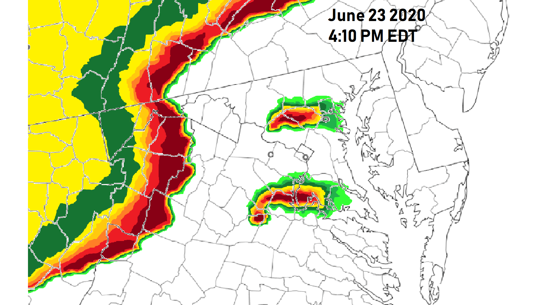
BTW, Here's the new 2000z Convective Outlook from NWS George BM headquarters:
2000z update
Mid-Atlantic region:
A few supercells have developed within the last hour or so affecting the WV panhandle, northern/central VA and northern MD. These storms could become tornadic with a strong tornado not out of the question given the 150-300m2/s2 effective SRH with very large hail and severe winds also a threat with these storms. The main line of storms associated with the severe MCS/derecho now stretch from PA through western MD and eastern WV and is now moving over the mountains and into northern and western VA and is moving east at around 55kts. This line may further strengthen as it moves east of the mountains into an airmass with MLCAPE of 4000+J/kg, 1000-1200+J/kg DCAPE and effective bulk-shear of around 50kts. Widespread severe winds w/ some significantly severe gusts, severe hail and a few QLCS tornadoes will be the main threat with these storms through the afternoon and evening hours before they all move out into the Atlantic by 2z.
Tornado: 10% (Enhanced)
Wind: 45% hatched (Moderate)
Hail: 30% hatched (Enhanced)
The threat for this upcoming Saturday also looks very decent for our standards especially near the MD/PA border. What a fun week of severe weather tracking.
-

-
 1
1
-
2
-
-
Woo storms!
31/28 at IAD.
-
2 minutes ago, losetoa6 said:
Put it this way. If I lived 300 feet below sea level on Assateague island with the wild ponies I'd still think it was silly to give up on Winter . While many were canceling the first 3 weeks of January I was shoveling on January 7th and then watching snow accumulation again on the 8th and then again on the 18th with a snow to ice storm . The thing is much of our frozen events are nickel and dime and occur in so so patterns or even hostile patterns and so called shutout patterns. Truthfully I don't look much past 8-10 days but casually. Once theres a threat..matter how low chance I start tracking that with only a brief look ahead . Plus...I have a passion for year around tracking ie.. ( flash flood events, tropical, severe ,locusts etc) . If it snows great..if not ...its ok ..it will again . Plus I have lots of other hobbies which include and not limited too..
Drinking cold beer
hot lil brunettes
Tearing up the street in my 87' GN
Watching baseball
Keeping up with 2 teen daughters
Jamming to lots of music
Running my electrical business.
Next year will be a-buzzin'!
-
1
-
-
5 minutes ago, psuhoffman said:
Game
Set
Match
Woo storms?

-
From last night.
-
@PrinceFrederickWx Lovin' it!
I'd be very curious to see these same graphs over the past 100+ years... or since record keeping began at the local airports.
-
 1
1
-
-
Is anyone going to try and see whether two dead satellites collide over Pittsburgh at 6:39pm est tonight?
The chances of a collision are very low (1/20-1/100) but still... maybe we may see something if they do collide.
They will be 560mi above Pittsburgh so you'd have to look up high.
-
1 minute ago, Sparky said:
Oops, I even forgot one somehow. Feb 2014 at least out in this area (25.5") was greater in total snow than the Feb 83 storm.
That storm had a super deathband with crazy rates early in the morning of the 13th. Probably comparable to the Feb 1983 storm... nah that storm had 5"/hr rates according to some and the Feb 1979 storm had 4"-6"/hr rates.
-
1
-
-
-
2 hours ago, Zanclidae said:
It's the ninth anniversary for the Jan 26, 2011 event. Completely caught off guard with that one. And like the Jan 25, 1985 whiteout, it seemingly came out of nowhere...
STORY TIME!
This was a two part event and generally forecast to come in with an advisory event and end as one.
In the morning there was enough snow to plow the lane clear. It ended as drizzle and clearing out the 3" or so of snow was typical slop that was expected.
After lunch, the radar showed some showers inbound and colder air was wrapping around with some sleet embedded. This was forecast change over to snow before ending with 2-4" forecast so the WWA was extended to midnight. No big deal and did not really watch things closely.
Then something different happened. Sleet was definitely pinging the skylights hard and to my surprise I got lightning alerts for strikes near Owings Mills, about 19 miles to my southwest. Radar echoes definitely showed sleet probability and maybe something else.Sleet continues up to dinnertime (around 1730) but seems to stop suddenly. Knowing what this usually means, I confirmed it changed over to snow. BIG flakes and really coming down. Great, going to have to plow after dinner.
After dinner I get caught up in something downstairs and about 50 min later a colleague of mine texts me asking if my power was out. I thought it was strange and replied no and checked the BGE map and over 50k customers were showing out! I ran upstairs to see about 3" of fresh snow and it was really coming down. I also heard the UPS' beeping and our lights were dimming. The peak number of BGE customers that lost power was over 230k, more than Sandy!
Went outside to start plowing and the sky was lighting up green to the south and east and seemingly everywhere. You know those eerie blue-green flashes of wires humming where downed limbs are causing million watt Jacob's ladders everywhere?
I heard cracking and crashes, branches everywhere were succumbing to the weight of this snow that was sticking to everything. Too dangerous to be near the Balsams and Spruces so I decided to wait it out.
Our gutters and fences looked like classic Jack Frost moments you see in Hallmark movies! Thousands of icicles six inches and longer everywhere. Running water from the rain and initially melting snow froze up nice.
We wound up picking up 16" total from that storm. Spent the next day digging out and using a track drive snow thrower as it was too much for my trip springs on my ATV plow. My back hurt from it but it was fun and memorable!
And (of course) the lights stayed on because we have backup power. Power line flashes are always fun to watch during ice and snow storms. That one was particularly memorable with the 60Hz humming. Almost War of The Worlds like!
A very cool story. Thank you for sharing.
How was the Jan 25, 1985 whiteout at your location?... How much lightning and wind was there with that event?
-
1 minute ago, Baltimorewx said:
I didn’t imagine you being that old either lol no disrespect
He isn't.
49/40 with rain approaching.
-
1 hour ago, MillvilleWx said:
It's a blast. Let me know if you want any tips or list of rides/places to eat. We had a great experience and rode so many great rides.
Which of those rides most reminded you about storm-chasing?
-
31 minutes ago, supernovasky said:
Y’all I’m really sorry. I moved here 4 winters ago and killed winter.
You'll be forgiven and then some if you can bring us our Category 5 up the Potomac.

-
40 minutes ago, psuhoffman said:
But it’s close day 10

Close indeed. Just get a slightly stronger push of warm and humid air and it could be a nice high shear/low cape convective event for some. Still have over a week for it to trend better..... or worse.
-
I feel..... young-ish?
I guess because I'm still fairly young-ish (early 20's) I get this preconceived notion that everyone who I haven't seen in person yet or who's general age I don't know is fairly close to my age.
I think there are just two posters that I know of on here (from what they've said) who are actually younger than me. *shrugs* I know there are probably more people on here who are aob my age who just don't post much.
Happy Martin Luther King Jr. Day.
-
1
-
-
-
1 hour ago, Eskimo Joe said:
The "we are due" index is pretty high in several areas specifically:
1.) Derecho
2.) Tropical system/remnants
3.) EF-2 or greater tornado
4.) Large scale river flooding event
Sooner or later the pendelum is going to swing back on us.
Maybe we get our dues all at once?

...
-
1
-

February Discobs 2020
in Mid Atlantic
Posted
Mesoscale Discussion 0105
   NWS Storm Prediction Center Norman OK
   0556 AM CST Fri Feb 07 2020

   Areas affected...northern VA...District of Columbia...central MD

   Concerning...Severe potential...Watch unlikely

   Valid 071156Z - 071300Z

   Probability of Watch Issuance...5 percent

   SUMMARY...Strong to localized severe gusts (50-60 mph) are possible
   with a narrow, low-topped convective band rapidly moving across
   northern VA and the greater D.C. area during the 12z-1330z period.

   DISCUSSION...KLWX radar imagery shows an intensifying band of
   low-topped convection with a few lightning flashes with the deeper
   convection exhibiting 20kft echo tops.  Surface analysis shows a
   surface low immediately northwest of D.C. developing to the
   east-northeast.  A narrow plume of weakly buoyant air, with surface
   temperatures in the upper 50s and dewpoints in the upper 50s, is
   located downstream of the convective band over northern/eastern VA
   into MD.  Objective analysis indicates around 250 J/kg SBCAPE with
   40 kt effective shear.  Given the strong, deep forcing for ascent
   co-located with weak instability, it is possible a few strong to
   locally severe gusts may accompany the bowing portions of the
   convective band.  The damaging-gust threat appears too confined in
   space/time to warrant a severe thunderstorm watch.

   ..Smith/Edwards.. 02/07/2020

   ...Please see www.spc.noaa.gov for graphic product...

   ATTN...WFO...AKQ...LWX...

   LAT...LON   39047766 39257701 39187648 38647665 38297716 37927819
               39047766