

George BM
-
Posts
2,618 -
Joined
-
Last visited
Content Type
Profiles
Blogs
Forums
American Weather
Media Demo
Store
Gallery
Posts posted by George BM
-
-
2 minutes ago, Kmlwx said:
0z HREF has ensemble mean 850mb winds of 75 knots around the area on Mon.
Even the long-range 6z hrrr (Yes, all caveats apply... end of range) shows 45-50 kt post-frontal gusts across the region. I usually find the hrrr more in line with what happens during synoptic wind events during the daylight hours. All long-range caveats aside... it looks windy tomorrow.
-
A rare Day 3 update.

Day 3 Convective Outlook AMEND 1
   NWS Storm Prediction Center Norman OK
   0211 PM CDT Sat Apr 11 2020
...Virginia through central and eastern Pennsylvania and New
   Jersey...

   Have expanded the SLGT risk farther north into this region. Areas of
   rain and thunderstorms will likely be ongoing north of a warm front
   from PA and NJ into southern New England. This activity will shift
   northeast during the morning allowing modest destabilization to
   occur in the pre-frontal warm sector with MLCAPE from 400-800 J/kg.
   Storms are expected to redevelop along cold front and in association
   with deeper forcing accompanying the northeast-ejecting shortwave
   trough. Wind profiles with 50+ kt effective bulk shear along with
   large 0-1 km hodographs will promote a threat for organized storms
   including supercells capable of damaging wind and a couple of
   tornadoes.
-
@losetoa6 Start the thread! I have a weenie feeling about this one.

-
 1
1
-
-
9 minutes ago, Kmlwx said:
Imagine getting this same system with 85 degree temps and 70 degree dews in a month or two...and better timing maybe.
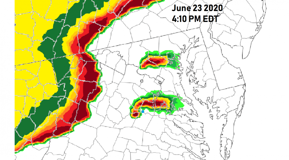
Psssst.... June 23rd is around the block.

-
Heads up seven up!


URGENT - WEATHER MESSAGE
National Weather Service Baltimore MD/Washington DC
813 PM EDT Wed Apr 8 2020

DCZ001-MDZ003>006-011-013-014-503>508-VAZ028-030-031-053-054-501-
505>508-WVZ052-053-090815-
/O.NEW.KLWX.WI.Y.0008.200409T1400Z-200409T2100Z/
District of Columbia-Washington-Frederick MD-Carroll-
Northern Baltimore-Southern Baltimore-Prince Georges-Anne Arundel-
Northwest Montgomery-Central and Southeast Montgomery-
Northwest Howard-Central and Southeast Howard-Northwest Harford-
Southeast Harford-Frederick VA-Warren-Clarke-Fairfax-
Arlington/Falls Church/Alexandria-Northern Fauquier-
Western Loudoun-Eastern Loudoun-Northern Virginia Blue Ridge-
Central Virginia Blue Ridge-Berkeley-Jefferson-
Including the cities of Washington, Hagerstown, Frederick,
Ballenger Creek, Eldersburg, Westminster, Reisterstown,
Cockeysville, Baltimore, Bowie, Suitland-Silver Hill, Clinton,
College Park, Greenbelt, Laurel, Camp Springs, Glen Burnie,
Annapolis, Severn, South Gate, Severna Park, Arnold, Odenton,
Germantown, Damascus, Bethesda, Rockville, Gaithersburg,
Silver Spring, Lisbon, Columbia, Ellicott City, Jarrettsville,
Aberdeen, Winchester, Front Royal, Berryville, Reston, Herndon,
Annandale, Centreville, Chantilly, McLean, Franconia, Arlington,
Alexandria, Falls Church, Warrenton, Purcellville, Leesburg,
Ashburn, Sterling, Big Meadows, Wintergreen, Martinsburg,
Charles Town, and Shepherdstown
813 PM EDT Wed Apr 8 2020

...WIND ADVISORY IN EFFECT FROM 10 AM TO 5 PM EDT THURSDAY...

* WHAT...West winds 20 to 30 mph with gusts up to 50 mph
  expected.

* WHERE...The District of Columbia, portions of central and
  northern Maryland, central, northern and northwest Virginia and
  eastern West Virginia.

* WHEN...From 10 AM to 5 PM EDT Thursday.

* IMPACTS...Gusty winds could blow around unsecured objects.
  Tree limbs could be blown down and a few power outages may
  result.

PRECAUTIONARY/PREPAREDNESS ACTIONS...

Use extra caution when driving, especially if operating a high
profile vehicle. Secure outdoor objects.

&&

$$
-
I like sardines.
-
 1
1
-
-
Just got some brief 35-40 mph wind gusts. Not much rain though as the line has really fallen apart.
Now if timing was 12 hours later or earlier...
-
8 minutes ago, midatlanticweather said:
Potential is definitely starting to show some focus. SPC highlighting Marginal next two days. HRRR going a bit crazy (notoriously).. We will see. Could be an interesting few days nonetheless.
The "obviously overdone severe-weenie" 6z 3kNAM said we get a supercell through DC tomorrow afternoon.
-
1
-
-
Just now, WxWatcher007 said:
Last member of the family is out of the hospital. Thank God.
Great news! May you and your relatives get through this time.
-
 1
1
-
-
8 minutes ago, Kmlwx said:
SPC indicates some potential for Wednesday.
A pre-climo NW flow regime w/ potentially steep mid-level lapse rates...
We watch.
-
1 minute ago, WxUSAF said:
Pretty sunset watch?
Warning... it's within one hour.
Northeastern areas will see the best sunset conditions.
-
Morning AFD from LWX. It's not often you hear this mentioned.
The 12Z KIAD sounding has winds 35-40KTS in the boundary layer
this morning. The inversion busted rapidly by 13Z across the
region, with numerous wind gusts between 30-40MPH in the western
suburbs of the Balt/Wash Metro Areas. Winds will temper a bit
this afternoon as the pressure gradient aloft slackens. Inverted
V soundings approaching super adiabatic, along with gusty winds
and dry surface conditions, you might see a dust devil or two
in the Shenandoah Valley during the midday hours.
-
3 hours ago, showmethesnow said:
Boy, that tornado is so huge and imposing that it makes the picture look almost surreal. Almost like it was a fake picture or something.
This! It looked even more unreal in person. Mother Nature can truly be amazing and humble the biggest weenies! This was one of my favorite pictures from the chase.
-
1
-
1
-
-
On 3/31/2020 at 11:15 PM, JakkelWx said:
Well, it's almost April 1st. Tomorrow, possibly the biggest April snowstorm for the DC - Baltimore and the Delmarva region is nearly certain to occur tomorrow, with over a foot of snow in northeast Maryland projected by the CRAS and the NAVGEM models. Buckle up people. We thought winter was over 2 months ago. At least it will be 60s and 70s right after the snowstorm for highs, marking the start of actual spring. Blizzard warnings have just been posted for much of eastern West Virginia, and the temps are in the upper teens here as of right now.
I got totally and utterly PUMMELED here! The snow started in earnest here during the morning coming down moderately heavily until about midday when it got dark and wind gusts suddenly kicked up to the 50 to 60 mph range out of the north with temperatures quickly falling from near freezing to the upper teens! The snow was blinding and I could not even see the end of my normally sized and not long driveway at several instances all afternoon! The snowfall rates had to be at least 4 if not 5+ inches per hour at times. Also, yes I heard thunder several times throughout the afternoon. I ended up with 25.2" of pure crystal joy by the time the snow tapered off near sunset. This was my favorite blizzard and I have no idea how no thread was made for it
 . Meanwhile it's still fairly windy here today with 30-40 mph wind gusts.
How much snow did you end up with over there and did you experience the same crazy rates, winds and thunder/lightning?
-
Just one of at least 11 EF5s during the 2020 Super Outbreak. This is near Fredericksburg, VA.
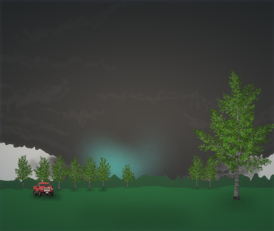
I'm the blue bot facing the tornado. This tornado was moving east at 60 to 65mph at this time.
-
2
-
-
@WxWatcher007 You and your family will be in my thoughts and prayers. Keep safe and well friend.
-
1
-
1
-
-
A chilly light drizzly rain.
-
What's your go to IPA during this time AND have your kids tried to get some of that good stuff?...
Go!
-
I haven't really stepped into this much vocally (there are lots on here that look way more indepth to this and have added some great info) but while the deceleration in the rate of the increasing number of daily new cases is a good thing to see... that might just be that only so many people are being tested in a day. I mean we all know that there are probably millions who already have it (I know... not exactly big news (limited testing availability)). But the daily death rate is probably more representative of how things are shaping up here.
This, of course, is just my opinion.
-
2 minutes ago, nj2va said:
Balmy 74 in Deep Creek.
...With fairly decent storms to the north.
-
Just now, high risk said:
1500 is probably enough cape to handle that kind of instability, especially given that it's not "tall, skinny" cape, and there is enough low-level instability for good parcel accelerations. The forecasted soundings keep getting better, and SPC now has a day 2 MDT which looks justified. Still questions about evolution of elevated convection earlier in the day and resulting impact on how far north the warm front can get, but areas just south of wherever the warm front ends up look primed.
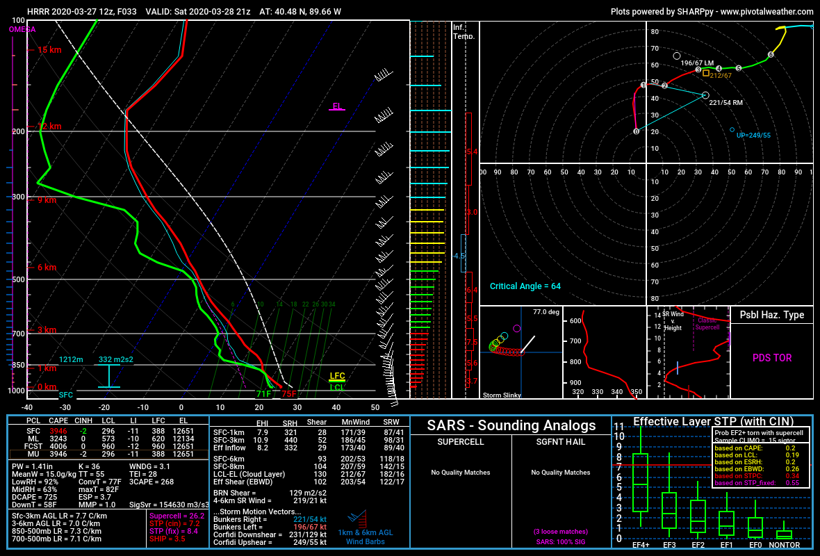
Thank for the reply. Yeah the latest long-range HRRR has some loltastic soundings. I mean check out this uncontaminated sounding below. I mean 3,000+ J/kg MLCAPE, LI near -10 with effective bulk-shear around 100kts. Lol!

-
55 minutes ago, yoda said:
Looks like our first chance in a while of some thunderstorms, maybe even an isolated severe threat is on Sunday afternoon
Now this is not for our region (SW of Chicago)... AND it's just one run from last night's 0z NAM at range but... it's not too often that you see 100+ knot EBWD with 1,000+ J/kg MLCAPE.
(Also, please ignore the fact that I accidentally called these files as the 3kNAM... the images below are actually from the lower-res NAM)
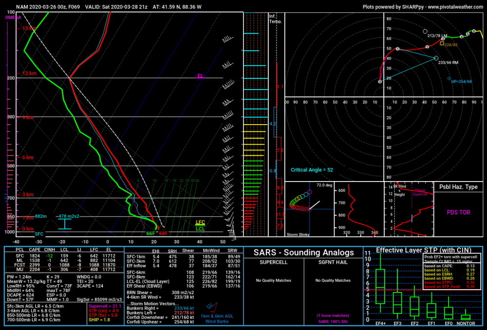

The following is just me thinking out loud. I'm not making assumptions about the severe threat over yonder.
I wonder if 1,500+ J/kg mlcape and LIs of -5 to -6 would be enough instability for storms to not get ripped apart by this kind of shear verbatim (Is CAPE fat enough?).
Yeah 1,500 J/kg mlcape is not all that weak but... that shear though...
Of course I'm not trying to take away from the high-ceiling that storms will have should they take advantage of their environment.
@high risk @csnavywx thoughts on this?
Also I realize now that I have a problem with using too many ellipses and parentheses.
-
MD schools closed through April 24th.
-
21 minutes ago, nw baltimore wx said:
I didn’t get to the yard today but my gf and I did a nice walk/hike on the Red Run trail in Owings Mills. Very quiet and peaceful. It was very easy to maintain a safe distance from the 10-20 people we saw over the course of an hour.
Cushwa Fog at Daybreak as a reward.
Yesterday I went for a walk around my neighborhood and I've never seen so many people/families out and about just walking. Obviously the 80 degree Fahrenheit weather had a big hand in that.
I kept a safe distance from others.


2020 Mid-Atlantic Severe Weather - General Thread
in Mid Atlantic
Posted
I know that the post-frontal winds may be strong but... though we are not expecting much of this atm pre-cold front can you imagine if we somehow got a break in the clouds late tomorrow morning with those kind of low-level winds overhead?... Of course this is more speculative than me predicting it.