

George BM
-
Posts
2,610 -
Joined
-
Last visited
Content Type
Profiles
Blogs
Forums
American Weather
Media Demo
Store
Gallery
Posts posted by George BM
-
-
32F with rain and 0.04" of ice accretion on the trees.
-
1 minute ago, WinterWxLuvr said:
Why do people say “the DMV”?
DC, Maryland, Virginia.
-
Snow started just after 6:05am and became moderate/heavy within ten minutes. Fine small flakes. It's tapering off now. Herndon, VA.
-
2 hours ago, BTRWx's Thanks Giving said:
I thought there was specific criteria that has to be met.
eta: https://www.weather.gov/lwx/WarningsDefined#Winter Weather Advisory "
Winter Weather Advisory
A Winter Weather Advisory will be issued for any amount of freezing rain, or when 2 to 4 inches of snow (alone or in combination with sleet and freezing rain), is expected to cause a significant inconvenience, but not serious enough to warrant a warning.
If the event is expected to impact the Baltimore/Washington metro areas during rush hours (4-9 am or 2-7 pm on weekdays) forecasted snow totals of one inch will necessitate the issuance of a winter weather advisory. The snow/sleet criteria for a Winter Weather Advisory for the five westernmost counties (Allegany, Mineral, Grant, Pendleton, and Highland) is higher (3-5 inches).
"
There is the potential for some ice accretion.
URGENT - WINTER WEATHER MESSAGE
National Weather Service Baltimore MD/Washington DC
133 PM EST Fri Jan 17 2020

MDZ503-504-VAZ028-030-031-052-053-501-502-505-506-WVZ052-053-
180245-
/O.NEW.KLWX.WW.Y.0003.200118T1200Z-200119T0000Z/
Northwest Montgomery-Central and Southeast Montgomery-
Frederick VA-Warren-Clarke-Prince William/Manassas/Manassas Park-
Fairfax-Northern Fauquier-Southern Fauquier-Western Loudoun-
Eastern Loudoun-Berkeley-Jefferson-
133 PM EST Fri Jan 17 2020

...WINTER WEATHER ADVISORY IN EFFECT FROM 7 AM TO 7 PM EST
SATURDAY...

* WHAT...Snow, sleet and freezing rain expected. Total snow and
  sleet accumulations of up to one inch and ice accumulations of
  up to one tenth of an inch.

* WHERE...Portions of central Maryland, northern and northwest
  Virginia and eastern West Virginia.

* WHEN...From 7 AM to 7 PM EST Saturday. Precipitation will begin
  as snow before transitioning to sleet and freezing rain.
  Precipitation will change to rain late in the day.

* IMPACTS...Plan on slippery road conditions.

PRECAUTIONARY/PREPAREDNESS ACTIONS...

Slow down and use caution while traveling.

When venturing outside, watch your first few steps taken on
steps, sidewalks, and driveways, which could be icy and slippery,
increasing your risk of a fall and injury.

&&

$$
Hope that helps.
")
-
IAD just gusted to 44kts.
-
2 minutes ago, jaydreb said:
I guess we just got NAM’d? Or are we still waiting for a better NAMing?
Yes.
-
22 minutes ago, PrinceFrederickWx said:13 minutes ago, frd said:
I forget what recent year it was, it may have been 2017 come to think of it , definitely one of the last 6 or 7 winters. The tracks were almost ideal , favoring snow, but the cold air was stale and the confluence never held. Not sure what the cause(s) were, but it lasted a good part of the winter. There were even issues far to the NE as well into New England as well.
I thought we had a coastal that looked like this in late January 2017 with a very similar setup that did indeed end up being all rain. I may have the year wrong though.
Monday January 23, 2017.
It was the one year anniversary of the 2016 blizzard and there was moderate to heavy rain with fairly strong winds through the first half of the day. Far NW areas changed over to frozen (mainly sleet iirc) and got some minor accumulations.
And also, yeah, I remember a NWS disco out of ME or New England with very "irritated sounding" wording about it being late January that year yet not being able to get much in the way of any snow.
ETA: Could have sworn I was in banter... sorry about that.
-
 2
2
-
-
Yes. Around midnight last night the visibility here in my neighborhood in Herndon, VA dropped to near Valentine's Day 2015 snow squall levels.
-
3 minutes ago, MillvilleWx said:
I remember an event back in 2015 after we had a long stretch of sub freezing days at Millersville, we had a touch of snow to sleet and then ZR. We actually had 0.1” accretion while temps hovered between 32-34F. It was incredible to see ice build up on the ground above freezing. There’s a lot to ZR and the physical process of ice. It’s actually quite fascinating.
.Yes. The same thing happened with the early January 2018 ice event right after the coastal scraper and following cold wave that kicked off the year. Ice accretion all over the driveway at 33+F.
Quite fascinating indeed.
-
8 minutes ago, yoda said:
00z GFS laughs at us again for next weekend... coastal comes... but no cold air
The run wasn't sufficiently cold.
-
 1
1
-
-
20 minutes ago, MillvilleWx said:57 minutes ago, leesburg 04 said:Freezing rain at 32 isnt a thing...just sayin
It’s certainly not as efficient, but it can still be ugly when the antecedent conditions leading in are pretty cold. A lot of the surfaces will remain solidly below freezing despite air temp being at freezing. Urban areas will have a harder time with accretion, but out to the north and west, it’s probably closer to 30 and really uglyYeap. 0.03" of ice actually managed to accrete on tree branches at 32F with light rain/drizzle IMBY through the afternoon and evening following the nearly 5" of snow earlier in the day. This was the February 20th, 2019 event.
-
16 minutes ago, smokeybandit said:
OK, which one of you broke Tropical Tidbits?
Sorry about that.

In all seriousness though: So it's not just me. Good... Well not good but you get what I'm saying.
-
8 hours ago, MillvilleWx said:
Man, there's a few good storms in there. One of my all time favorite, extremely underrated storms was 2/9/2006. Got absolutely buried by a crazy deformation axis that extended from NoVa to just north of NYC. The reason people actually remember that storm was due to thunder snow in the band, and the fact it warmed up so fast after the storm exited. I remember it was in the 40's before Noon just north of Baltimore. Crazy, but some of the greatest rates I've ever seen.
3 hours ago, jayyy said:I lived 30 miles NW of NYC Along the Hudson River in ’06. 2/9/06 was an UNREAL storm. 20+‘degree temp drop and almost a foot of snow in mere hours. Insane.
Yeah. That 2/11-12/2006 storm was a mashed potato boogie woogie.
-
59 minutes ago, PrinceFrederickWx said:
So to recap this day for the last four years at BWI:
2017: record high of 70
2018: high of 63
2019: snowstorm starting!
2020: record high of 70 again
This. I've noticed that since 2017, January 12th just wants to be near 70F in the region... other than last year's reprieve of course.
-
1
-
-
Aaaaaaaand I slept through the squall line because I chose the best time to have a throbbing migraine... it was even interfering with me watching 'The Rise of Skywalker' with my brother yesterday evening.

It was a good movie though.
-
Aaaaaaaand I slept through the squall line because I chose the best time to have a throbbing migraine.
62/42 at IAD now.
-
Currently 70/57 at KIAD.
-
Record Highs for January 11th:
DCA: 75F / 1975
BWI: 73F / 1975
And in case you're curious...
IAD: 71F / 1975
-
9 minutes ago, mappy said:
I love this! My bestie made me a tornado cake for my 30th (years ago)
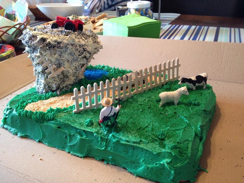
I love the farmer just guarding his turf.
Farmer: *Points pitch-fork at the tornado* "FREEZE you diseased rhinoceros pizzle!!"
-
1
-
-
20 minutes ago, PrinceFrederickWx said:
My wife made this cake (the "hurricake"!) for my mother's birthday- my mom's wanted a category 5 up the bay her entire life, well now it's happening!
(My mom is the biggest tropical weenie you will EVER see, by the way)

A category 5 hurricane up the Potomac and dead over my house?! Paging @Bob Chill.
Oh yeah!! Uh huh!! Oh yeah!! Uh huh!! Oh yeah!!
-
 1
1
-
-
8 minutes ago, mappy said:
suns out. 1" new from that squall. more dropping south out of PA
Over how many minutes did you receive that inch?
-
-
-

January Banter 2020
in Mid Atlantic
Posted