George BM
-
Posts
3,015 -
Joined
-
Last visited
Content Type
Profiles
Blogs
Forums
American Weather
Media Demo
Store
Gallery
Posts posted by George BM
-
-
Probably pea-sized hail- uhh
 I mean sleet over the past 10-15 minutes in Herndon w/ some flakes mixing in around 10am.
-
Snow mixing in w/ the sleet now in Herndon.
90/10 sleet/snow.
-
29/12 at IAD.
-
-
On 2/8/2021 at 8:53 AM, George BM said:
Dec 7,9,14,25/2020: T
Dec 16-17, 2020: 2.1"
Dec 18, 2020: 0.2"
Jan 5, 2021: T
Jan 18, 2021: T
Jan 20, 2021: 0.1"
Jan 25-26, 2021: 0.2"
Jan 31- Feb 3, 2021: 5.0"
Feb 4-5, 2021: T
Feb 7, 2021: 2.4"
Total as of Feb 8, 2021: 10.0"
Dec 7,9,14,25/2020: T
Dec 16-17, 2020: 2.1"
Dec 18, 2020: 0.2"
Jan 5, 2021: T
Jan 18, 2021: T
Jan 20, 2021: 0.1"
Jan 25-26, 2021: 0.2"
Jan 31- Feb 3, 2021: 5.0"
Feb 4-5, 9/ 2021: T
Feb 7, 2021: 2.4"
Feb 10-11, 2021: 0.4" snow/sleet
Feb 13, 2021: 0.2" sleet
Total as of Feb 15, 2021: 10.6"
-
Looking at soundings for late tonight - pre-dawn tomorrow, with some elevated instability I wouldn't entirely be surprised if a few heard thunder especially east of I-95.
-
Well... looking at soundings for late tonight - pre-dawn tomorrow, with some elevated instability I wouldn't entirely be surprised if a few heard thunder especially east of I-95.
#SOON
#Aroundthecorner
-
1 minute ago, Chase said:
Anybody got a good regional radar link? I hate the NWS’s site.
https://weather.cod.edu/satrad/nexrad/index.php?parms=LWX-N0Q-1-48-50-usa-rad#
-
 2
2
-
 1
1
-
-
Knock yourselves out.
https://www.spc.noaa.gov/exper/outbreaks/#
See you on the flip side when you're out of the wormhole.

-
 1
1
-
-
23 minutes ago, SomeguyfromTakomaPark said:
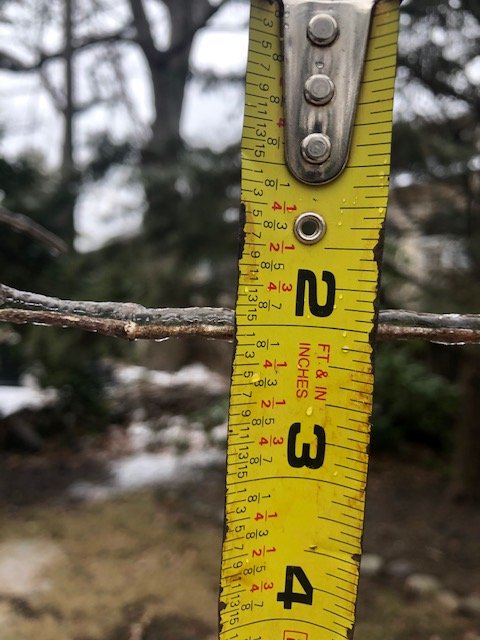
IIRC, and don't quote me on this, the guidelines for measuring ice accretion is taking the average of the amount of ice on top of a twig and below the twig. Ex: 0.12" ice accretion on top of the twig and 0.02" of ice visible below the twig gets you 0.07" of ice accretion (0.12 + 0.02)/ 2
I'll double check though.
-
Sleet here. Hopefully it will change back to ZR in due time.
28/23 at IAD.
-
1 hour ago, dailylurker said:
If we're going to have boring a$$ freezing rain I hope it at least causes some destruction. What good is ice without crashing and booming. I hope people don't get hurt of course but I wouldn't mind some tree damage. Free firewood and I can charge to remove it. Let's face it. Most of us are here for extreme weather of any kind.
Indeed! I mean Bob Chill has been waiting for his foot of ice. For me an ice storm w/ at least one inch of ice accretion would be nice. Afterwards, hopefully we can score a legit areawide severe event and/or decent tropical event.

-
 1
1
-
-
On 2/4/2021 at 9:17 AM, George BM said:
Dec 7,9,14,25/2020: T
Dec 16-17, 2020: 2.1"
Dec 18, 2020: 0.2"
Jan 5, 2021: T
Jan 18, 2021: T
Jan 20, 2021: 0.1"
Jan 25-26, 2021: 0.2"
Jan 31- Feb 3, 2021: 5.0"
Total as of Feb 4, 2021: 7.6"
Dec 7,9,14,25/2020: T
Dec 16-17, 2020: 2.1"
Dec 18, 2020: 0.2"
Jan 5, 2021: T
Jan 18, 2021: T
Jan 20, 2021: 0.1"
Jan 25-26, 2021: 0.2"
Jan 31- Feb 3, 2021: 5.0"
Feb 4-5, 2021: T
Feb 7, 2021: 2.4"
Total as of Feb 8, 2021: 10.0"
-
11 minutes ago, NorthArlington101 said:
NAM sucked for CHO and this Super Bowl sucks. Bad few hours.
not that I believe the NAM
... and even if you do, the boundary was dropping south at the end of the run. You were about to flip to wintery precip.
-
 1
1
-
-
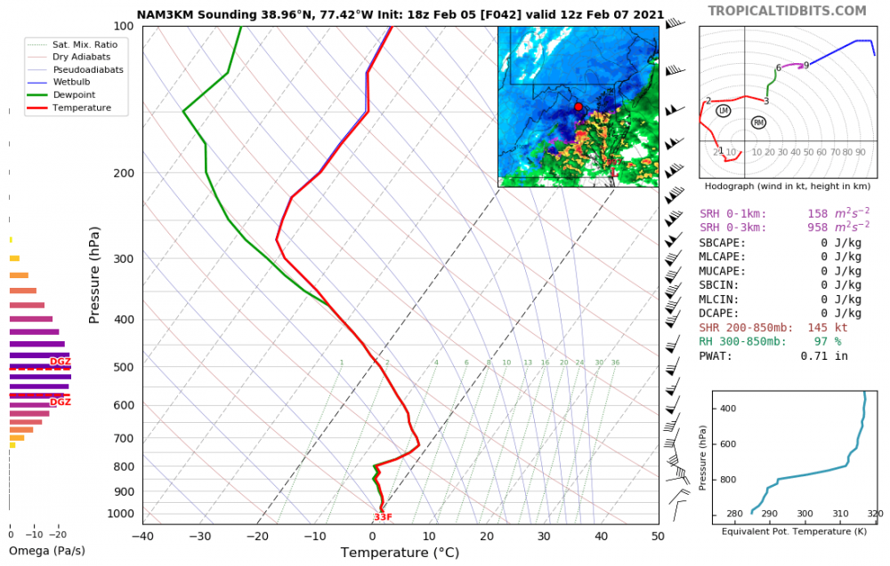
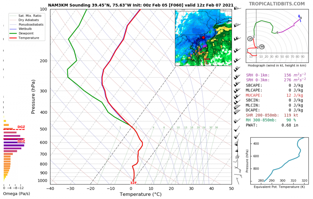
@MillvilleWx @csnavywx @high risk
Now that we are in a break before our next event it's time for Curious George to strike.
Now, as you were discussing back on Friday, this model can overdo convection. But let's pretend that these were real soundings.
What diameter do you believe that aggregates would reach in soundings like these? Also, what would you guess that the snowfall rates would be?
-
Still a great storm. I was getting 2"/hr 1-1.5" diameter italian meatballs at the top of the hour.
-
 1
1
-
-
National Weather Service Baltimore MD/Washington DC
835 AM EST Sun Feb 7 2021

DCZ001-MDZ011-013-014-016-504-506-VAZ052>057-502-071700-
/O.CAN.KLWX.WS.W.0004.000000T0000Z-210207T1700Z/
/O.EXA.KLWX.WW.Y.0008.000000T0000Z-210207T1700Z/
District of Columbia-Southern Baltimore-Prince Georges-
Anne Arundel-Charles-Central and Southeast Montgomery-
Central and Southeast Howard-
Prince William/Manassas/Manassas Park-Fairfax-
Arlington/Falls Church/Alexandria-Stafford-Spotsylvania-
King George-Southern Fauquier-
835 AM EST Sun Feb 7 2021

...WINTER WEATHER ADVISORY IN EFFECT UNTIL NOON EST TODAY...
...WINTER STORM WARNING IS CANCELLED...

* WHAT...Snow. Additional snow accumulations of 1 to 3 inches.

* WHERE...The Washington and Baltimore Metropolitan area as well
  as portions of the Virginia Piedmont.

* WHEN...Until noon EST today.

* IMPACTS...Plan on slippery road conditions.

* ADDITIONAL DETAILS...Visibility will be reduced to around one-
  quarter mile at times through late this morning. Temperatures
  will rise well above freezing this afternoon, but temperatures
  will fall quickly below freezing this evening.
-
-
2 hours ago, H2O said:
that should make it impossible to snow sunday
53F at IAD. February 1987 redux.

-
 1
1
-
-
Rain/Sleet w/ a very mangled flake or three in Herndon, VA.
-
-
1 minute ago, NorthArlington101 said:
Saw a Twitter report of sleet in Wintergreen. Nothing interesting happening in Charlottesville.I actually DID get some ice pellets in Herndon about 15 minutes ago.
5th day in a row with frozen precip.
-
 1
1
-
-
There seems to be a very light band of precip moving through northern VA which, believe it or not, may be hitting the ground in some spots. Is anyone getting anything? Pinging?
-
On 2/1/2021 at 6:51 AM, George BM said:
Dec 7,9,14,25/2020: T
Dec 16-17, 2020: 2.1"
Dec 18, 2020: 0.2"
Jan 5, 2021: T
Jan 18, 2021: T
Jan 20, 2021: 0.1"
Jan 25-26, 2021: 0.2"
Jan 31- Feb 1, 2021: 4.3"
Total as of Feb 1, 2021: 6.9"
Dec 7,9,14,25/2020: T
Dec 16-17, 2020: 2.1"
Dec 18, 2020: 0.2"
Jan 5, 2021: T
Jan 18, 2021: T
Jan 20, 2021: 0.1"
Jan 25-26, 2021: 0.2"
Jan 31- Feb 3, 2021: 5.0"
Total as of Feb 4, 2021: 7.6"


Feb 18/19 Disco/Obs
in Mid Atlantic
Posted
That looks exactly like the sleet/ mangled-flake? I just measured. I measured some ice chunks between 0.25-0.5" across.