

George BM
-
Posts
3,048 -
Joined
-
Last visited
Content Type
Profiles
Blogs
Forums
American Weather
Media Demo
Store
Gallery
Everything posted by George BM
-
What is LFG? It's been said a lot and I'm curious?
-
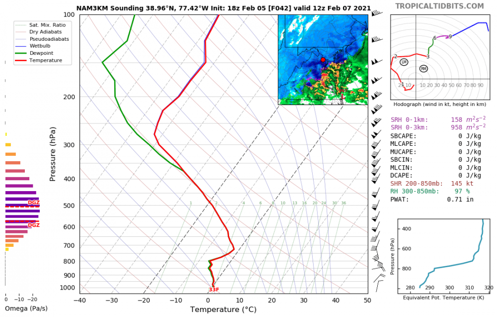
38.966, -77.412
-
Yeap. URGENT - WINTER WEATHER MESSAGE National Weather Service Baltimore MD/Washington DC 843 AM EST Mon Feb 22 2021 MDZ008-011-504-506-508-VAZ052-053-506-222000- /O.EXA.KLWX.WW.Y.0016.000000T0000Z-210222T2000Z/ Cecil-Southern Baltimore-Central and Southeast Montgomery- Central and Southeast Howard-Southeast Harford- Prince William/Manassas/Manassas Park-Fairfax-Eastern Loudoun- 843 AM EST Mon Feb 22 2021 ...WINTER WEATHER ADVISORY IN EFFECT UNTIL 3 PM EST THIS AFTERNOON... * WHAT...Rapid onset of snow which will result in snow covered roadways. Snow accumulations of up to one inch. * WHERE...Portions of central and northern Maryland and northern Virginia. * WHEN...Until 3 PM EST this afternoon. * IMPACTS...Plan on slippery road conditions. The hazardous conditions will impact the morning or evening commute. PRECAUTIONARY/PREPAREDNESS ACTIONS... Slow down and use caution while traveling. When venturing outside, watch your first few steps taken on steps, sidewalks, and driveways, which could be icy and slippery, increasing your risk of a fall and injury.
-
Hmmm... I don't know about that. Instability looks too low for a decent convective severe threat down there. If dews were a bit higher then I'd agree.
-
I wish I'd saved the image someone posted late last year. The difference in how far above average areas east of I-95 and how far below average areas west of I-95 were wrt rainfall was very stark.
-
Whaddup, peeps?!
-
Dec 7,9,14,25/2020: T Dec 16-17, 2020: 2.1" Dec 18, 2020: 0.2" Jan 5, 2021: T Jan 18, 2021: T Jan 20, 2021: 0.1" Jan 25-26, 2021: 0.2" Jan 31- Feb 3, 2021: 5.0" Feb 4-5, 9/ 2021: T Feb 7, 2021: 2.4" Feb 10-11, 2021: 0.4" snow/sleet Feb 13, 2021: 0.2" sleet Feb 18, 2021: 1.0" sleet (some pea-sized sleet for a time around 10am) Total as of Feb 18, 2021: 11.6"
-
...Any potenial H5 patterns standing out to you atm?
-
That looks exactly like the sleet/ mangled-flake? I just measured. I measured some ice chunks between 0.25-0.5" across.
-
Probably pea-sized hail- uhh I mean sleet over the past 10-15 minutes in Herndon w/ some flakes mixing in around 10am.
-
Snow mixing in w/ the sleet now in Herndon. 90/10 sleet/snow.
-
29/12 at IAD.
-
Dec 7,9,14,25/2020: T Dec 16-17, 2020: 2.1" Dec 18, 2020: 0.2" Jan 5, 2021: T Jan 18, 2021: T Jan 20, 2021: 0.1" Jan 25-26, 2021: 0.2" Jan 31- Feb 3, 2021: 5.0" Feb 4-5, 9/ 2021: T Feb 7, 2021: 2.4" Feb 10-11, 2021: 0.4" snow/sleet Feb 13, 2021: 0.2" sleet Total as of Feb 15, 2021: 10.6"
-
Looking at soundings for late tonight - pre-dawn tomorrow, with some elevated instability I wouldn't entirely be surprised if a few heard thunder especially east of I-95.
-
2021 Mid-Atlantic Severe Weather - General Discussion
George BM replied to Kmlwx's topic in Mid Atlantic
Well... looking at soundings for late tonight - pre-dawn tomorrow, with some elevated instability I wouldn't entirely be surprised if a few heard thunder especially east of I-95. #SOON #Aroundthecorner -
https://weather.cod.edu/satrad/nexrad/index.php?parms=LWX-N0Q-1-48-50-usa-rad# https://weather.cod.edu/satrad/?parms=regional-eastcoast-comp_radar-96-1-25-1&checked=map&colorbar=undefined
-
@yoda @Kmlwx Knock yourselves out. https://www.spc.noaa.gov/exper/outbreaks/# See you on the flip side when you're out of the wormhole.
-
IIRC, and don't quote me on this, the guidelines for measuring ice accretion is taking the average of the amount of ice on top of a twig and below the twig. Ex: 0.12" ice accretion on top of the twig and 0.02" of ice visible below the twig gets you 0.07" of ice accretion (0.12 + 0.02)/ 2 I'll double check though.
-
Sleet here. Hopefully it will change back to ZR in due time. 28/23 at IAD.
-
Indeed! I mean Bob Chill has been waiting for his foot of ice. For me an ice storm w/ at least one inch of ice accretion would be nice. Afterwards, hopefully we can score a legit areawide severe event and/or decent tropical event.
-
Dec 7,9,14,25/2020: T Dec 16-17, 2020: 2.1" Dec 18, 2020: 0.2" Jan 5, 2021: T Jan 18, 2021: T Jan 20, 2021: 0.1" Jan 25-26, 2021: 0.2" Jan 31- Feb 3, 2021: 5.0" Feb 4-5, 2021: T Feb 7, 2021: 2.4" Total as of Feb 8, 2021: 10.0"
-
... and even if you do, the boundary was dropping south at the end of the run. You were about to flip to wintery precip.
-
@MillvilleWx @csnavywx @high risk Now that we are in a break before our next event it's time for Curious George to strike. Now, as you were discussing back on Friday, this model can overdo convection. But let's pretend that these were real soundings. What diameter do you believe that aggregates would reach in soundings like these? Also, what would you guess that the snowfall rates would be?
-
Still a great storm. I was getting 2"/hr 1-1.5" diameter italian meatballs at the top of the hour.


