

George BM
-
Posts
3,048 -
Joined
-
Last visited
Content Type
Profiles
Blogs
Forums
American Weather
Media Demo
Store
Gallery
Everything posted by George BM
-
Well known liquor amateur here. Some alcoholic beverages can make you feel warmer?
-
IAD got down to 24F.
-
Got down to 29F at IAD w/ wind chills in the upper teens. It made for a fun morning run...
-
April graupel brings May Cicadas. Also... another month closer.
-
Temperatures shall rise. Humidity shall rise. The sun-angle shall rise. Bugs ... shall rise. ... That's after the coming cold shot, of course.
-
Just came in from my first cut. Nicest day this week for it.
-
43/24 at IAD currently after getting down to 41F. Gusty.
-
Some things just don't change lately. Ex. The near sub-tropical entity dropping 2+ inches of rain with the western edge along- you know the interstate continuing last years theme. As always, persistence until it isn't anymore. But this persistence has been persisting persistently for a while. It's going to change... eventually.
-
2021 Mid-Atlantic Severe Weather - General Discussion
George BM replied to Kmlwx's topic in Mid Atlantic
Yeap. No CG lightning detected anywhere in the region on radarscope. -
2021 Mid-Atlantic Severe Weather - General Discussion
George BM replied to Kmlwx's topic in Mid Atlantic
Yeah. March climo and the tendency for overnight storms to our west to sink south of modeled are really keeping my expectations in check for Sunday atm. -
2021 Mid-Atlantic Severe Weather - General Discussion
George BM replied to Kmlwx's topic in Mid Atlantic
The last time, from my memory anyway, that DC was in a hatched zone was on a Day 3 outlook for April 6, 2017. The last time, from my memory anyway, that DC was in a hatched zone at gametime was on February 24, 2016. -
2021 Mid-Atlantic Severe Weather - General Discussion
George BM replied to Kmlwx's topic in Mid Atlantic
I actually just got Radarscope yesterday for my phone. It's wonderful for tracking severe weather. -
2021 Mid-Atlantic Severe Weather - General Discussion
George BM replied to Kmlwx's topic in Mid Atlantic
Ah, great to see the weather.cod.edu site taking a lunch break now. -
But how about Avocado juice?
-
Okay. Let me try this. @Mrs.J @losetoa6 I hope you had great birthdays last week! @NorthArlington101 @fourseasons Happy Birthday to you both! @Always in Zugzwang @vastateofmind Happy Birthday to you both in advance! Did I miss anyone?
-
Mid-Atlantic winter 2020-21 snowfall contest
George BM replied to AnEndlessMaze's topic in Mid Atlantic
My friend my friend neva gonna happen my friend. -
Three possible years (I don't know for certain. I'm just basing this off of the weather pattern that I remember at those times.) are 2010, 2012 and maybe 2020? Obviously, it also depends on the reporting location.
-
Oh wow. I actually never knew that... nearly 18 years near the airport and you'd think I'd know this. I love learning new things though. 48/46 w/ drizzle at IAD.
-
Yeah. It's all more spread out than before requiring scrolling on mobile (it wasn't like that before). But like you said, they bothered which = it's being used. *Sidenote: Is runway 19 and 01 at Dulles really oriented from 190* to 10*? I always thought it was due north to south. Perhaps just some kind of approximation?
-
2021 Mid-Atlantic Severe Weather - General Discussion
George BM replied to Kmlwx's topic in Mid Atlantic
45% TOR area added now.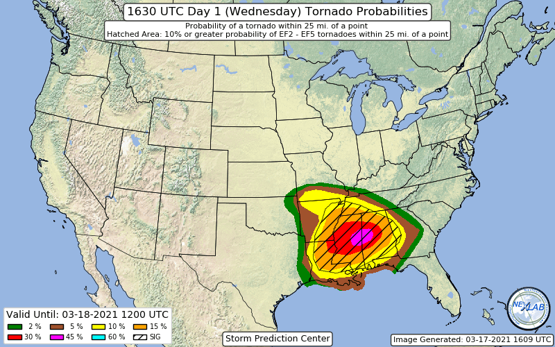
-
Updated http://iadasos.org/IAD/index.html @MN Transplant
-
2021 Mid-Atlantic Severe Weather - General Discussion
George BM replied to Kmlwx's topic in Mid Atlantic
@yoda Ay, where're you at?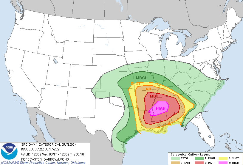
-
2021 Mid-Atlantic Severe Weather - General Discussion
George BM replied to Kmlwx's topic in Mid Atlantic
April of 2019 was better than usual as a whole for these parts. The April 14-15th event could've been something memorable if timing was + or - 12 hours. A lot of moonlit skies between the storms that night once the mid-level dryslot moved overhead. Make that sunshine and add 5-10F then... -
2021 Mid-Atlantic Severe Weather - General Discussion
George BM replied to Kmlwx's topic in Mid Atlantic
With the SLGT getting north of Richmond... though March climatology... Caddy Waddy... I'm low-key watching far southern zones for now, though. -
Very nice. ... So, in other words, the "Saturday Morning" was a similar situation to the Popeyes Chicken sandwich hype from 2019-2020?


