George BM
-
Posts
3,048 -
Joined
-
Last visited
Content Type
Profiles
Blogs
Forums
American Weather
Media Demo
Store
Gallery
Everything posted by George BM
-
National Weather Service Baltimore MD/Washington DC 835 AM EST Sun Feb 7 2021 DCZ001-MDZ011-013-014-016-504-506-VAZ052>057-502-071700- /O.CAN.KLWX.WS.W.0004.000000T0000Z-210207T1700Z/ /O.EXA.KLWX.WW.Y.0008.000000T0000Z-210207T1700Z/ District of Columbia-Southern Baltimore-Prince Georges- Anne Arundel-Charles-Central and Southeast Montgomery- Central and Southeast Howard- Prince William/Manassas/Manassas Park-Fairfax- Arlington/Falls Church/Alexandria-Stafford-Spotsylvania- King George-Southern Fauquier- 835 AM EST Sun Feb 7 2021 ...WINTER WEATHER ADVISORY IN EFFECT UNTIL NOON EST TODAY... ...WINTER STORM WARNING IS CANCELLED... * WHAT...Snow. Additional snow accumulations of 1 to 3 inches. * WHERE...The Washington and Baltimore Metropolitan area as well as portions of the Virginia Piedmont. * WHEN...Until noon EST today. * IMPACTS...Plan on slippery road conditions. * ADDITIONAL DETAILS...Visibility will be reduced to around one- quarter mile at times through late this morning. Temperatures will rise well above freezing this afternoon, but temperatures will fall quickly below freezing this evening.
-
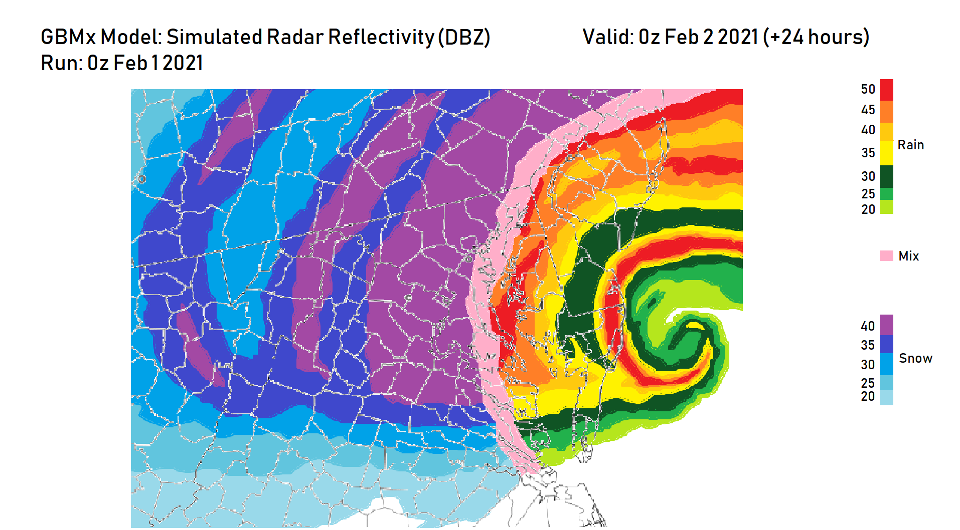
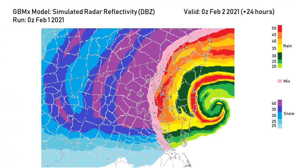
It's likely overdone as others have mentioned in the thread for this event but lol. Softball-sized parachutes?

-
53F at IAD. February 1987 redux.
-
Rain/Sleet w/ a very mangled flake or three in Herndon, VA.
-
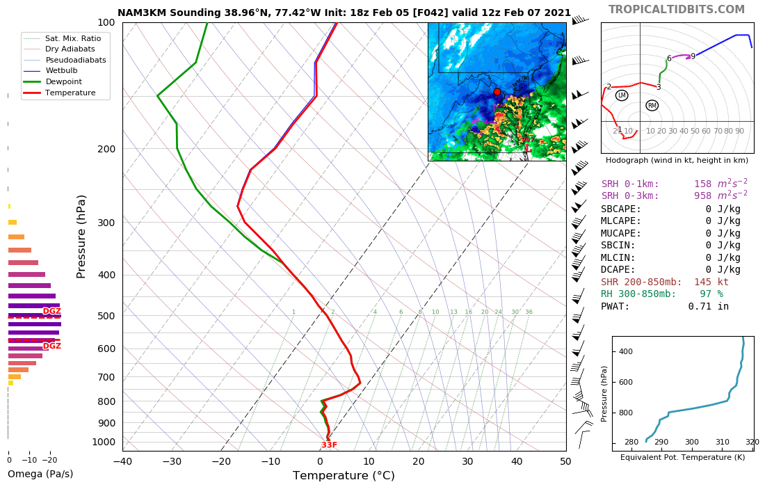
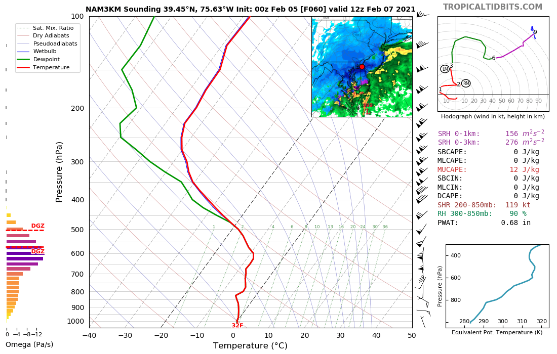
Just for lols but check out the Omega and elevated CAPE combo in this sounding over northern Delware. At the least it shows the potential with this one fronto-wise.

-
I actually DID get some ice pellets in Herndon about 15 minutes ago. 5th day in a row with frozen precip.
-
There seems to be a very light band of precip moving through northern VA which, believe it or not, may be hitting the ground in some spots. Is anyone getting anything? Pinging?
-
Dec 7,9,14,25/2020: T Dec 16-17, 2020: 2.1" Dec 18, 2020: 0.2" Jan 5, 2021: T Jan 18, 2021: T Jan 20, 2021: 0.1" Jan 25-26, 2021: 0.2" Jan 31- Feb 3, 2021: 5.0" Total as of Feb 4, 2021: 7.6"
-
*subsidence*
-
Jan 31st - 33rd Storm Obs and Disco like it's 1979
George BM replied to Bob Chill's topic in Mid Atlantic
DCA has hit 33F so far today. -
Feb Long Range Discussion (Day 3 and beyond) - MERGED
George BM replied to WinterWxLuvr's topic in Mid Atlantic
The image above shows total precip for the past 6 hours. On pivotal it shows instanteous precip rates at a given time. -
Feb Long Range Discussion (Day 3 and beyond) - MERGED
George BM replied to WinterWxLuvr's topic in Mid Atlantic
The day 7 threat has turned into a 6 day threat one day later... -
Jan 31st - 33rd Storm Obs and Disco like it's 1979
George BM replied to Bob Chill's topic in Mid Atlantic
What part of Herndon are you in? Just curious as I haven't seen a flake just yet this morning. Precip showers are spotty atm. -
You still have time to haul it NNE before it's too late and conditions get too treacherous. Get going now. We need to see pictures of you standing in your street in front of your house surrounded by complete and blinding whiteness pretending that you have been reaped and gone to snow paradise. Tick tock tick tock.
-
Dec 7,9,14,25/2020: T Dec 16-17, 2020: 2.1" Dec 18, 2020: 0.2" Jan 5, 2021: T Jan 18, 2021: T Jan 20, 2021: 0.1" Jan 25-26, 2021: 0.2" Jan 31- Feb 1, 2021: 4.3" Total as of Feb 1, 2021: 6.9"
-
-
Don't mind me. Just dropping this off for later (post-storm).
-
Jan 31st - 33rd Storm Obs and Disco like it's 1979
George BM replied to Bob Chill's topic in Mid Atlantic
7am: 1.1" 8am: 1.7" 9am: 2.1" 10am: 2.4" 11am: 2.6" Herndon, VA. -
Jan 31st - 33rd Storm Obs and Disco like it's 1979
George BM replied to Bob Chill's topic in Mid Atlantic
THIS! He thinks he has it bad with 2 feet. I'm right by Dulles and somehow only have 2.4" as of 10am w/ flurries. Perhaps extreme substance right by the epic snow-band? -
Lol I heard that this afternoon. It definitely sounded like she said 48 inches rather than 4 to 8. So if a few people are going crazy panic buying food/toiletries and spreading rumors about 4 feet of snow we know why.
-
Yes that one. Around January 17th IIRC.
-
@psuhoffman A very random question for you. How bad was the ice event down here in Herndon, VA in 1994 when you were in the area? Was there a good bit of damage?
-
We always welcome new members here. To answer your question... : A ccb looks like to set up somewhere. The intensity of it and its exact location are yet to be determined, of course, depending on the exact track of the mid-level low and whether the 500mb low can remain closed (source more knowledgeable posters than me). But if I were a betting man I would guess that you would most likely end up with MECS-level accumulations w/ an upside of a borderline MECS/HECS at your location. There are far more knowledgeable posters than me here like @CAPE @psuhoffman @WxUSAF @MillvilleWx @high risk and many more people as you will soon find out. We are a crazy bunch that will fight to the death sometimes for the snow-max zone. But we aren't as crazy as we seem online in person.
-
You don't like the rush of wind and snowflakes hitting your face?
-
I remember talk about jebwalking music during the January 2019 event. So probably around there somewhere.