SENC
-
Posts
910 -
Joined
-
Last visited
Content Type
Profiles
Blogs
Forums
American Weather
Media Demo
Store
Gallery
Everything posted by SENC
-
I (think) the Modeling (Models), haven't taken this lil tid-bit of Data into account.. (Just My 2 pennies here).. .. As the Low transfers off the Coast, The SST's here, are in fact, WARMER than usual, than other years.. by 10F .. Temps are still reading 62~65F here on the Beach's..
-
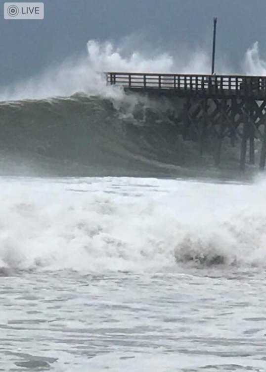
Great PHB Folks.. From KILM here on the Coast.. High pressure nosing in from the northeast on Saturday while a potent trough dives south into the Ark-La-Tex. The wedge will keep highs stuck in the low to mid 40s north of I-95 while southern areas see upper 40s. Saturday night as the upper low crosses the Gulf States its initial surface low will be directly underneath the upper low. At the same time height falls and strengthening warm advection cause falling pressure off the Southeast coast and POPs will be rising. The 00Z guidance suite is showing some semblance of coming towards a solution, but at this time it seems that none of them probably have the evolution of the low level features correct. The GFS probably looks the most suspect in its (new) depiction of a dual- centered low though it has some faint support from the Canadian. The EC solution indicates that the coastal low immediately comes to dominate especially by 12Z Sunday. The aforementioned congealing of just about all guidance is for a slightly slower progression as well as a storm track closer to the coast. For our CWA this means that the opportunity for wintry precip has decreased. At this time it looks like what may start as light rain early on will then change to a chance for wintry precip as the wetbulb process causes temperatures to fall, especially inland. The closer track suggests that this window may be small before the warm air aloft overwhelms the system and most of the event is a cold rain, and possibly a substantial drought-relieving one at that. It is worth stressing however that this is only one model run and there still appears to be an increasing chance for a significant ice storm SOMEWHERE in the Carolinas.
-
Lovin it..On the Coast!Current Temps 63FPressure 29.91 inVisibility 8 milesClouds Partly CloudyDew Point 60 FHumidity 90 %
-
No you don't trust me..
-
What a NICE DAY on the Beaches.. High79º Low69º Humidity71%inch Dew Point65.8ºinch Rainfall 0.02 inch Pressure29.82 inch Winds.. NNE @ 11mph
-
AF Recon Teal73 almost on the scene..
-
NOAA43 departed Lakeland, now just leaving Fl. coastline
-
Ya got that right..
-
I thought it would be someone elses fault? isn't that how it ends? Asking for a friend.. Wishcasting a Cat 5 on Top on #NOLA,, complete Leeve Failures,, I jest..
-
[quote]Ok, so my post responding to the crazy person ranting about climate change and the left was deleted, but that stays up. Nice storm mode.[/quote] I rather enjoyed His *RANT* coming from a retired COE,, It's called "Truth telling" & He's probably right..
-
Not unless it's snake bites, gator attacks, Bull sharks , We just deal with it..
-
Need to come to SENC after a cane... Ya'll are WEAK.. 2 weeks the NORM.. Country folks can survive & all that..
-
I believe it's that New alien, Common Core Maff I've been hearing about? Anyhoo BOT.. Interesting Analyses, We here in SENC up too OBX Coast(s) have had, about our wettest Summer eva, and Lotsa QPF could be our demise,, Dennis/Floyd esq, type stuff,, In other words extreme flooding very possible.. If some of those Forecast tracks, come to pass..
-
Can You pass My way, What your Smoking?
-
Best bait too use catching trout.. It's going to be My first try this weekend.. (Gatlinburg,tenn areas)..
-
Current Obs, just alil warm out..
-
Roughly 2.0" of precip here in the ILM FA.. SENC/carolinas region.. 74/85.. light rain currently drought canceled..
-
Most *Notable*, (In My book).. Report post Posted Sunday at 02:34 AM Hi! I’m so sorry to hear that he and his family endured such a horrible loss. I was born thirty years (1970) after your neighbor, in Wilmington, and have been a hurricane researcher from the time I experienced my very first hurricane eyewall in 1984 (Diana). Here’s a list of all known TS’ and H’s that have made a direct hit on Wilmington, NC (1940-2020): Dennis (1981) TS Storm 2 (1982) STS (offshore) Diana (1984) Cat 2 (eyewall) Gloria (1985) TS winds (H-offshore) Kate (1985) TS Hugo (1989) TS winds (H-SC landfall) Gordon (1994) TS winds (H-offshore) Opal (1995) TS winds (TS-west) Bertha (1996) Cat 2 (eye).. (I rode that one out on **Sheep Island** on the Lockwood Folly River..) Fran (1996) Cat 3 (eye) (I got "smart" & bought a generator).. Bonnie (1998) Cat 2 (eye) Floyd (1999) Cat 2 (eye) Charley (2004) Cat 1 (eye) Ophelia (2005) Cat 1 (eyewall) Ernesto (2006) TS/Cat 1 (eye) Matthew (2016) Cat 1 (eyewall) Florence (2018) Cat 1 (eye) Isaias (2020) Cat 1 (eye)
-
Yes I've resided in Wilmington, since (forever),, anything after 1969.. My earliest memories, dob in the early 60's..
-
56/48 Light rain.. here on the beach's wonderful! BTW NO GAS down here!
-
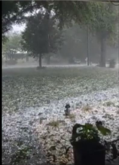
Pics & video.. (LINK).. Hail falls across several counties in the Cape Fear Region (wect.com)
-
Rain/Hail & Thunder.. My Mater plants/ beans got the Smack down today, May no survive Round #2.. (currently).. Not very often you experience HAIL here, Pea & ping pong sized, on/in SENC on the beaches.. At least the Pollen has been "cleaned" somewhat..
-
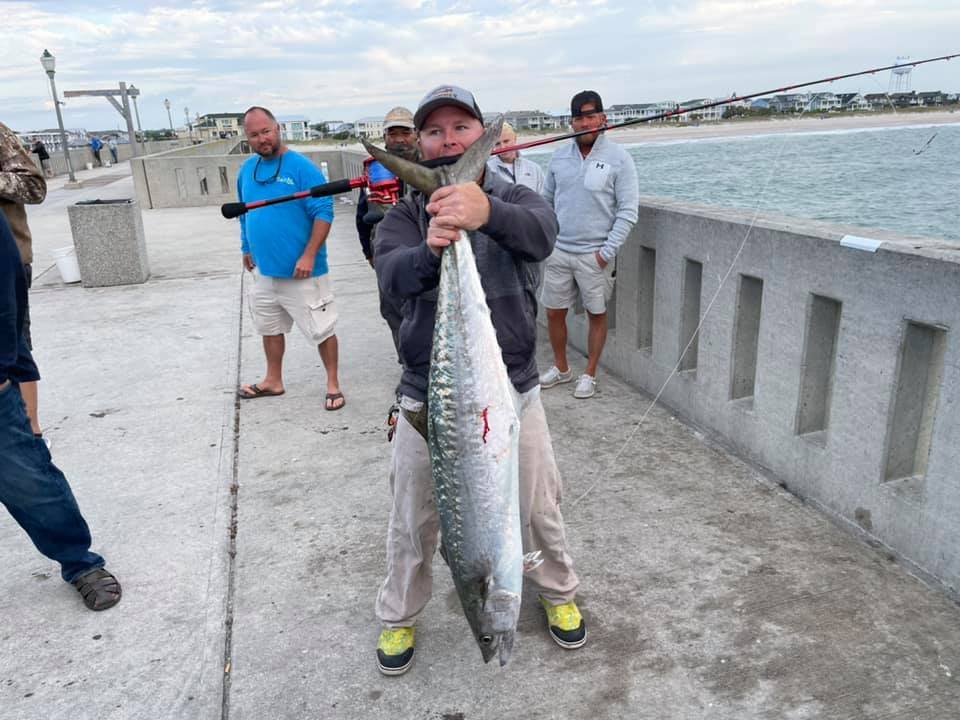
Second Round of Rain/Thunder/Lighting & Hail, today.. I assume things broke the "Cap" quickly after this mornings storms.. Currently 63f Pressure 29.85 in Visibility 7 miles T~storm / lighting thunder & hail.. (again).. Special Marine Warning Issued Dew Point 51 F Humidity 61 % for the sportsmen here the First King was decked on Johnny Mercers pier.. this morning A 40 pound brute..
-
65/48 Thunder/lighting Rain & Hail..
-
49/74 here in Surf City.. Currently 69F Pressure 29.81 in Visibility 10 miles Clouds Partly Cloudy Dew Point 59 F Humidity 74 % Need alil rain to beat back the pollen..