eduggs
-
Posts
5,951 -
Joined
-
Last visited
Content Type
Profiles
Blogs
Forums
American Weather
Media Demo
Store
Gallery
Everything posted by eduggs
-
After many many years of model watching and weather tracking, I have not come across anyone who can interpret clues in LR modeling that can reliably predict snow events. Maybe I would grant that occasionally people are able to anticipate colder/warmer or wetter/drier than normal periods. And in the most simple sense, wetter+colder would give you a better than normal chance for snow. But for the most part I think there are a lot of correlation-causation fallacies at work, perception bias, and a whole lot of other wishful thinking and delusion. It reminds me of stock traders who are convinced they can use their algorithms to pick winners when study after study shows that they perform not better than monkeys.
-
The 0z CMC looks like it moved further away from the GFS for next week. It doesn't have precipitation in the southeast early next week and shows a fairly zonal flow. Edited to add that it fortunately still has a significant event just delayed.
-
Yes I did read what you wrote. Every word. Each synoptic setup or configuration of weather features is unique. But we are simple creates that like to lump things into simple boxes so we can interpret them based on black and white causal relationships. Sure we might be able to broadly anticipate regions of high latitude ridging and troughing 10+ days out... what we simplistically refer to as a "pattern." But that leaves a ton of uncertainty regarding the chance for snow in our backyards. That is why I responded by talking about the LR prediction of snow vs. "pattern" because snow is what we're actually talking about.
-
I disagree that you can recognize a snow producing event 10+ days out with any reliability. This is not northern Honshu Japan. You can approximate longwave trofs and ridges and associated airmasses useful at the regional-scale. But local snowfall is typically driven by smaller scale features that are not accurately resolvable, even with ensemble modeling, at that distant time range.
-
That's my feeling as well. But I keep reminding myself that it's also possible for some or all of the next 4 modeled events to work out positively for snow. And most of the time over the past few winters we had nothing to track. So we should embrace the excitement for this period I think.
-
The wet bulb temp got above freezing today leading to melting even in shaded areas. At 37F it's more likely the wet bulb would have remained sub freezing, which would have limited melting.
-
The 18z NAM says a snowy day (WWA-worthy) is incoming on Wednesday for Harrisburg to Phily to Atlantic City. No snow for most of NYC metro until Wed night and only relatively minor non-sleet accumulations. This "snow streak" doesn't have a ton of support and is likely overdone but an interesting feature to track nonetheless.
-
Warm day today with 50s popping up in a few spots. Feels nice in the sun.
-
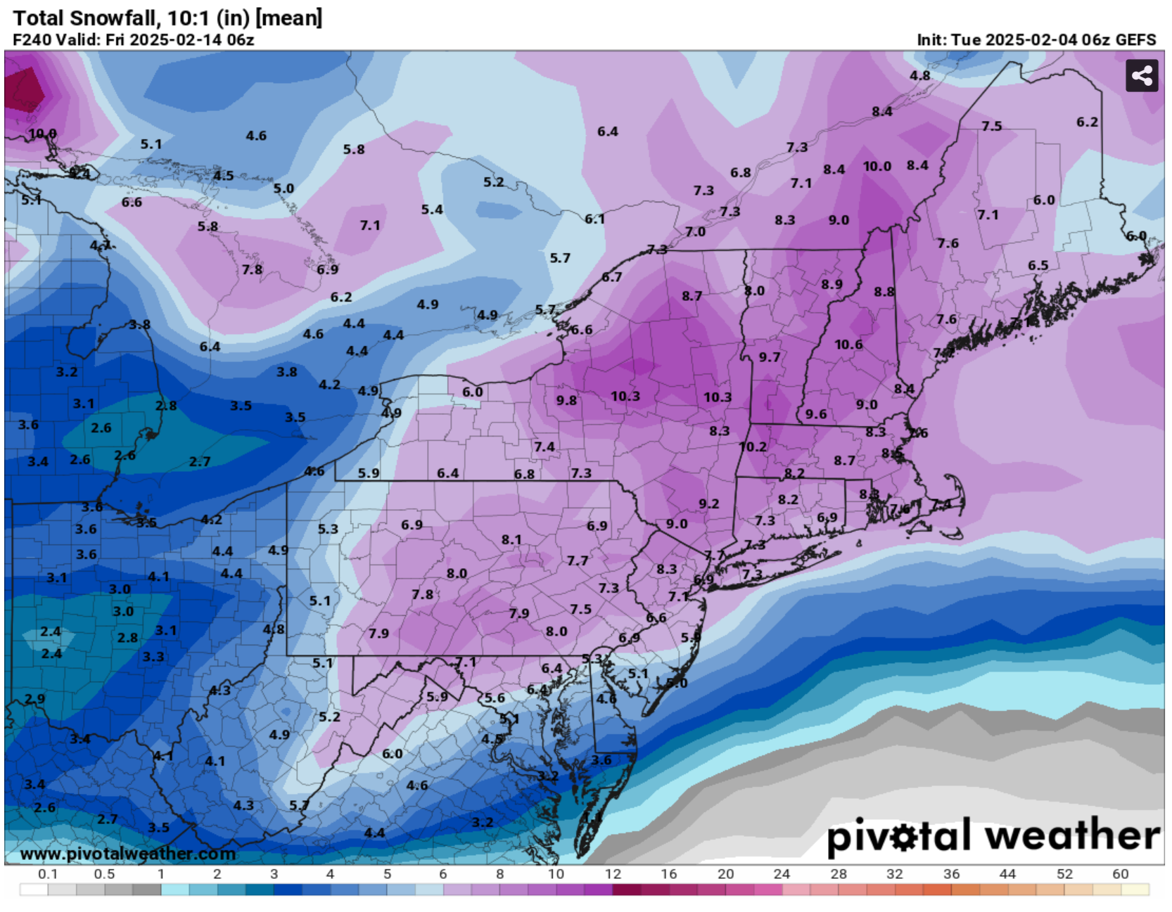
We'll take it. It's a good mean and we have lots of threats to track. But I would prefer the threats be temporally reversed with the bigger ceiling snow threat (12th) moved to the shorter range and the lower ceiling threat (6th) pushed further out. As is, we have less time for/chance of the minor events trending snowier and more chance of the currently modeled snowier threat trending less snowy. In other words, regression to the long-term mean. The sequence of "snow" events could easily end up minor/minor/miss or minor/minor/minor with a total accumulation of something like 4-8 inches. I think that would be a great result in the midst of a snow drought, but whether that would provide a sufficiently snowy appeal might depend on exactly how the snow to mix to rain progresses.
-
Maybe not in Manhattan. But there were two icing events in the past week just outside of the concrete jungle. The upcoming "pattern" produces overrunning waves. That means mid-level warm layers and a ZR risk. The southwest mid-level flow and lack of strong SLP just make it harder to get heavy precipitation and a snow-supporting column together at the same time for more than a few hours.
-
Yes so we have 2 obvious failure modes. Hence the caution w/respect to snow prospects.
-
Maybe you are confusing me with someone else. For snow event tracking, I generally ignore anything past day 10. And I heavily caveat anything past day 7. I also prefer to look at a mid- and upper levels (esp 500mb) instead of surface charts. Based on this I've thought for several days that we have a higher than usual threat of IP and ZR events. I'm possibly less optimistic than some on here for snow over the next 14 days primarily because I don't love the orientation and evolution of the jet stream(s). What I do like a lot is the moisture feed, particularly on the GFS/GEFS that allows multiple weak SLP to generate moderate to signifant precipitation in multiple waves. But most of the good stuff is in the long range where ensemble spread is high and not all mid-range modeling is in agreement... so my excitement for snow is kept in check.
-
Sure, anything is possible. But since not-snow is more likely than snow and this is still in the long range, I think it's reasonable to hedge against a snowier outcome for now. The next 14 days are far from a slam dunk. I think some snow is very likely, but I'm not sold on anything significant for the metro.
-
The constant theme on here is to overhype bigger, LR threats and underhype smaller, short range threats. (Walt and others are distinct counter examples). We should probably try to consider the expected value (in snowfall) of a potential future threat. That takes into account likelihood and magnitude. Obviously something modeled at day 9 is much less likely to produce than day 3. Last night was the 2nd biggest snowfall I've observed locally this winter (missed the Jan snow). It was also the hairiest driving I've experienced this winter. Last night's snow walk with the parachute bombs to end it and no change to rain or mix was full-on winter mode for me. Let's take to the bank what's right in front of us cause we can't count on anything past day 5.
-
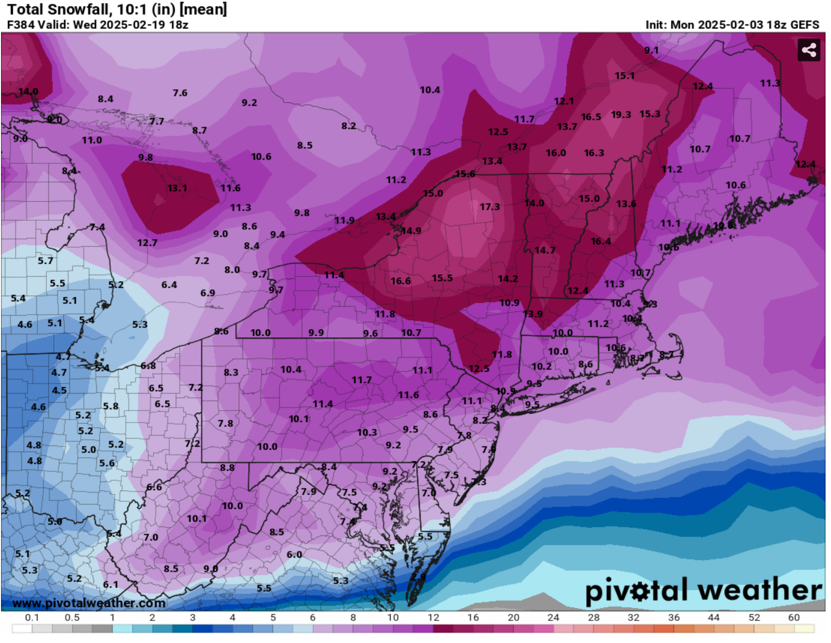
Still very large spread with respect to timing and intensity of precipitation/features at that time frame. Let's get it to day 5 looking like this with less spread...
-
The difference is visible on the 500mb (h5) charts. Sorry for not posting the picture, but it's easy enough to check. The 0z/12z CMC squash the wave/sequence of waves around day 10. The GFS has a moist flow from the southwest at h5.
-
The GFS is very wet over a 2+ week period. But the CMC is not on the wave train. ECM mostly supports the GFS.
-
Trof axis from MT to Baja is a little unnerving. But really good moisture feed. Multiple wave threat.
-
For reference, the ICON has for days shown the "snow streak" that Walt mentioned during the day on Wed. 6z NAM too. Most other guidance is/was less pronounced, so it would be easy to not know what he's talking about. This feature might turn out to be virga or disappear altogether.
-
Too bad the Wednesday "snow streak" has shifted south of our region in recent days. It would/could have led to a sneakily snowy day without the immediate threat of a change to ice. Since it's kind of a subtle feature I guess there's a chance modeling will bring it back.
-
God I hope so. It's been a long time since we had a good stretch of events backing events. For me personally it's been even longer due to moving around. The next 2 snow threats locally both look to have a pronounced warm layer aloft. I'm dubious of big snow locally (though it's possible with big QPF at the onlet). These are wintry threats for sure but possibly only light snow accumulations. The big modeled snow is out at day 9 and beyond. I'm hopeful about this period but I just can't get too excited. Too much can go wrong at that range.
-
This evening was really nice for a few hours. CT esp looked solid on radar. But I think the mixing in ZR and elevated warm layer despite a cold surface is a sign of things to come. There looks to be several chances for snow coming up. Maybe we get lucky with a well timed front end thump. But out to 8 or 9 days or so it looks like mixed events at best. People like Walt forecast for the hazards. This evening, the driving was certainly very hazardous despite minor snow accumulations. But most of us are looking for more significant snow to enjoy outdoors. I'm excited for tracking but not yet optimistic for the goods.
-
Snow can accumulate in any month provided the temperature is supportive. Snow can certainly accumulate in the spring. My original post mentioned that in recent years, late Feb has been very spring-like, which is true. The reason why I prefer mid-winter snow to spring snow is because it makes outdoor snow-related activities more enjoyable. Melting snow and mud is less enjoyable for skiing, snow shoeing, ski touring, sledding, and walks in the snow.