

larrye
-
Posts
254 -
Joined
-
Last visited
About larrye

-
Extreme Cold, Snow & Sleet: SECS 1/24 - 1/26
larrye replied to TriPol's topic in New York City Metro
That may be true, but who knows where the planes will be and what flights will be cancelled at that point? -
At some point, there will be an "official forecast" of accumulations. While I agree with you in terms of trying to "microanalyze" what they are going to be, I assume you're not trying to say that we have no clue at this point? It would appear to be a light/minor event (at least at this point) with likely accumulations perhaps 1"-3" for the general area? Am I wrong?
-
Two Mdt to high impact events NYC subforum; wknd Jan 6-7 Incl OBS, and mid week Jan 9-10 (incl OBS). Total water equiv by 00z/11 general 2", possibly 6" includes snow-ice mainly interior. RVR flood potential increases Jan 10 and beyond. Damaging wind.
larrye replied to wdrag's topic in New York City Metro
I don't see where anyone has said anything with 100% certainty. But you also have to be realistic based on the data that has been made available, with the trends, with climatology, and with previous history with snow events and their likely modeling trend progression. Things can change, and they probably will. People are commenting based on data 4 days out.- 3,610 replies
-
- 2
-

-
- snow
- heavy rain
- (and 5 more)
-
Worth mentioning when it's day 12 and the GFS appears consistent over many runs at the very least showing an EC threat. Not saying that long-range is reliable or you can draw any conclusions. Not saying it won't disappear completely tomorrow. Just sayin' it's something to watch over the next week (just as we did for Lee at that point).
-
Probably a slower hurricane that just isn't getting caught up in the trough, or possibly a stronger influence from Margo?
-
That's not what I recall seeing on the Euro. There were some runs a few days back where it was a hit for the Cape, but in the last few days, it's pretty much been a hit for NS (albeit usually further west than the GFS). I think it's been more consistent than you think over the past couple of days.
-
Do we still have an Omega block pattern in place and if so, any indications on the long-term models as to when we can expect a change?
-
I think they consider "White Plains" to be HPN, which is actually about 5 or so miles north of White plains.
-
It certainly consistently overstates QPF.
-
Preface by saying I'm not a met. But I DO know that the NAM usually overstates QPF and must always be taken with a grain of salt. The fact that there is some validation from the ECMWF makes me raise an eyebrow, though. But I wouldn't get too excited based strictly on the NAM.
-
I was wondering if anyone would notice this.
-
Anybody care to comment on the 00z GFS solution for Ian? Seems to drive the remnant low inland over the NC/VA area. Then it appears to spurn a secondary low off the coast on Sunday, and then either another one on Tuesday or it's actual the remnant low that strengthens off the coast? 00z Euro seems to do something similar.
- 1,529 replies
-
- 1
-
-
- hurricane
- tropical storm
- (and 1 more)
-
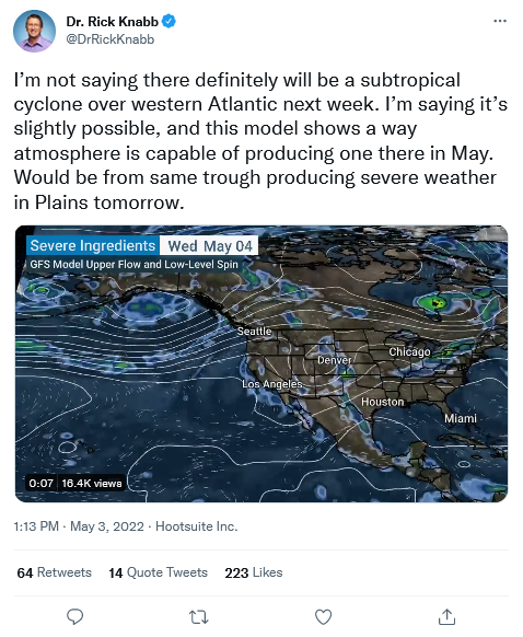
Some chatter out there about a possible tropical low developing in the Atlantic next week: https://twitter.com/DrRickKnabb/status/1521538363106471941?s=20&t=RA2iZe897rOAe7xSAJpJqQ
-
"Be careful with clown maps" here is like saying don't do drugs to an addict.
-
2/13 Light/Moderate Snowfall Nowcasting & Observations
larrye replied to Northof78's topic in New York City Metro
Final outcome of WHAT storm? There never really was any model that with any consistency indicated anything beyond a few inches for the NY metro. There was never any solution that truly bombed out near or right inside the benchmark. At least for the storm last week, there were some consistent indications at this point (72 hours ahead of time) even though there were variations in the solutions. Look, technically, you're right. There's always a chance. You never know. But you never know if the Yankees are going to win a ballgame on any given day either.

