hlcater
-
Posts
2,686 -
Joined
-
Last visited
Content Type
Profiles
Blogs
Forums
American Weather
Media Demo
Store
Gallery
Everything posted by hlcater
-
I’m pretty bullish on this one relatively speaking so went ahead and made a thread.
-
About time for this one. Models are already fairly robust with 92L with the majority reaching hurricane strength and a good chunk with major status. Environment through D4 is just about as good as it gets, so the intensity ceiling is probably quite high on this one relatively speaking. Cool water, shear and dry air should ensure weakening by landfall at least.
-
92L looks mildly interesting in the medium term. Should have a nice anticyclone/outflow pattern... in the W carib in October.
-
Probably gonna be a big winter for tornadoes and severe weather across the SE.
-
lives were SAVED on 3/28
-
the 2020 severe season started and ended in 45 minutes. 4/7 was okay locally, and 5/23 was fair. But the census for this season yields 2 mediocre severe events, and one exceptional one. I'd honestly trade the derecho for more/better tornado days than we had this year.
-
zzzzzzzzzzzzzzzzzzzzzzzzzzzzzzzzzzzzzzzzzzzzzzzzzzzzzzzzzzzzzzzzzzzzzz
-
some mad girth on that one
-
Sure. When there was no radar you’d 100% miss that radar signature
-
if nothing else, they've got it named now and can lengthen the path in post if necessary.
-
lol
-
What a storm.
-
Imagine wasting hodographs like these because 700mb temps are 2 degrees too warm.
-
I wish it was. At least then we wouldn’t be having this discussion.
-
DOA
-
The thermal ridge at 700mb is going to be too strong. It will initate, but after dark and along the CF.
-
The T/Td intersection below the EML is cloud cover, and one of the reasons why I’m not at all confident in initiation. That and the stout EML above it are extremely problematic. Regarding the hodograph, veered flow probably isn’t an issue here as the flow aloft is NWly and the resulting hodograph is quite tasty imo. I don’t have many concerns about the parameter space not being able to support a severe/tornado threat. For me, it’s more of what is the chance we get a robust updraft?
-
Some models either do initiate or become extremely close to initiating a storm in this environment. E IA/N IL. I still don’t like EML strength(14c 700s) and subsidence in IA. But far E IA and IL might have a chance....

-
Michael is my ideal hurricane. Fast moving, landfall at 90 degrees, in an area thats not too populated, in the middle of the day, clear eye/intensifying into landfall, in the US, the list goes on.
-
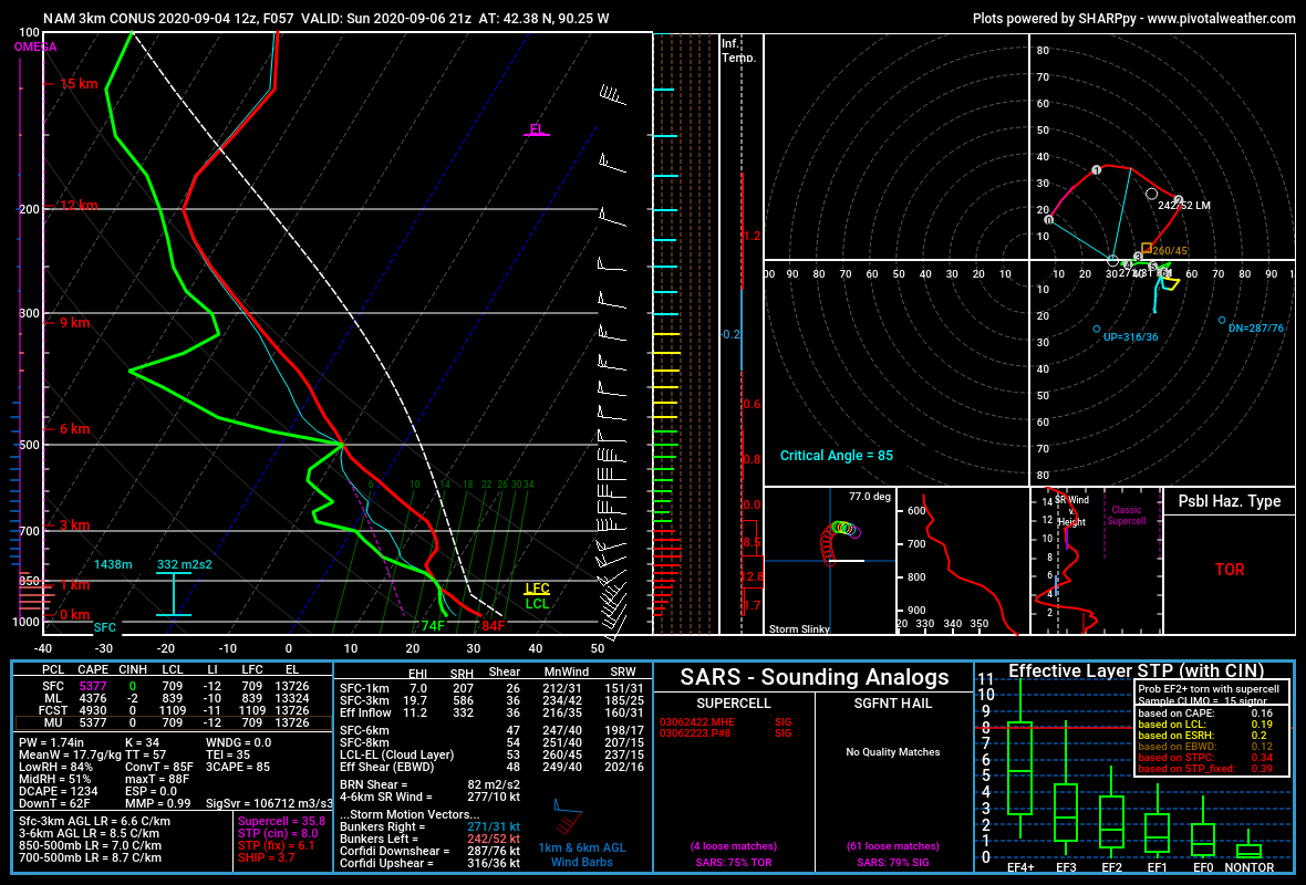
Most models look like that sunday in Iowa. Huge deal if they somehow end up uncapped, but with a reservoir of 14c 700s to the west AND westerly 700mb flow, that's probably not happening.
-
-
Some models do Saturday further west, and some more also have a setup on Monday. Saturday may end up capped due to the lack of a well developed wave. Monday might not exist at all, though the 00z Euro and 12z GFS do each have setups on Monday, even though they are vastly different.
-
always has been
-
hi
-
There's an excellent dataset on wunderground, except it doesn't appear as if any of the PWSs in Benton/Linn actually have data stored for 8/10, go figure.