hlcater
-
Posts
2,686 -
Joined
-
Last visited
Content Type
Profiles
Blogs
Forums
American Weather
Media Demo
Store
Gallery
Everything posted by hlcater
-
some rather glaring organizational problems here. 1) The convective bursts at present have been rather singular (as in singular updraft), asymmetric and transient. 2) These bursts are having a hard time really consolidating over the center probably because they're having trouble persisting. 3) The RMW is very broad and there isn't an inner core structure at all, despite the rather intense convective burst ongoing. 4) The large area of 50kt winds on the northern side likely indicates this storm will have trouble building an inner core in short order, at least having a hard time doing it prior to yucatan landfall. As is, I don't really see this intensifying very quickly with rather significant organizational flaws working against it. I think this makes landfall as a weak cane as it stands now. It may be a strong TS now, but it is still *very* disorganized relatively speaking. Not all 70mph TSs are created equal.
-
Not rapidly organizing, but on the visible loop, you can see the center consolidating a little closer to the big convective blob. Earlier today it was poorly defined and was elongated to the NW Over the past several hours, it has lost quite a bit of that elongation as pressures fall closer to the blob as evident on recon. Lots of work to do yet with it being decoupled and slightly sheared, but organization continues. in other news are there any Actually Good™ gif uploading websites? Levi's site turns out gifs that are like 25mb which greatly limits what you can do with them.
-
Yup that’s what I’m thinking. Would need a storm to separate itself to do much of anything and I just don’t think that happens
-
Conditional setup tomorrow for eastern Iowa that should deliver a nice QLCS with some locally gusty winds at a minimum. Shear is quite good and more than sufficient for a supercell/tornado threat by itself however shear vectors relative to the boundary, degree of forcing on said boundary and risk for cloud cover or a near surface inversion all suggest that risk is low if existent at all, despite the shear/instability that should be present. That said, if additional clearing is realized, there could be a brief window for something if there is a discrete storm around to tap into the 250+ 0-1km SRH/300+ 0-3km SRH. I don’t think this setup has what it takes personally but I probably still get suckered into chasing it due to the 0 minute drive to the target area. Plan would be to just find the warm front and just hope for the best
-
Very photogenic little system. One of my favorites this year for sure.
-
Very interesting to see what recon finds given satellite has only improved from earlier

-
I’ll keep my eye out. thanks for the heads up
-
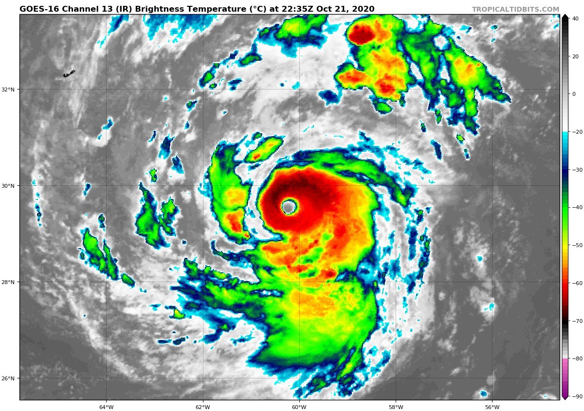
My guess is that the NHC is probably underestimating the intensity currently. Satellite presentation and rather robust circulation suggest true intensity may be more like 80 to possibly 90kts. These rather warm topped/low tropopause storms seem to be prone to being underestimated in intensity like Lee and Ophelia 2017.
-
You're gonna get 6" out of this easy based on radar trends.
-
Thunder. Lol. This is honestly one of the better surprise snow events I can remember. I've got an inch in the grass over the past 30 min or so.
-
This is real high quality stuff right here. Similar(or slightly less impressive) rates in Iowa City.
-
I dropped from 38 at 10am to 30 now on a handheld kestrel.
-
The 6" report in Des Moines is at the Johnston NWS office. Cant really get a more reliable report than that.
-
Yea it just started snowing a few minutes ago in IC and now its coming down pretty hard, perhaps even approaching 1"/hr. Seeing the returns and reports in central Iowa, should see advisory criteria snow here and an extension of the SQW east is probably necessary. Heavy rates should keep surfaces temps AOB 32.
-
Something something quantity over quality that said, the derecho is 1000% a worthy opponent. Damage around here wasn’t quite cat 4 level like some media outlets would like to claim but more equivalent to a 90-100kt storm perhaps; in an area that does not have resilience for those kinds of winds
-
Temp 32 and snow. Nice...
-
Well that was inevitable
-
Dont know where to put this so it goes here. Papin is now an NHC forecaster. Good for him
-
I remember when people, including myself, thought this was gonna rip a hole in space-time in the W Carib. Fun times.
-
I dont like that
-
Probably at peak intensity now or close to it. Favorable shear window is closing and shear begins to increase again by early morning and should induce weakening by mid day or early afternoon at the latest. A fairly large cat 3 peak offshore should be sufficient for another respectable (9-11ft+) surge along the SW LA coastline. Pretty incredible to think areas that saw 15+ ft of inundation last time around could see 10+ ft not a few weeks later. Think that would probably drive me out of SW LA or into the bottle personally.
-
Delta honestly looks great right now, likely as of a result of the last minimization of shear(~15kts down to ~10kts) prior to landfall due to the turn more northward over the past several hours. Has through tomorrow morning to continue intensifying. In the near term, if current convective intensity persists and continues to expand like it has been this evening, a sneaky return to cat 4 would not surprise me before weakening starts to ensue tomorrow morning afternoon landfall.
-
the 119kt measurement was at flight level. SFMRs are being funny at the surface, with a 39kt reading right where you'd expect vmax to be. Not entirely sure they're reliable, but who knows. Standard reduction and pressure falls lend themselves to an upgrade to 100kt C3.
-
those are flight level winds.
-
Regardless of all that, this is probably knocking on the door of cat 3 intensity again.