

ma blizzard
-
Posts
3,059 -
Joined
-
Last visited
Content Type
Profiles
Blogs
Forums
American Weather
Media Demo
Store
Gallery
Everything posted by ma blizzard
-
good points! lazy analysis on my part (BD) was just taking a quick look. if we keep that look for Saturday tho, prob in contention for all time May records Looks like 97 (5/26/1880) is the number to beat at KBOS
-
backdoor Sunday but Saturday MU 90s easy
-
EURO going crazy with the heat next weekend lets goooo
-
could be a good omen for tmrw? def think we over-perform with temps
-
models for sure were too aggressive with the low clouds / low lvl moisture today, especially NW of BOS - PVD .. NAM was garbage
-
that weather is reserved for xmas eve actually
-
trash weather for just about anything other than running
-
we hope it works out! verbatim looks like D10 would be the first 90+ day of the year
-
bicycle day?
-
98 on 4/19 at KPVD? crazy
-
verbatim it isn’t much , but close to something interesting having said that, Euro is on its own here
-
I agree - EURO is on its own with the D6/D7 thing .. a bias we've seen time and time again for sure I'm more interested with what happens next .. solid signal for a coastal ~D9/10
-
long range EURO looks lovely NNE / mountains prob not done yet
-
https://www.nytimes.com/1926/06/18/archives/frost-hits-new-england-farm-and-garden-crops-blighted-by.html
-
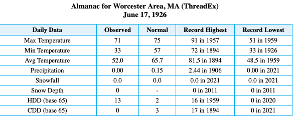
^ got me looking at some of the first / last dates on the BOX climate page .. how about this for latest 33 on record: Must have been quite the airmass to radiate like that 4 days before the solstice
-
-
Saturday, March 19, 2022 Elevated Convection w/Severe Potential
ma blizzard replied to weatherwiz's topic in New England
12/30/2019 https://www.washingtonpost.com/weather/2019/12/30/only-new-england-an-ice-storm-hail-storm-severe-thunderstorm-all-once/ -
not concerned we see 3rd year la niña?
-
March 2022 Obs/Disc: In Like a Lamb, Out Like a Butterfly
ma blizzard replied to 40/70 Benchmark's topic in New England
no problem tossing Thursday if it means Friday is 70-75 and sunny -
fortran?!?
-
incoming squalls in SE NH look solid
-
big gradient with cold lurking .. could be fun!
-
so true! funny how that changes as we get older
-
0z HRRR looks quite amped
-
enjoy! light snow here

