ma blizzard
-
Posts
3,033 -
Joined
-
Last visited
Content Type
Profiles
Blogs
Forums
American Weather
Media Demo
Store
Gallery
Everything posted by ma blizzard
-
when was the last time this happened? seems like its been awhile .. maybe we are due?
-
yea the WRF-ARW / NSSL aren't backing down .. similar to 0z runs from last night gets the sub freezing air to the pike by ~7z
-
a likely progression .. just 5-10 degrees too cold Just wanted to post for a laugh .. although wouldn't surprise me if NE MA / SE NH cooled faster than modeled by the NAM by a couple hours .. not that is matters much
-
DIT model?
-
through 33 surface looks very smilier to 18z .. tick warmer, most noticeable in western areas
-
don't worry, I'm sure the ARW will show something entertaining
-
Interesting that the EURO slips the surface boundary south tomorrow evening. Even has a weak Meso low in the gulf of Maine. Unfortunately, the real push of subfreezing air is so delayed, that we just rot in the mid 30s overnight. This would have been a lot more interesting if the initial cold push was better / oriented more E-W instead of SW to NE. And now the 0z HRRR shifts everything 50 miles north
-
watch the ridge off the west coast, thats the key to getting colder solutions IMO
-
that's a nasty flash freeze scenario
-
accurate maybe the interior has a chance for rain to ice but this looks like a rainier to me
-
OBS/DISCO - The Historic James Blizzard of 2022
ma blizzard replied to TalcottWx's topic in New England
agreed, looks like there is a subtle convergence zone on WV -
OBS/DISCO - The Historic James Blizzard of 2022
ma blizzard replied to TalcottWx's topic in New England
can confirm .. just talked to my parents in Shrewsbury - heaviest of the day out there -
OBS/DISCO - The Historic James Blizzard of 2022
ma blizzard replied to TalcottWx's topic in New England
its wild here by powerhouse, about to take a walk -
OBS/DISCO - The Historic James Blizzard of 2022
ma blizzard replied to TalcottWx's topic in New England
just need a lil push west to get into the goods in somerville, think we clean up here as the band pivots this afternoon -
come on dude we got this, this is gonna deliver
-
Maynard MA 33"
-
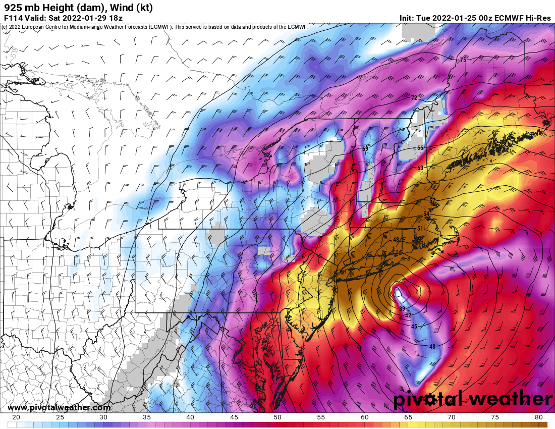
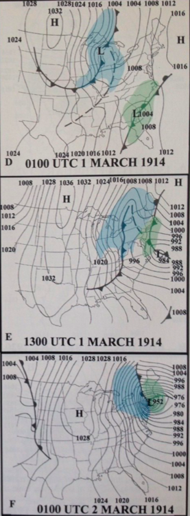
I believe this is the record low pressure for lower 48 / non-hurricane
-
potentially a little light snow Boston area late tonight /first thing tomorrow morning? 925 winds veer more out of the east .. maybe a coating, 1/4"? Would just be nice to see some flakes in the air
-
Thursday AM Jan 20 Anafront snow threat.
ma blizzard replied to Sey-Mour Snow's topic in New England
not even true, no one bothered to look at a sounding -
Thursday AM Jan 20 Anafront snow threat.
ma blizzard replied to Sey-Mour Snow's topic in New England
still shoveling out from this 6" but the flash freeze is making it really tough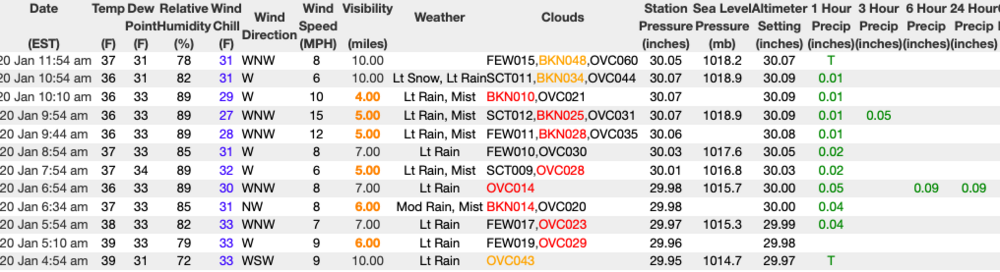
-
net gain?
-
-
even in Alaska ..
-
it for sure has to be, blaming the weather makes it easier