

Wurbus
-
Posts
666 -
Joined
-
Last visited
Content Type
Profiles
Blogs
Forums
American Weather
Media Demo
Store
Gallery
Everything posted by Wurbus
-
RGEM is still following this path. Model madness continues!
-
Looking like just some backside snow showers for the valley at this point.
-
The 00z HRRR just ran the low straight into the mountains and never transferred to the coast. When it ended, it was a 997 low sitting in West Virginia. It's the HRRR at long range....but don't think I've ever seen a low do that before. Needless to say, it wasn't a good run.
-
I couldn't imagine the excitement this board would have to track a storm like that. Honestly, the servers would probably crash a few times.
-
NAM was another Apps runner. Screws East TN, but plateau, middle TN, and portions on west TN still do well.
-
Yeah, looks good. Check the band over the plateau at 66. Wow!
-
RGEM looks almost identical to its 18z run
-
GEFS is not as enthused about middle and west TN.
-
Live look at the Euro.
-
I just don't want a WSW for Knox county issued from MRX. If that happens, 99% chance we aren't getting Winter storm warning totals. If they decide to go with a special weather statement or WWA, decent chance it over performs in Knox.
-
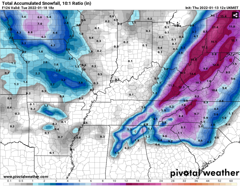
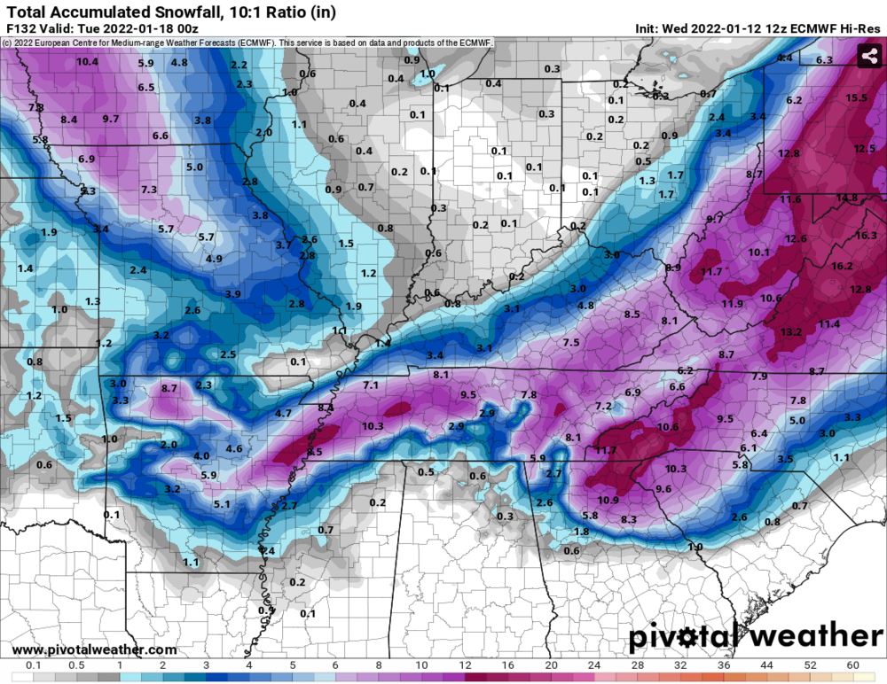
UKMet snow totals below. No love for middle/west TN
-
My money is on what CMC is showing here. Snow everywhere but the valley with that warm nose. I'll be happy with my 1-2 slushy accumulation and enjoy everyone else's pictures.
-
Just a slight difference in the Canadian vs GEFS for Nashville and West TN.
-
GFS went back to the wonky 12z run. Low bouncing all over the place.
-
That was a cold GFS run. It was below normal temps from 180 to the end of the run.
-
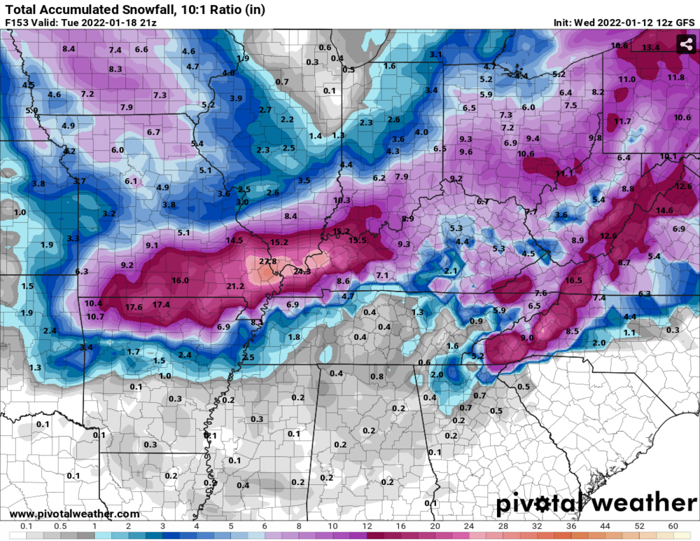
Won't let me post a screenshot for some reason, but the GEFS mean was 6-10 inches for almost all of East TN, plateau, Nashville, and most of North TN.
-
GEFS looks pretty good. Definitely some warm nose issues at the beginning of the event for the greater valley, but that is nothing new.
-
I'll cash that NAV/GEM in now!
-
For what it's worth (not much), NAM has the Low near Mobile at the end of it's run.
-
I just created a topic for this storm since it seems we will be tracking it for the next few days and we would stop cluttering this thread.
-
We have 2 camps at this moment. GFS/CMC is showing the low meandering across TN while it transfers to NC/VA and most everyone in TN gets mostly rain. The other scenario is Euro/UKmet/GEFS showing the low further south into mid-Mississippi and then transferring to around Myrtle Beach and brings all types of wintry precip from Memphis to Kingsport across the state. GFS Euro
-
So Dr. No and UKMet are the only ones saying yes at this point?
-
CMC is running and it doesn't look good. Low is over Memphis at 102. Looks similar to other OP models at this point
-
I'll say there are more big dogs for East TN on the GEFS that I thought there was going to be. I feel like this system is truly a boom or bust system though and will likely be more of a bust for most of us.


