Wurbus
-
Posts
666 -
Joined
-
Last visited
Content Type
Profiles
Blogs
Forums
American Weather
Media Demo
Store
Gallery
Everything posted by Wurbus
-
Historic Christmas Cold & maybe snow?! Dec 23rd-30th
Wurbus replied to Wurbus's topic in Tennessee Valley
No offense taken....in all likelihood I jumped the gun creating the thread since it usually doesn't pan out for us the closer we get to a potential event. I just have that feeling about this one though and if it doesn't pan out, I will never create a thread again for cursing the storm. -
Historic Christmas Cold & maybe snow?! Dec 23rd-30th
Wurbus replied to Wurbus's topic in Tennessee Valley
ECMWF pretty consistent on the cold after the front blows through. Temps crash and we stay below freezing for at least 3-4 days.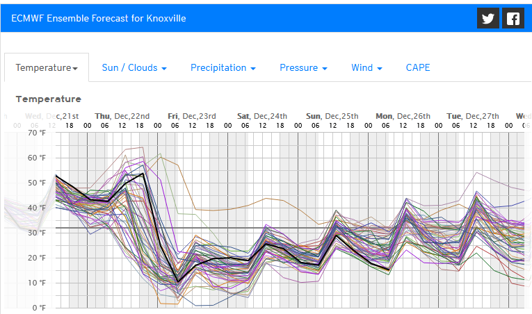
-
Historic Christmas Cold & maybe snow?! Dec 23rd-30th
Wurbus replied to Wurbus's topic in Tennessee Valley
Might by the last thread I ever create lol. -
December 2022 Medium/Long Range Pattern Discussion Thread
Wurbus replied to Carvers Gap's topic in Tennessee Valley
I created a thread for the cold and potential snow for this event. Hopefully it will all pan out and we all get clobbered, but the cold looks legit across all models regardless if the snow comes or not.- 582 replies
-
- 2
-

-

-
- snow
- freezing rain
- (and 4 more)
-
First time creating a thread and hoping for a Christmas Miracle! Models have been consistent on a huge cold shot coming in around the 23rd. Like always, the question is if we get any snow with this cold shot. GFS has shown the potentially for multiple rounds of snow, with an initial thumping arriving with the cold. CMC has the cold, but the system isn't amped up and we have some snow showers in the area. Euro has shown the system on the 23rd, but currently is cold and dry as of 00z 12/16. Regardless if any snow pans out, the cold looks to be real and potentially record breaking. Highs in the teens will be common from the 24th-26th with single digit (and sub-zero lows with snow pack). Below is the eye candy from the 12z GFS.
-
December 2022 Medium/Long Range Pattern Discussion Thread
Wurbus replied to Carvers Gap's topic in Tennessee Valley
Eye candy as Carver mentioned.- 582 replies
-
- 6
-
-

-
- snow
- freezing rain
- (and 4 more)
-
December 2022 Medium/Long Range Pattern Discussion Thread
Wurbus replied to Carvers Gap's topic in Tennessee Valley
Canadian took a step in the right direction as well. Not as amped up as GFS, but better than 12z. Round 2 just showed up for the Carolina's on the GFS.....- 582 replies
-
- 2
-
-
- snow
- freezing rain
- (and 4 more)
-
December 2022 Medium/Long Range Pattern Discussion Thread
Wurbus replied to Carvers Gap's topic in Tennessee Valley
00z GFS still on board!- 582 replies
-
- 9
-
-
-
- snow
- freezing rain
- (and 4 more)
-
December 2022 Medium/Long Range Pattern Discussion Thread
Wurbus replied to Carvers Gap's topic in Tennessee Valley
That was one cold GFS run. East TN below freezing from the 23rd-29th if that verifies.- 582 replies
-
- 6
-
-
- snow
- freezing rain
- (and 4 more)
-
December 2022 Medium/Long Range Pattern Discussion Thread
Wurbus replied to Carvers Gap's topic in Tennessee Valley
I'm supposed to be going to the Bills-Bengals Monday Night Football game on Jan 2nd in Cincinnati. I expected it to be cold, but hopefully this type of cold will relax a bit by then. -
Spring/Summer 2022 Medium/Long Range Forecast Discussion.
Wurbus replied to John1122's topic in Tennessee Valley
That was a cold 12z GFS run. Looks like we may skip Spring and go straight to Summer at this rate. -
March 11th-13th Winter Weather Event. Winter's last gasp?
Wurbus replied to Windspeed's topic in Tennessee Valley
MRX writeup for this event. I wound up with right around 8 inches at my house. What a way to close out winter! https://twitter.com/NWSMorristown/status/1503407140853145605?t=wL3iD8RhdjCNgC9zz81byA&s=19 -
March 11th-13th Winter Weather Event. Winter's last gasp?
Wurbus replied to Windspeed's topic in Tennessee Valley
Snowfall map per reports from MRX https://twitter.com/NWSMorristown/status/1502742413768601607?t=0r295HePyic_UJ0h7XdU_g&s=19 -
March 11th-13th Winter Weather Event. Winter's last gasp?
Wurbus replied to Windspeed's topic in Tennessee Valley
Always amazes me how quickly the snow will melt in the March sun. -
March 11th-13th Winter Weather Event. Winter's last gasp?
Wurbus replied to Windspeed's topic in Tennessee Valley
I ended up with about 8 inches. Snow already mostly melted off the roads around here though.
-
March 11th-13th Winter Weather Event. Winter's last gasp?
Wurbus replied to Windspeed's topic in Tennessee Valley
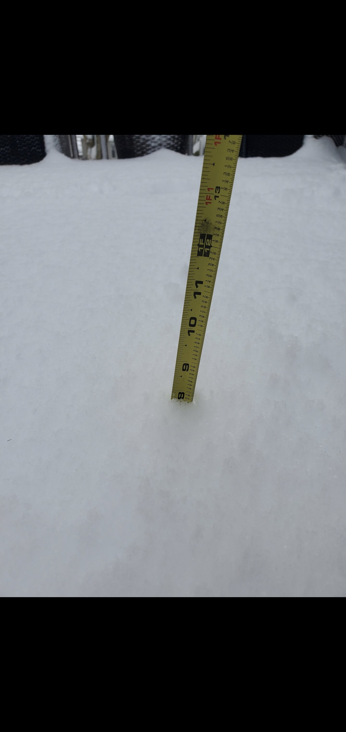
Going to get a little sleep. I measured right at 7 inches near Karns and it is still coming down. Overall, very impressive system! Most snow I can remember having in a long while. -
March 11th-13th Winter Weather Event. Winter's last gasp?
Wurbus replied to Windspeed's topic in Tennessee Valley
Probably at least 5 inches here.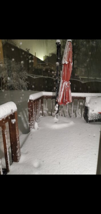
-
March 11th-13th Winter Weather Event. Winter's last gasp?
Wurbus replied to Windspeed's topic in Tennessee Valley
Probably the largest flakes so far in this band in Knoxville I've seen all night. -
March 11th-13th Winter Weather Event. Winter's last gasp?
Wurbus replied to Windspeed's topic in Tennessee Valley
I've got 4 inches on my deck. Still coming down pretty good. Might wind up with 6-8 if I get another 2-3 hours of this -
March 11th-13th Winter Weather Event. Winter's last gasp?
Wurbus replied to Windspeed's topic in Tennessee Valley
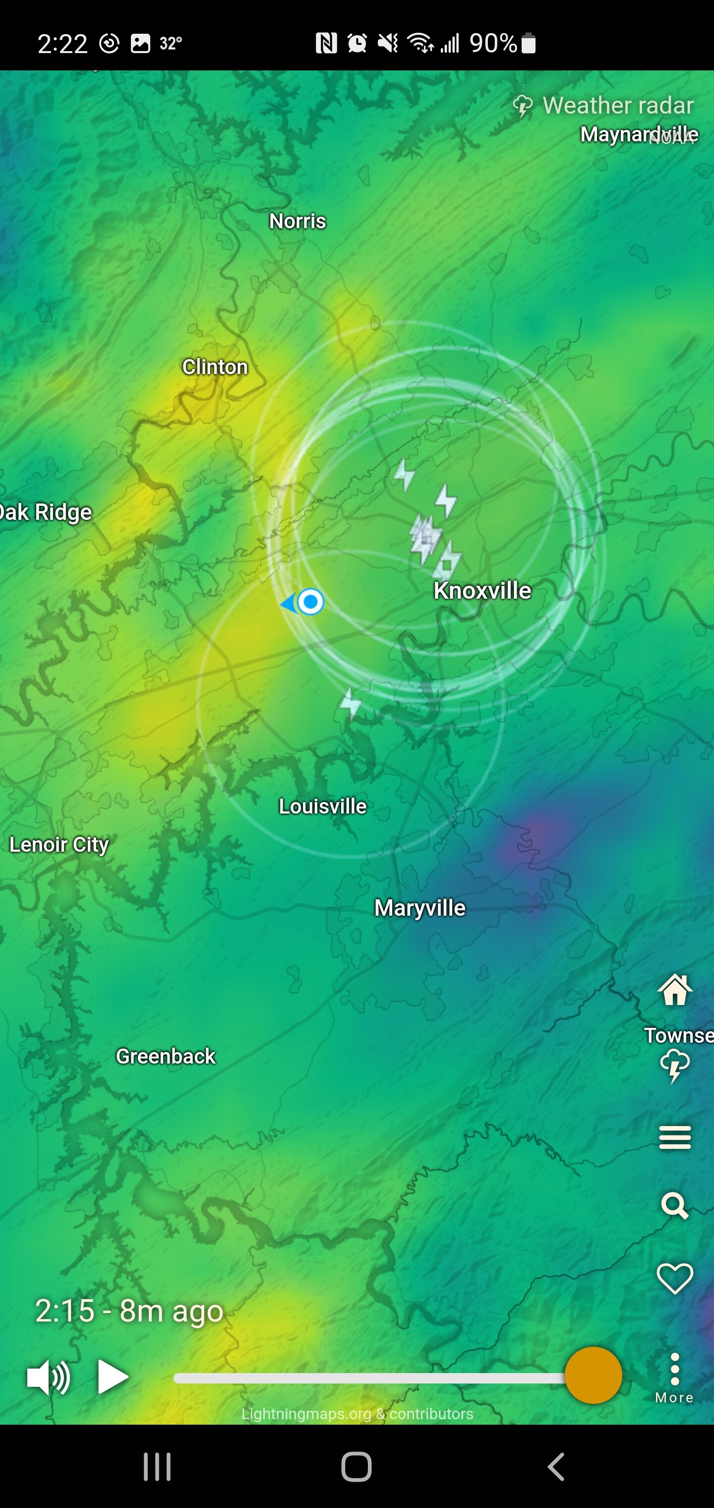
More thunder and lightning in Knoxville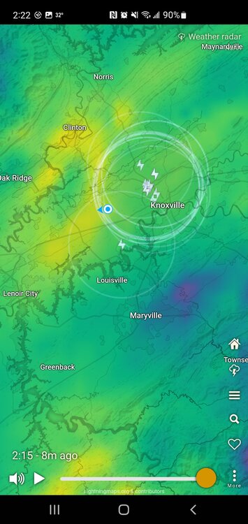
-
March 11th-13th Winter Weather Event. Winter's last gasp?
Wurbus replied to Windspeed's topic in Tennessee Valley
Probably have close to an inch and it is just puking fine snow. -
March 11th-13th Winter Weather Event. Winter's last gasp?
Wurbus replied to Windspeed's topic in Tennessee Valley
Yeah. I'm just watching the wind swirl from all different directions. Deck is already white in just 5 minutes -
March 11th-13th Winter Weather Event. Winter's last gasp?
Wurbus replied to Windspeed's topic in Tennessee Valley
The puddles will save you -
March 11th-13th Winter Weather Event. Winter's last gasp?
Wurbus replied to Windspeed's topic in Tennessee Valley
Just heard thunder and completely snow now. -
March 11th-13th Winter Weather Event. Winter's last gasp?
Wurbus replied to Windspeed's topic in Tennessee Valley
Snow starting to mix in here. I live in between Cedar Bluff and Karns