Wurbus
-
Posts
666 -
Joined
-
Last visited
Content Type
Profiles
Blogs
Forums
American Weather
Media Demo
Store
Gallery
Everything posted by Wurbus
-
March 11th-13th Winter Weather Event. Winter's last gasp?
Wurbus replied to Windspeed's topic in Tennessee Valley
Low pressure isn't as amped as the 18z run, but still looks to be a good track. -
March 11th-13th Winter Weather Event. Winter's last gasp?
Wurbus replied to Windspeed's topic in Tennessee Valley
Live look at all of us waiting on the NAM to finish. -
March 11th-13th Winter Weather Event. Winter's last gasp?
Wurbus replied to Windspeed's topic in Tennessee Valley
Looking at KNX, the mean held steady, but much more agreement between 5-7 inches and the lowest member is 1.17. -
March 11th-13th Winter Weather Event. Winter's last gasp?
Wurbus replied to Windspeed's topic in Tennessee Valley
I feel like a broken record, but the 21z SREF went up again for the plateau & SE KY. Slight uptick for KNX it appears. -
March 11th-13th Winter Weather Event. Winter's last gasp?
Wurbus replied to Windspeed's topic in Tennessee Valley
WBIR is showing what I thought MRX would show earlier. -
March 11th-13th Winter Weather Event. Winter's last gasp?
Wurbus replied to Windspeed's topic in Tennessee Valley
GEFS Mean. Pretty big increase along SE KY/Western Virginia -
March 11th-13th Winter Weather Event. Winter's last gasp?
Wurbus replied to Windspeed's topic in Tennessee Valley
That dark red streak might require a blizzard warning in northern mid-TN and SE KY -
March 11th-13th Winter Weather Event. Winter's last gasp?
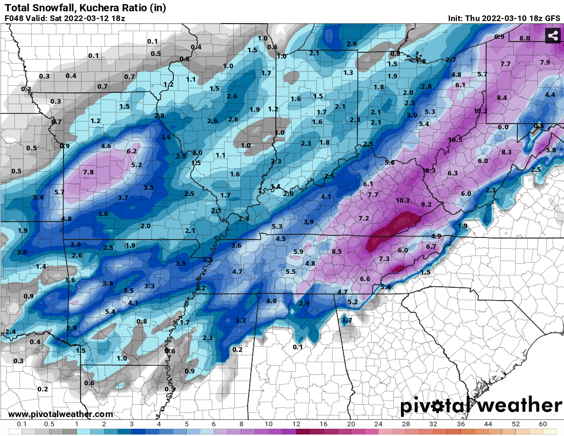
Wurbus replied to Windspeed's topic in Tennessee Valley
Ratio'd totals
-
March 11th-13th Winter Weather Event. Winter's last gasp?
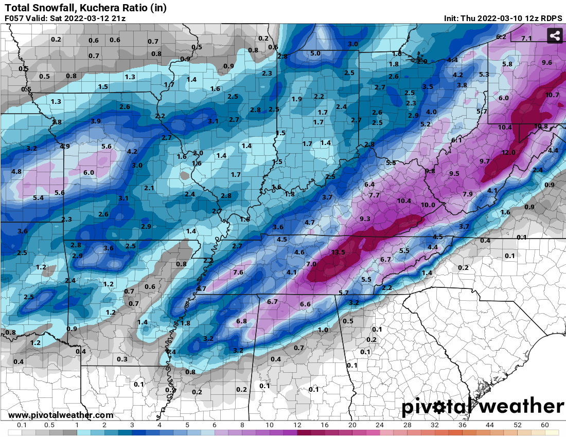
Wurbus replied to Windspeed's topic in Tennessee Valley
-
March 11th-13th Winter Weather Event. Winter's last gasp?
Wurbus replied to Windspeed's topic in Tennessee Valley
I'll take this look all day long. -
March 11th-13th Winter Weather Event. Winter's last gasp?
Wurbus replied to Windspeed's topic in Tennessee Valley
I'm actually shocked! -
March 11th-13th Winter Weather Event. Winter's last gasp?
Wurbus replied to Windspeed's topic in Tennessee Valley
I think NAM is going to be juiced. Already a 997 low in central Alabama at 36 -
March 11th-13th Winter Weather Event. Winter's last gasp?
Wurbus replied to Windspeed's topic in Tennessee Valley
MRX is going to say 1-3 for the valley with locally heavier amounts and issue a WWA and call it a day. I'd be surprised if they issue anything more than that today. They might even wait and let the night crew issue it. -
March 11th-13th Winter Weather Event. Winter's last gasp?
Wurbus replied to Windspeed's topic in Tennessee Valley
I'm sure they have some "in house" model they can use. -
March 11th-13th Winter Weather Event. Winter's last gasp?
Wurbus replied to Windspeed's topic in Tennessee Valley
Some nice big dogs on the SREF Plumes. Below are some of the mean totals. Nashville- 5.2 Plateau - 5.9 Chatt - 3.5 Knox - 5.1 Tri - 4 -
March 11th-13th Winter Weather Event. Winter's last gasp?
Wurbus replied to Windspeed's topic in Tennessee Valley
Looks like the 15z SREF held serve for the east, was slightly beefier for the plateau. -
March 11th-13th Winter Weather Event. Winter's last gasp?
Wurbus replied to Windspeed's topic in Tennessee Valley
GEFS Mean Surprised the plateau isn't larger. -
March 11th-13th Winter Weather Event. Winter's last gasp?
Wurbus replied to Windspeed's topic in Tennessee Valley
Not sure if I can pull this. -
March 11th-13th Winter Weather Event. Winter's last gasp?
Wurbus replied to Windspeed's topic in Tennessee Valley
The rate that the cold just pours in is pretty remarkable. Will go from mid-60s to freezing in almost 12 hours around Knoxville -
March 11th-13th Winter Weather Event. Winter's last gasp?
Wurbus replied to Windspeed's topic in Tennessee Valley
Winner Winner Chicken Dinner -
March 11th-13th Winter Weather Event. Winter's last gasp?
Wurbus replied to Windspeed's topic in Tennessee Valley
RGEM is still on board. Hammers the plateau!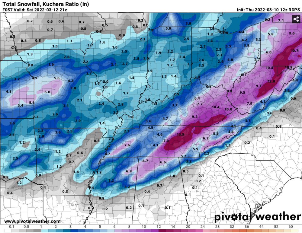
-
March 11th-13th Winter Weather Event. Winter's last gasp?
Wurbus replied to Windspeed's topic in Tennessee Valley
Wouldn't surprise me if it trended more to plateau/Nashville area. It has done that this whole winter it seems. -
March 11th-13th Winter Weather Event. Winter's last gasp?
Wurbus replied to Windspeed's topic in Tennessee Valley
48 HRRR isn't too bad either. Still some flurries/light snow showers hanging around at the end of the run.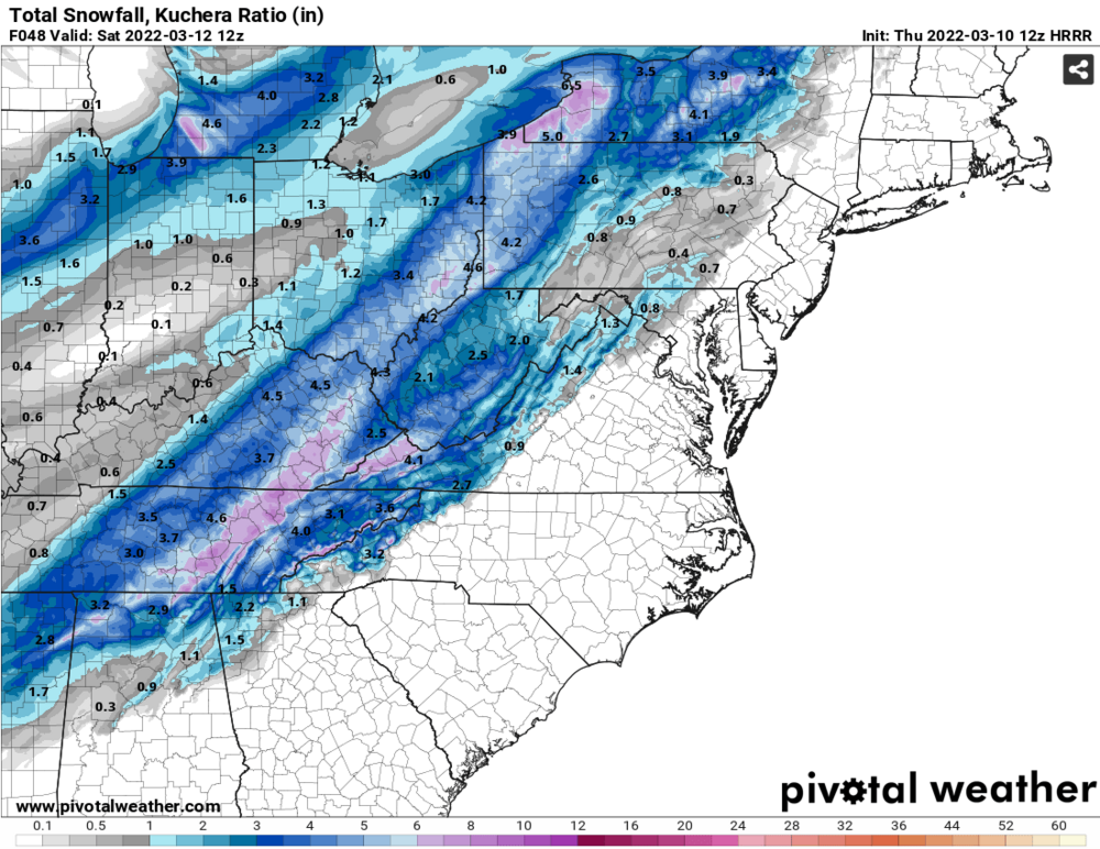
-
March 11th-13th Winter Weather Event. Winter's last gasp?
Wurbus replied to Windspeed's topic in Tennessee Valley
Even Chatt has over a 3" mean.Nashville is also at 4.2". Pretty good means across the board on that SREF run. -
March 11th-13th Winter Weather Event. Winter's last gasp?
Wurbus replied to Windspeed's topic in Tennessee Valley
18z GEFS mean increased over 12z. 12z is on the left.