

Daniel Boone
-
Posts
3,542 -
Joined
-
Last visited
Content Type
Profiles
Blogs
Forums
American Weather
Media Demo
Store
Gallery
Everything posted by Daniel Boone
-

December 2025 Short/Medium Range Forecast Thread
Daniel Boone replied to John1122's topic in Tennessee Valley
Here's Pennington. It was recorded at the Water Plant right on the banks of Powell River so, doesn't do Pennington gap itself justice really. https://www.ncei.noaa.gov/access/past-weather/Pennington gap VA -
December 2025 Short/Medium Range Forecast Thread
Daniel Boone replied to John1122's topic in Tennessee Valley
Here's data from national and State perspective. It's just Temperature. As you can see the Winter, Dec, Jan and Feb averaged slightly below normal. February alone was slightly above. Colder the further west in Southern Plains. I used to have the Data for Pennington. They've changed their Format for Stations Data so will have to find and look it up, also KTRIS. I used to have my own but lost it unfortunately while relocating. https://www.ncei.noaa.gov/access/monitoring/climate-at-a-glance/statewide/mapping/110/tavg/198402/3/rank -
December 2025 Short/Medium Range Forecast Thread
Daniel Boone replied to John1122's topic in Tennessee Valley
-
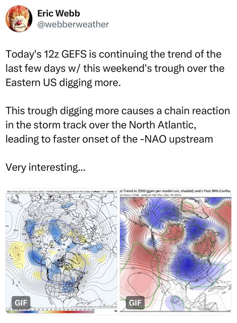
December 2025 Short/Medium Range Forecast Thread
Daniel Boone replied to John1122's topic in Tennessee Valley
Yeah, Webb I think it was commented today of how the deep trough this weekend should speed up the development of the -NAO. Someone posted it on the SE Sub. -
December 2025 Short/Medium Range Forecast Thread
Daniel Boone replied to John1122's topic in Tennessee Valley
Yep. If that occurs it'll be a pretty good indication of a pretty solid, great Winter imo. -
December 2025 Short/Medium Range Forecast Thread
Daniel Boone replied to John1122's topic in Tennessee Valley
Yeah, if they don't the Warmanista Drums will continue to beat loud. -
December 2025 Short/Medium Range Forecast Thread
Daniel Boone replied to John1122's topic in Tennessee Valley
1983-84 was below average Snowfall here and at KTRI. Had one bonafide Snowstorm in January. 6 inches. Another more scattered banded one where just east of Pennington gap got 5 inches while Pennington only an inch.. Other than that mainly a couple dustings to an inch. February had some very warm days in the 70's . March had one Storm with thunder snow but was rain snow mixed below 2000 feet. -
Yeah. Could be MJO related if some Models are correct in their back into Ph.8 Depiction. Rossby and Kelvin Waves are really throwing a monkey wrench in the Guidance looks like.
-
December 2025 Short/Medium Range Forecast Thread
Daniel Boone replied to John1122's topic in Tennessee Valley
My Sister used to live near you in Humboldt. I recall Ice Storms seemed more prevalent there than here back then (80's). -
December 2025 Short/Medium Range Forecast Thread
Daniel Boone replied to John1122's topic in Tennessee Valley
Yeah I disagree with some of their changes. JKL still issues frost/freeze advisories for first widespread of Season. -
December 2025 Short/Medium Range Forecast Thread
Daniel Boone replied to John1122's topic in Tennessee Valley
Yeah, 2013-14 was a cold, snowy January and into February. -
December 2025 Short/Medium Range Forecast Thread
Daniel Boone replied to John1122's topic in Tennessee Valley
I agree completely man. NEPAC and western ridge squeeze play of the Pac Jet forcing downsloping imo. Also helping force that ridge to elongate eastward somewhat. Allows for Chinooks. If HLB sets up , even if that Pac Jet atmospheric ruver were to continue, it's going slow and back and buckle the Flow to some degree, whether alot or some depending on Blocking Strength. -
December 2025 Short/Medium Range Forecast Thread
Daniel Boone replied to John1122's topic in Tennessee Valley
Surely not, lol -
December 2025 Short/Medium Range Forecast Thread
Daniel Boone replied to John1122's topic in Tennessee Valley
My bad, I said Golf Matthew. Sorry man, I'd forgot which one asked. You're welcome ! -
December 2025 Short/Medium Range Forecast Thread
Daniel Boone replied to John1122's topic in Tennessee Valley
I was actually replying to Golf as he questioned what the cold phases were. As far as the lw pattern, yeah, I agree although we do have that Aleutian HP but not the typical Nina Ridging up to there. Odd Pattern. Probably a product of the Waves you mentioned earlier messing with the MJO. Interference. -
December 2025 Short/Medium Range Forecast Thread
Daniel Boone replied to John1122's topic in Tennessee Valley
Winter as a whole MJO Cold Phases: 8 1 2 . -
December 2025 Short/Medium Range Forecast Thread
Daniel Boone replied to John1122's topic in Tennessee Valley
Yeah. Would be nice to have a full blown MJO Ph8 Pattern. -
December 2025 Short/Medium Range Forecast Thread
Daniel Boone replied to John1122's topic in Tennessee Valley
Yeah, there's apparently some mixed up data as there's different locations from different Modeling. I think the Kelvin and Rossbys are alot of our problems as Jax pointed out. Makes sense. -
December 2025 Short/Medium Range Forecast Thread
Daniel Boone replied to John1122's topic in Tennessee Valley
Thanks brother ! -
December 2025 Short/Medium Range Forecast Thread
Daniel Boone replied to John1122's topic in Tennessee Valley
Models have been showing that Block shifting Eastward to being centered over Alaska. I made a post recently that we needed that to happen and get rid of any GOA Low. If that doesn't happen, yeah Trough should drop in the West. There have been rare times as I'm sure you know, where other Variables altered the typical outcome of Aleutian Ridge equates to western Trough however. Carvers can better describe what looks be be transpiring and maybe touch on those Variable's. I'm just too tired and sick to present everything myself. Carvers is much better than I am and a Master at that. -
December 2025 Short/Medium Range Forecast Thread
Daniel Boone replied to John1122's topic in Tennessee Valley
Good,valid point. Post this in the Main Forum and you'll have many going Nuts over there ; particularly the Warmanista and GW brainwashed One's. They'd probably justify the Model's doing that. Fact is, GW is real to a degree but, the Cause and Forecasted Rate is off. Not to say your Post is about GW, just giving an Opinion on why you're right on your Suspicion. -
December 2025 Short/Medium Range Forecast Thread
Daniel Boone replied to John1122's topic in Tennessee Valley
Yeah, had the same Pattern came later that we've been in it's possible if not probable we'd gotten Snow from the cold rain and mix one's we got. I remember doing same as you. When the cold dropped down from North Dakota and Minnesota. Fun times watching Margie Isom . Use to Snow would hit Memphis then Chatt and spread up the Valley. The whole Valley would get in on many of the Snow storm's. Miller A's were more prevalent. -
December 2025 Short/Medium Range Forecast Thread
Daniel Boone replied to John1122's topic in Tennessee Valley
'76-77 and 77-78 were just unreal for this Area. Theyveere great Northern like Winters. River's, Creeks and Ponds were frozen completely over and thick. You could walk on them ! Constant Cold. I'm thinking the MJO hung out in cold Phases. Blocking was strong in 76-77 but oddly the NAO was neutral to slightly positive. Strong -AO Both. Strong +PNA as well. Not surprising, '77-78 was my Snowiest Winter with 72" recorded just west of Pennington gap. -
December 2025 Short/Medium Range Forecast Thread
Daniel Boone replied to John1122's topic in Tennessee Valley
Coz has always been a good long Ranger. Could be right about last half. If so, even with the mild period, it would turn out overall a cold Winter, especially going by this Era's Standards. Glad you had a decent Score over there with this one buddy ! You were under the same bands that moved over here. -
December 2025 Short/Medium Range Forecast Thread
Daniel Boone replied to John1122's topic in Tennessee Valley
A Modification of the current one would work actually. Pop that HP on east into Alaska and get rid of any semblance of a GOA Low and strengthen Blocking upstream. That way the Clipper's and Miller B's would travel further South. The worry of a complete reshuffle is we never get back to a base Eastern Trough. What's really needed is a tall Western Ridge connecting with, in conjunction with or connecting with the Alaskan HP. A -AO as well. Another, although not neccesary but helps, is formidable blocking in the NAO Domain, preferably with a 50-50 or thereabouts Low. That would work for us. An active STJ in the Mix would raise the odds for heavy Snowfalls. It has been weak or lacking in those Area's during this cold Stretch.

