-
Posts
3,536 -
Joined
-
Last visited
Content Type
Profiles
Blogs
Forums
American Weather
Media Demo
Store
Gallery
Everything posted by Daniel Boone
-

December 2025 Short/Medium Range Forecast Thread
Daniel Boone replied to John1122's topic in Tennessee Valley
I saw where Bamwx is buying that Depiction. He's getting backlash of course. I recall the Winters when we got cold and Snow with a GOA Low in Place and that was how it was done. Systems would track NW to SE down the Jet . Sometimes Systems would traverse the STJ and phase in the lower Ms Valley. Those were the big ones if you got one in that Pattern. However, I recal some 3-6 inches with the Miller B and Clippers in that Pattern. -

December 2025 Short/Medium Range Forecast Thread
Daniel Boone replied to John1122's topic in Tennessee Valley
That's the evolution of getting that pesky GOA Low moved. Force that sucker South and West . The Central Ridge gets forced back West from the classic blocking that looks to be setting up..if that 50-50 is real, that'll be the real deal blocking Pattern. -

December 2025 Short/Medium Range Forecast Thread
Daniel Boone replied to John1122's topic in Tennessee Valley
Thanks brother ! I hope and pray your Wife gets well and you stay healthy. Dr said Flu was bad here too. He said Covid was too but it's Symptoms haven't been as bad as the other Viruses. -

December 2025 Short/Medium Range Forecast Thread
Daniel Boone replied to John1122's topic in Tennessee Valley
A -AO allows for the Cold in the Arctic and Northern Lats to spill further South. +AO tends to keep it bottled up North. It's not guaranteed cold here as if other Drivers force a Trough in the West it can still be mild here. It however increases odds of the real Cold air of reaching the lower Latitudes by a good margin. Doesn't mean you can't get it to get cold , or even snow in our area with a +AO as sometimes with the right 500 mb Setup CPF can occur. -

December 2025 Short/Medium Range Forecast Thread
Daniel Boone replied to John1122's topic in Tennessee Valley
Yeah. I still have this Upper Respiratory Virus. 12 days so far. Dr says it has now led to a Sinus and bronchial Infection. So, yeah would be a nice break with a mild period and more moisture in the air. Be careful out and about folks. Alot of nasty stuff going around. Dr even said the regular cold virus is stronger and harder to shake than usual. -

December 2025 Short/Medium Range Forecast Thread
Daniel Boone replied to John1122's topic in Tennessee Valley
Thanks Man ! Great Information !!! -

December 2025 Short/Medium Range Forecast Thread
Daniel Boone replied to John1122's topic in Tennessee Valley
Yeah, the most amazing imo was Knoxville hitting -24. -27 at my house west of Pennington gap Va. Couple -30 readings and a -32 reported in rural Wise County near Norton as I recall. What did you record there John ? -

December 2025 Short/Medium Range Forecast Thread
Daniel Boone replied to John1122's topic in Tennessee Valley
Yeah, eastern areas(east of the TN Valley )may very well not see much of the warm-ups at all. I think, as you alluded to earlier as well, we get in on some of them until Blocking asserts. I'm betting we see a couple very warm Days (60's) with maybe 70's western area's. I made a comment over in the MA Sub how we could get around the NPAC GOA Low problems as they're down on that being there as many are. Blocking is the key .Secondly, MJO in cold Phases . Also, gave you a Shout-out about your Pac NW Feedback Idea and how it could very well be the Case. If Jeffs still viewing, what's your take on what Carver's Ideas are irt the Feedback possibility of the Model's in the Pac NW ? -
Down to 6 here this Morning. 4 at Daughters house down in a Valley. Saw couple 2 and 3 degree's on Couple Weather Station's in the in the County.
-

December 2025 Short/Medium Range Forecast Thread
Daniel Boone replied to John1122's topic in Tennessee Valley
Yeah, we need those Features Opposite of where they are. Hopefully guidance is off with that Depiction but, looks pretty likely until Blocking sets up late Month or those features shift. -

December 2025 Short/Medium Range Forecast Thread
Daniel Boone replied to John1122's topic in Tennessee Valley
Just carrying on there man. Yeah, that's been the fault during the entire cold period overall. Southern Virginia from about Lebanon Eastward to Va Beach have had a great Stretch with plenty of Snow. -
Yeah true. Hopefully enough pressure from a favorable MJO and Blocking will get rid of those flies in the Ointment. Once the Nina weakens the STJ should strengthen.
-
Need it over Alaska and the GOA Low over the Aleutians.
-
We gotta get rid of that GOA Low and slow down the Pac Jet. The sooner the better . I think, providing the MJO is in cold Phases we'd be alright then. As is , strong Blocking may do the trick.
-
Models have really struggled this late fall/ early Winter. Carvers gap in the Tn Valley Sub brought up something that could be right. Feedback in The Pac NW. Watch the Cycle's and check out the Runs that keep the East colder. Look at the difference in the PAC NW. Also, Webb has some rather interesting Ideas as well. We , no doubt need to shake any semblance of a GOA Low as we all know but, it is possible to work around it until we do. Chill covered those. The MJO back in Ph 8 hopefully helps as well.
-

December 2025 Short/Medium Range Forecast Thread
Daniel Boone replied to John1122's topic in Tennessee Valley
Hopefully the Ridge doesn't do like the guy in thaht Song, I get knocked down, but I get up again, ain't nothin gonna slow me down ". Lol. I just had to man ! -

December 2025 Short/Medium Range Forecast Thread
Daniel Boone replied to John1122's topic in Tennessee Valley
That happened in '95-96 as we know. It would Snow and be cold a few Days, warm up rain and even flood some a time or two then cold and snow again. Blocking was the big difference maker that Winter. If we can get strong persistent blocking, I think we'll score some good Snow Events. -

December 2025 Short/Medium Range Forecast Thread
Daniel Boone replied to John1122's topic in Tennessee Valley
The Pennington gap Data for the past 15 years has gotten flat out terrible. We've addressed that before. It's really showing it's print on the Model's now too. The Station Siting is terrible and the Observer's are awful. It's Located at the Sewer Plant now. I'll get a Picture one day and you'll see how off the Siting is from Official Guidelines. -

December 2025 Short/Medium Range Forecast Thread
Daniel Boone replied to John1122's topic in Tennessee Valley
Yeah. I see you found it. Yeah, that would have been the 2 I recall although Pennington itself got 6 from the first one. I don't recall the Feb. One's being what is shows but could of been at that location. I was thinking more 70s in Feb but apparently it was a long stretch of upper 60s and a 70 there. As you can see snowfall was below average. Average in Pennington then was 19.7" as I recall. -

December 2025 Short/Medium Range Forecast Thread
Daniel Boone replied to John1122's topic in Tennessee Valley
Here's Pennington. It was recorded at the Water Plant right on the banks of Powell River so, doesn't do Pennington gap itself justice really. https://www.ncei.noaa.gov/access/past-weather/Pennington gap VA -

December 2025 Short/Medium Range Forecast Thread
Daniel Boone replied to John1122's topic in Tennessee Valley
Here's data from national and State perspective. It's just Temperature. As you can see the Winter, Dec, Jan and Feb averaged slightly below normal. February alone was slightly above. Colder the further west in Southern Plains. I used to have the Data for Pennington. They've changed their Format for Stations Data so will have to find and look it up, also KTRIS. I used to have my own but lost it unfortunately while relocating. https://www.ncei.noaa.gov/access/monitoring/climate-at-a-glance/statewide/mapping/110/tavg/198402/3/rank -

December 2025 Short/Medium Range Forecast Thread
Daniel Boone replied to John1122's topic in Tennessee Valley
-

December 2025 Short/Medium Range Forecast Thread
Daniel Boone replied to John1122's topic in Tennessee Valley
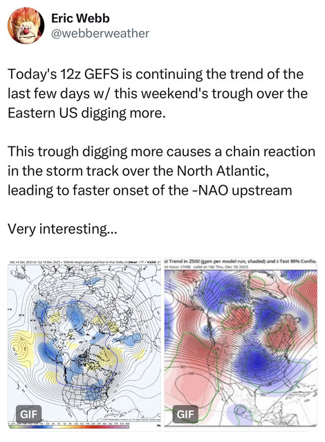
Yeah, Webb I think it was commented today of how the deep trough this weekend should speed up the development of the -NAO. Someone posted it on the SE Sub. -

December 2025 Short/Medium Range Forecast Thread
Daniel Boone replied to John1122's topic in Tennessee Valley
Yep. If that occurs it'll be a pretty good indication of a pretty solid, great Winter imo. -

December 2025 Short/Medium Range Forecast Thread
Daniel Boone replied to John1122's topic in Tennessee Valley
Yeah, if they don't the Warmanista Drums will continue to beat loud.


