

Metasequoia
-
Posts
785 -
Joined
-
Last visited
Content Type
Profiles
Blogs
Forums
American Weather
Media Demo
Store
Gallery
Everything posted by Metasequoia
-
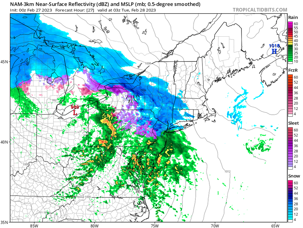
Thundersnow in Battery Park City!
-
Another possible outcome...hopefully not realized.
-
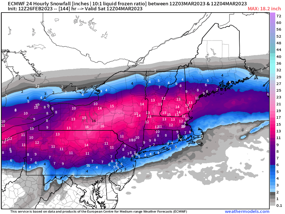
Listening to people's reactions as the Euro was running, it sounded like the storm went up the St Lawrence Seaway...granted we weren't Jackpotted.
-
The 12Z Euro did bump north quite a lot, but verbatim, it's still a decent snow for NYC and north. Of course things could keep moving north...
-
Looks like a substantively better GFS run to me. Best GFS run in many cycles.
-
https://www.weather.gov/nerfc/snow
-
I don't hate where we're sitting 6 days out. There's a lot support for a large storm coming up the east coast with a lot of blocking in place. The models are likely going to flop all over the place for several days to come. Too early to throw in the towel or get too excited.
-
Sleeting in lower Manhattan...maybe still some rain mixed in.
-
Probably referring to the 1888 blizzard. 1993 was a KU for many though and you'd agree, pretty significant for NYC.
-
OZ NAM with a couple ticks south. Not that many want sleet and freezing rain.
-
Looks like the latest RAP has surface temps below freezing in NYC for most of the storm...tough to tell on Pivotal though.
-
Let's stop calling off the storm before it happens...unless you are pining away for all snow, then it is over. That was never really a possibility. The latest HRRR is not a bad look for a real winter day for metro and LI north.
-
Yea, not a good run for snow. Sleet will do though. Pretty close to being a soaker unfortunately.
-
OZ Canadian actually looked better. Parent low was weaker and further south.
-
Yup. This looks like how these types of systems play out for NYC south. Still 4 plus days out I guess...
-
Still think this type of system favors northern areas for snow, but we are still 5 days away. That's plenty of time for a shift south or north for that matter.
-
It seems like these overrunning storms don't result in much snow for NYC. Hudson Valley and New England do well...sometimes the Mid-Atlantic. Hopefully we all do well...if that's even possible with such a storm
-
2/13 Light/Moderate Snowfall Nowcasting & Observations
Metasequoia replied to Northof78's topic in New York City Metro
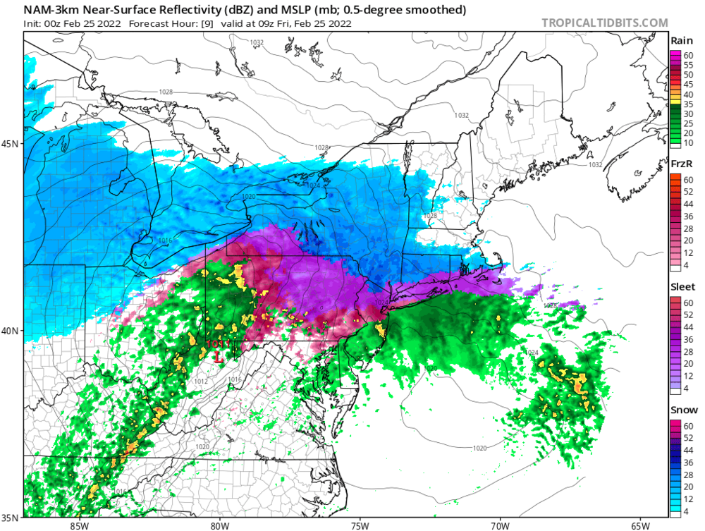
About 2 inches in Battery Park City on surfaces other than streets and sidewalks. Trees are covered. Good to keep expectations in check...nice modest snowfall. -
2/13 Light/Moderate Snowfall Nowcasting & Observations
Metasequoia replied to Northof78's topic in New York City Metro
Sidewalks are also finally getting covered in lower Manhattan. Quite beautiful with all the trees covered. It's nice to have a snowfall beat expectations. -
2/13 Light/Moderate Snowfall Nowcasting & Observations
Metasequoia replied to Northof78's topic in New York City Metro
Moderate snow in southern Manhattan. All paved surfaces are wet, but everything else is covered. Not that there is much grass or soil for snow to accumulate on, but whatever. Better than I expected. -
2/13 Light/Moderate Snowfall Nowcasting & Observations
Metasequoia replied to Northof78's topic in New York City Metro
I'm keeping my expectations in check for Manhattan where I live. You are in a much better position though. -
2/13 Light/Moderate Snowfall Nowcasting & Observations
Metasequoia replied to Northof78's topic in New York City Metro
I just doubt the ground will be cold enough on Sunday and the snow heavy enough to accumulate much if at all in NYC. If the low strengthens more than expected and/or tracks further NW, that might make a difference. -
2/13 Light/Moderate Snowfall Nowcasting & Observations
Metasequoia replied to Northof78's topic in New York City Metro
Mid to upper 50s on Saturday, so mostly white rain in NYC. Grass and cartops elsewhere? -
I prefer snow, but I like a good sleetstorm. It's like really low ratio snow...which will do. The 2017 half foot sleetstorm in NYC was epic.
-
Pretty nice look and the low is only at 998 mb.


