

Metasequoia
-
Posts
785 -
Joined
-
Last visited
Content Type
Profiles
Blogs
Forums
American Weather
Media Demo
Store
Gallery
Everything posted by Metasequoia
-
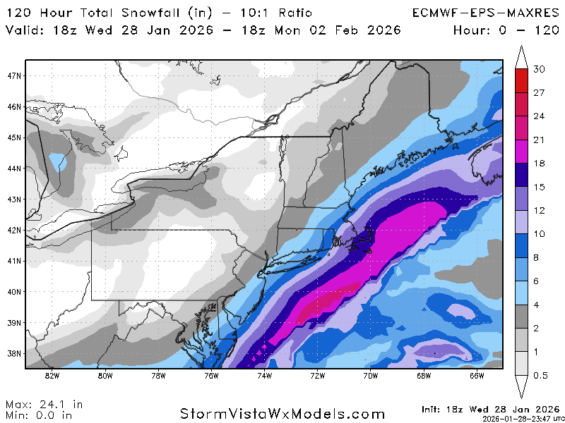
January 30th- Feb 1st ULL and coastal storm obs
Metasequoia replied to JoshM's topic in Southeastern States
Looks like y'all in Raleigh are finally in for some fun. -
The “I bring the mojo” Jan 30-Feb 1 potential winter storm
Metasequoia replied to lilj4425's topic in Southeastern States
I'm pulling for Raleigh! I lived there for a decade in the 90s and 2000s before moving to NYC. Kind of looks like the bands of snow from the developing coastal and bands to the west are about to merge over Raleigh. That would give Raleigh a shot at something decent. -
-
FWIW - NOAA gives NYC a ~50% chance of snow for Saturday night and Sunday.
-
From NE folk:
-
For anyone doing PBPs that aren't seasoned at this, let's hold off on pronouncements until it's obvious how the model run is progressing.
-
Possible coastal storm centered on Feb 1 2026.
Metasequoia replied to Typhoon Tip's topic in New England
That was a fantastic storm that was almost a complete surprise. I lived in Raleigh at the time... a couple hours before the first flakes, the forecast was for mostly rain. -
Per NOAA, CP ended the day with 1.82 inches.
-
Snow showers with the sun out...
-
The GFS has intermittently shown a big storm impacting the region for almost a week now. The 21st, 23rd, and 24th model runs looked good... just not the recent runs.
-
CP has recorded 1.61 LQP as of 8PM. That's an impressive Winter storm... and not that common for NYC.
-
Visibility has reduced further. Mostly snow in Battery Park City.
-
Visibility reduced again in southern Manhattan... probably a sleet and snow mix.
-
Extreme Cold, Snow & Sleet: SECS 1/24 - 1/26
Metasequoia replied to TriPol's topic in New York City Metro
Mostly sleet in southern Manhattan... pretty heavy. -
Sleet and snow battle in Battery Park City.
-
Extreme Cold, Snow & Sleet: SECS 1/24 - 1/26
Metasequoia replied to TriPol's topic in New York City Metro
Since this storm will be dumping heavy snow from the Texas through New England, the NESIS value might be huge. Category 3 at least... maybe 4. Although, I wonder how far outside of the northeast, NESIS applies to. I thought to the Midwest... https://www.ncei.noaa.gov/access/monitoring/rsi/nesis -
Extreme Cold, Snow & Sleet: SECS 1/24 - 1/26
Metasequoia replied to TriPol's topic in New York City Metro
The QPF has consistently been at least 1 inch for sure. Also, seems like it has been increasing for days. -
Extreme Cold, Snow & Sleet: SECS 1/24 - 1/26
Metasequoia replied to TriPol's topic in New York City Metro
Another Ukie run, another NYC snow hole. Having said that... it's a colder solution, which is welcome. -
Extreme Cold, Snow & Sleet: SECS 1/24 - 1/26
Metasequoia replied to TriPol's topic in New York City Metro
It's good to keep expectations in check... and a 24 hour storm with 6 to 10 inches of snow and sleet (followed by below freezing temps for a week) would typically thrill everyone on here. -
Jan 24-26 Weekend Snow and Sleetfest Model Thread Part Tres
Metasequoia replied to H2O's topic in Mid Atlantic
Snow is the best, but one of the things I like about sleet is how loud it is. It adds another dimension to storms. -
Extreme Cold, Snow & Sleet: SECS 1/24 - 1/26
Metasequoia replied to TriPol's topic in New York City Metro
I get that this storm will have a dry slot, but come on, right? Too consistent run to run... it's like the British are screwing with New Yorkers. -
Extreme Cold, Snow & Sleet: SECS 1/24 - 1/26
Metasequoia replied to TriPol's topic in New York City Metro
Locked in for an NYC snow hole -
Extreme Cold, Snow & Sleet: SECS 1/24 - 1/26
Metasequoia replied to TriPol's topic in New York City Metro
It was March 2017... NYC got 5 or so inches of sleet on top of a couple inches of snow. 2 inches of LQP. Lots of thundersleet... -
Extreme Cold, Snow & Sleet: SECS 1/24 - 1/26
Metasequoia replied to TriPol's topic in New York City Metro
Freezing rain isn't so much fun. However, I think of sleet as low ratio snow that helps keep the snow pack around longer. -
Extreme Cold, Snow & Sleet: SECS 1/24 - 1/26
Metasequoia replied to TriPol's topic in New York City Metro
QPF continuing to increase...


