EastonSN+
-
Posts
8,666 -
Joined
-
Last visited
Content Type
Profiles
Blogs
Forums
American Weather
Media Demo
Store
Gallery
Everything posted by EastonSN+
-
 FWIW channel 8 news said the sleet will make it up to Willamantic now, but most of the snow would have already fallen.
 -
Did Boston ever get a 30 inch storm?
-
2 inch and hour band starting here now.
-
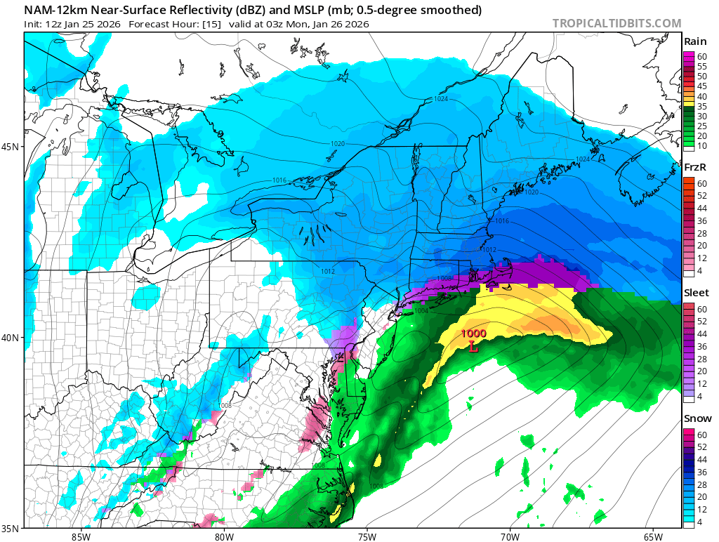
Think DC had 3.4 as of 7am and has been sleet for a while. NAM was correct so far with the warm punch.
-
For us coasties DC and Baltimore have busted low on totals due to a much quicker turnover.
-
For us coasties the NAM was the quickest to turn DC to sleet and was correct. So probably more reliable than the HRRR or RAP.
-
The accumulation difference between our towns is going to be wild. NAM has a massive cut off.
-
Read their forum they confirmed that the NAM was correct with the thermals FWIW.
-
Extreme Cold, Snow & Sleet: SECS 1/24 - 1/26
EastonSN+ replied to TriPol's topic in New York City Metro
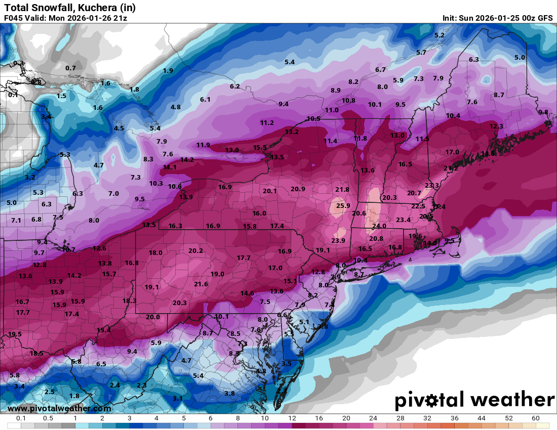
GDPS and I am off.
-
Extreme Cold, Snow & Sleet: SECS 1/24 - 1/26
EastonSN+ replied to TriPol's topic in New York City Metro
March 2017 had 7.5 of snow followed by 2.0 of snow sleet mix for a total of 9.5. Sleet snow mix DOES accumulate. -
Extreme Cold, Snow & Sleet: SECS 1/24 - 1/26
EastonSN+ replied to TriPol's topic in New York City Metro
Sleet got here faster offset by a heavier thump -
Extreme Cold, Snow & Sleet: SECS 1/24 - 1/26
EastonSN+ replied to TriPol's topic in New York City Metro
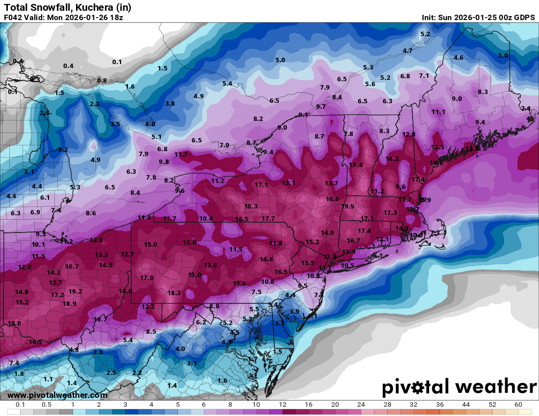
GFS increased totals even though had more sleet due to heavier snow initially.
-
Extreme Cold, Snow & Sleet: SECS 1/24 - 1/26
EastonSN+ replied to TriPol's topic in New York City Metro
Gonna be a lot of snow and sleet regardless and will stick around for a long time. -
Extreme Cold, Snow & Sleet: SECS 1/24 - 1/26
EastonSN+ replied to TriPol's topic in New York City Metro
I am in CT so about 17 for me on that but I am rooting for CPK. -
Extreme Cold, Snow & Sleet: SECS 1/24 - 1/26
EastonSN+ replied to TriPol's topic in New York City Metro
Darn RDPS is warmer. Though still respectable.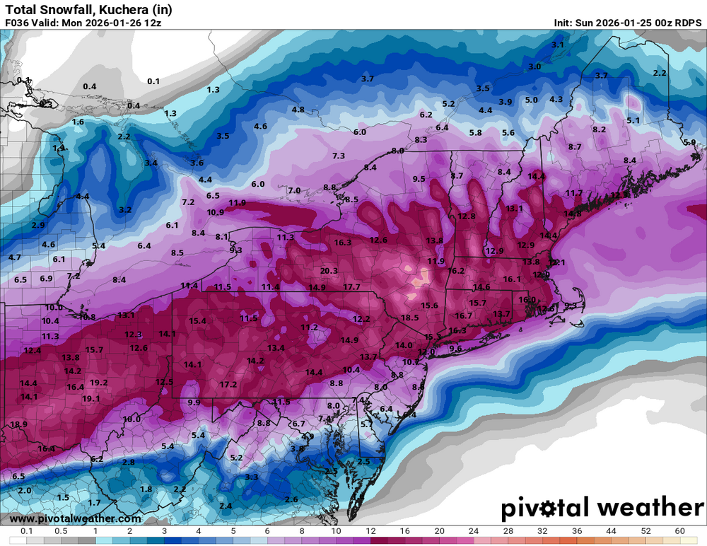
-
Extreme Cold, Snow & Sleet: SECS 1/24 - 1/26
EastonSN+ replied to TriPol's topic in New York City Metro
Darn RDPS is warmer. -
Extreme Cold, Snow & Sleet: SECS 1/24 - 1/26
EastonSN+ replied to TriPol's topic in New York City Metro
Shocked how great the trends have been !! -
Extreme Cold, Snow & Sleet: SECS 1/24 - 1/26
EastonSN+ replied to TriPol's topic in New York City Metro
Also just because the sleet line reaches the city that does not mean the accumulation ends. Sleet snow mix will still accumulate just slower. -
WOW big increase for CT coastline on the RDPS, EURO and EURO AI. That would give ALL of New England a foot plus!!
-
WOW just saw the RDPS, EURO and EURO AI. Shocked they moved THAT far south.
-
Extreme Cold, Snow & Sleet: SECS 1/24 - 1/26
EastonSN+ replied to TriPol's topic in New York City Metro
Thundersleet reported in Texas!!!! -
Extreme Cold, Snow & Sleet: SECS 1/24 - 1/26
EastonSN+ replied to TriPol's topic in New York City Metro
The UKMET is the coldest and was a hold from 12z. Interesting. -
Extreme Cold, Snow & Sleet: SECS 1/24 - 1/26
EastonSN+ replied to TriPol's topic in New York City Metro
Do u happen to have the 12z for comparison -
Extreme Cold, Snow & Sleet: SECS 1/24 - 1/26
EastonSN+ replied to TriPol's topic in New York City Metro
Yeah I just did the comparison the GFS was about 20 miles south and colder. Just that SMALL warm punch lol.