EastonSN+
-
Posts
9,109 -
Joined
-
Last visited
Content Type
Profiles
Blogs
Forums
American Weather
Media Demo
Store
Gallery
Everything posted by EastonSN+
-

2026-2027 Super El Nino
EastonSN+ replied to Stormchaserchuck1's topic in Weather Forecasting and Discussion
I will be honest, I am looking forward to energy savings. Also, 2 of the last 3 super events had a KU event. Conscious that this is a very small sample size, however I would roll the dice winter with the active sourhern jet. Perhaps I am just greedy after the tri state area experienced 2 KU events this past winter. -
How do you know what I consider cold? Is there a defined temperature for it to be considered cold this time of year? Yes if we lived in Alaska I may not consider it cold.
-
Great, I hate this cold and dreary weather. Happy we had our 2nd above average snowfall winter this decade. Already ahead of the 1970 through 1999 pace (4 in 30 years).
-
We got 1 to 3 March 9, 2022. Its every other decade. 2030 through 2039 will likely be similar to 2010 through 2019 which was a great decade for March snow).
-
I found it interesting that only 4 winters since 1970 had 5 or more inches of snow for both December and March. Its usually one or the other except for extreme winters like 93/94, 95/96, 02/03 and 17/18. Even the great winter of 13/14 was a shutout in March.
-
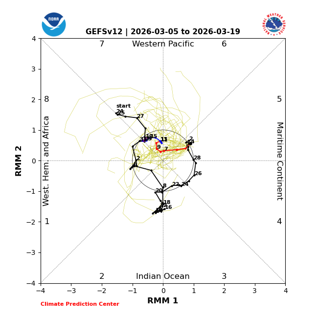
Yeah looks like the PV consolidated
-
Wanted to share from SACRUS in NY forum.
-
A- Easton CT. 52.7 inches. I grade purely on snowfall, with A+ reserved for 60+.
-
A- Easton CT. 52.7 inches. I grade purely on snowfall, with A+ reserved for 60+.
-
December 2024 and February 2025 were officially below average.
-
Two years in a row of below normal Dec, Jan and Feb. Followed by above normal March.
-
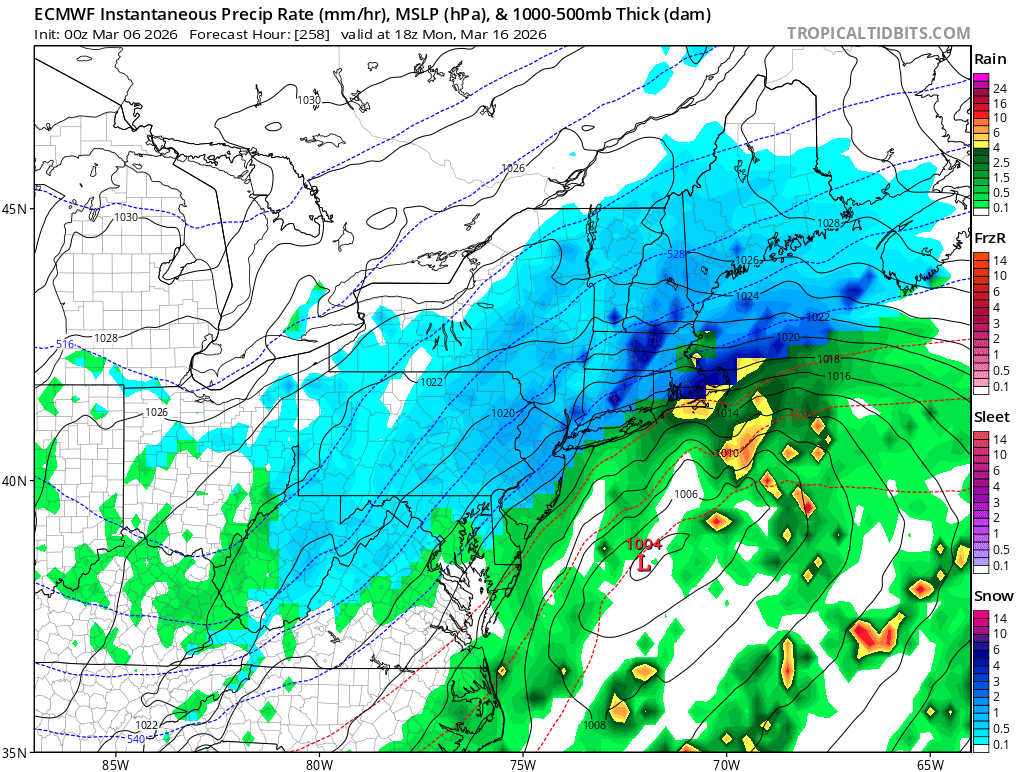
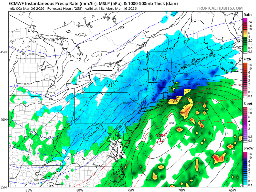
It was called a 100 year storm so unlikely to see again in our lifetime if they are correct. The arctic cold was extreme for March even back then. As long as we keep seeing snow in April we sill still get snowy March months.
-
The craziest part of that month was NYC received a 4.4 inch snowstorm in a sea of warmth
-
I think the record for this date was 77 in 2016. Can we break?
-
Close on February 21 2018 it hit 78 (old record was 68 in 1930 which stood for 88 years!!!!)
-
When will we break this one: "The earliest in the year that New York City had a high temperature of at least 80 °F is March 13 which happened in 1990."
-
Not saying winter is over. We still have another window. However add another myth debunked to the list: Debunked: We no longer see benchmark storm tracks. Added to the following Debunked myths: Western pacific ocean temps mean constant MJO 456 phases. NAO always connecting to the SE ridge. Ocean temps mean the SE ridge is unstoppable. Fast flow is now unstoppable. Clippers are extinct.
-
February, but in a sea of warmth we had a snowstorm. I mean 60s and 70s and it snowed. It all has to do with intensity, track and cold air. Basically all the normal ingredients we just lose some light snow during daytime ability.
-
In keeping with the 1970s comparison; 1.) NYC hit 70+ three times in March of 1977: March 10: 70 March 29: 78 March 30: 75 March 31 close with 69 2.) NYC hit 80+ three times in April 1977: April 12: 85 April 13: 85 April 22: 83 Can we get as warm as 1977? Would be nice for a change.
-
Even it its 1 day all we need is a snowstorm to get NYC to 50 and Providence to the all time record. A long window would not even matter that late in the season.
-
Way out there but this next window is the last to: 1.) Get CPK to 50 inches 2.) Give Providence their all time snowiest winter!!!! Unlikely given that March only had 5 inches or more when December had the same FOUR TIMES since 1970.
-
This is interesting. Only 4 winters starting with 1970 through last year had over 5 inches of snow in both December and March.
-
Not recent, and the 2nd year was only 29.4 barely above average, however you can include 77/78 and 78/79 (77/78 also had 2 KUs, one of which mixed with sleet like this year and the other a bomb cyclone like this year).
-
Yeah the effected population is off the charts and definitely more of an impact than the blizzard. It is odd that they have not released it yet.
-