WhiteoutWX
-
Posts
892 -
Joined
-
Last visited
Content Type
Profiles
Blogs
Forums
American Weather
Media Demo
Store
Gallery
Everything posted by WhiteoutWX
-
That jives with my estimate based on a 3 hour averaged motion from radar. Will have to see if the forecasted eastward turn occurs before or after landfall as that could shift it south. I have no idea how well the HRRR usually performs with near term TC tracks, but the 18z run takes the center right to the mouth of Tampa Bay.
-
Definitely a more NNE heading the last couple hours from looping the radar mosaic. Could easily wobble more eastward again though. Several models show an eastward turn right before landfall as well. Timing of that turn is going to be so crucial for Tampa in regards to surge.
-
 Might have spoken too soon. Stuff really getting going central OK near the warm front.
 -
Warm front is evident on Frederick radar in SW OK. Nearly stationary. Think that area east of Lubbock and whatever develops on the warm front will be the main show. Clearly the cells that were near Amarillo early are north of the boundary and the stuff the HRRR was blowing up in central OK is likely just the usual HRRR shenanigans where it takes warm advection showers and creates a cluster of supercells. Seems way overdone there at this point, though I guess something could still get going across south central OK where better surface heating is occurring.
-
Agree that Monday definitely has some higher end potential. Similar to Friday the best forcing with the wave will be in Kansas. Right now I’d say south central Kansas/north-central OK and eastward along the warm front present the best chance for initiation and tornado threat. I’m much more skeptical we see initiation further south into central Oklahoma given the track of the wave and residual capping, but not out of the realm of possibilities we could get a storm to go, which if it did would also be in a concerning environment.
-
“Cap” and “conditional” are quickly becoming the words of the 2022 severe season.
-
MO/KS/AR/OK 2021-2022 Winter Discussion
WhiteoutWX replied to JoMo's topic in Central/Western States
Major disagreements between the models on precip amounts for the Wednesday-Thursday timeframe, especially for TX/OK. This one seems to have a lot less agreement among the models than the past few systems from this range. I think the goalposts are still basically anywhere between mainly dry cold front to major winter storm for these areas. Further east it seems the precipitation amounts are a little less sensitive to the trough orientation so I’d be feeling better sitting in AR and MO. Cold air is definitely not in question at the surface but the warm nose aloft seems especially strong this go around. Looks like mainly sleet and/or freezing rain for those that do see precipitation. -
MO/KS/AR/OK 2021-2022 Winter Discussion
WhiteoutWX replied to JoMo's topic in Central/Western States
18z GFS colder and a little southeast for Wednesday. Pretty much lost the Thursday afternoon and evening portion of the storm for Oklahoma and parts of Texas as it opened the upper wave quicker and it gets strung out. Hoping that changes back. -
MO/KS/AR/OK 2021-2022 Winter Discussion
WhiteoutWX replied to JoMo's topic in Central/Western States
^^ Why it's hard to trust the NAM past 48 hours. It's prone to large run to run swings. -
MO/KS/AR/OK 2021-2022 Winter Discussion
WhiteoutWX replied to JoMo's topic in Central/Western States
The NAM is the outlier for now and is out on the later end of its range still. GFS/Canadian have so far been the most consistent models and have also been the coldest. Euro somewhere in the middle. That said, can’t ignore the number of times warm noses have been underestimated at this range. We’ll see what 12z brings. -
MO/KS/AR/OK 2021-2022 Winter Discussion
WhiteoutWX replied to JoMo's topic in Central/Western States
I’d say 18z GFS is likely about the ceiling for this event. Would definitely be a major storm for much of this sub -
MO/KS/AR/OK 2021-2022 Winter Discussion
WhiteoutWX replied to JoMo's topic in Central/Western States
Euro is more positive tilt and flatter with the wave than the other models. Hence the further southeast solution -
MO/KS/AR/OK 2021-2022 Winter Discussion
WhiteoutWX replied to JoMo's topic in Central/Western States
It’s a precarious setup as far as the precip amounts go. Cold air seems all but guaranteed for most, but getting the precipitation far enough north and west is all coming down to how quickly the trough can dig and sharpen to our west and become more neutral tilt as opposed to the more positive tilt models had been showing. Also at play are multiple individual short waves rounding the base of the trough that may lead to multiple rounds. Right now models are kind of bouncing around on how these short waves interact. To be expected at this range. But also expect more changes as we get closer. This one has room to dig even more and become a truly significant storm, but it could also head the other direction and most of the precipitation stays south of the cold air and we just get some very cold temps. I’m not buying any individual solution right now. -
Southern Plains Winter 2021-2022
WhiteoutWX replied to Iceresistance's topic in Central/Western States
Pretty much most run the last few months -
Couple quick points watching from afar: 1. No one should be using the global models (GFS/Euro/Canadian etc.) from this point forward for surface temps and dew points. The hi-res models will do a much better job of handling the shallow cold airmass associated with the CAD. The HRRR, NAM, and other hi-res variations are what people should be paying attention to. 2. From experience growing up in this area and having been through many winter storms, the warm nose almost always overperforms, and I’d say the synoptic setup with the upper low passing overhead or to the west only argues for that scenario even more. Expect mostly sleet or freezing rain outside the mountains, and even there I wouldn’t be surprised if mixing occurs at times. 3. As far as impacts go, there is a HUGE difference between freezing rain at 32 degrees and freezing rain at 30 and below. This has me concerned for the I-85 corridor near Charlotte where temps will be below 30 for the majority of the precipitation. The biggest limiting factor will be precipitation rates as heavy freezing rain does not accrete as efficiently as a light to moderate rainfall. Most of the precipitation should fall quick and fast in a 6-10 hour window, which may help limit max accretion potential. Still, a I think there will be a swath of 0.5-0.75” of accretion somewhere near the Charlotte area when all is said and done.
-
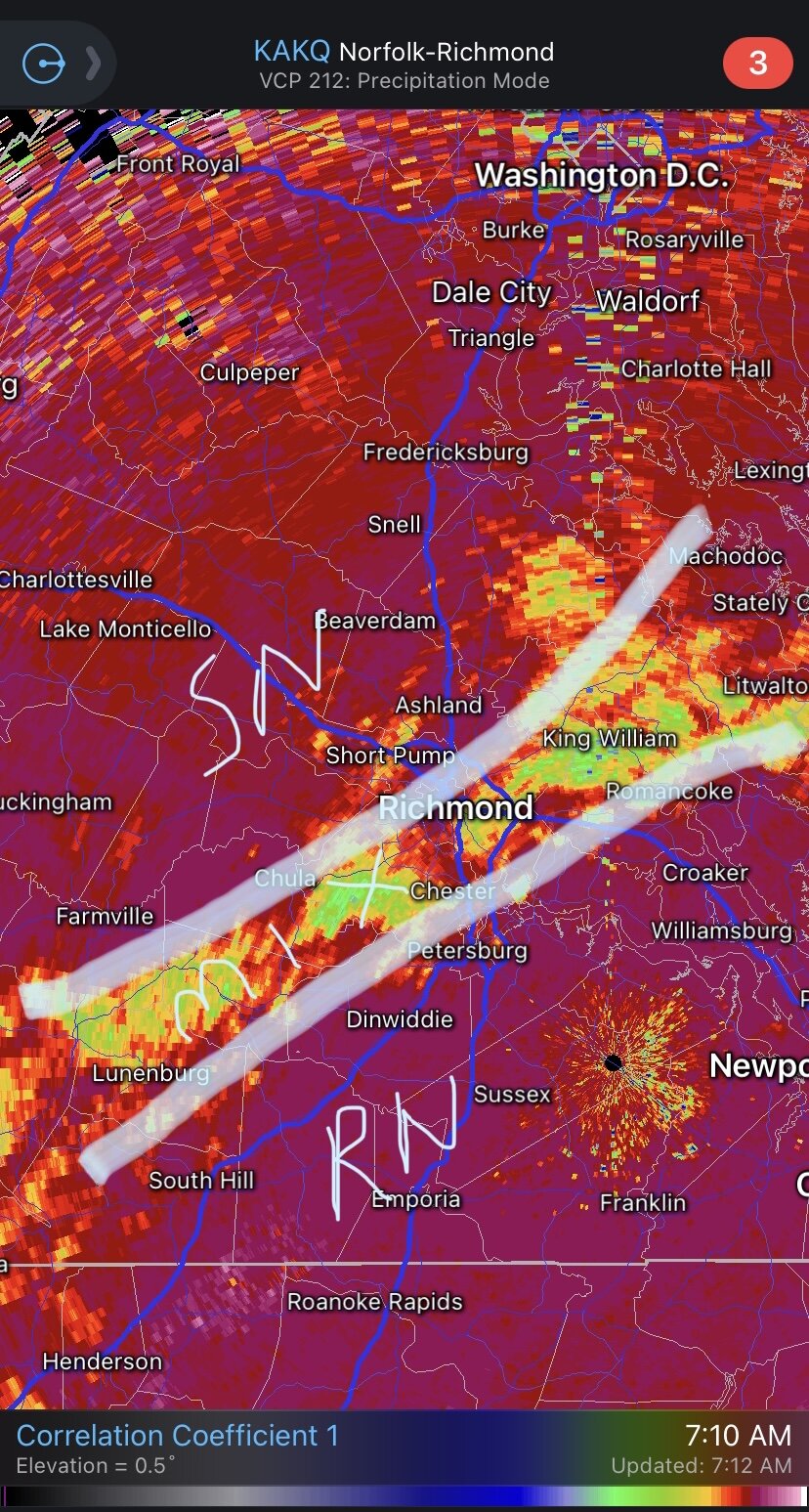
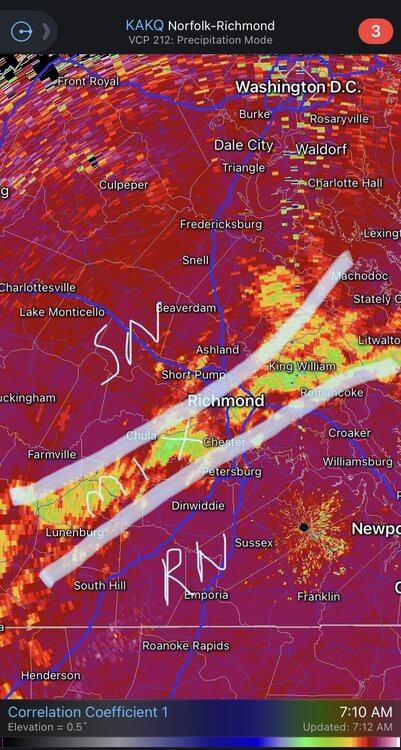
Transition line showing up clearly on correlation coefficient. Slowly working south and east now.
-
This thing clearly has not made a turn north yet. Good news for New Orleans.
-
Maybe a bit of a westward jog last 30 minutes? I think NOLA proper dodges the brunt of the eyewall at this point. Maybe western sides of town get scraped by it. They need every westward wobble they can get though.
-
This system has been on the right side of the short term guidance envelope for days. I’m not super surprised.
-
I don’t remember how models did with Rita but they’ve been tightly clustered on a landfall location with this one the last day or so. I think track confidence is fairly high at this point. Margin for error is still probably big enough for New Orleans to miss out on the worst of it, but still seems prudent in this case to give people more time to evacuate than wait for a last second scramble when it’s too late, especially given the potential for a major upon landfall.
-
Biggest limiting factor for a high end cane right now is mainly the time over the gulf. Most models are only showing about a 36 hour window now between exiting Cuba and landfall in Louisiana. The more eastern solution has also led to a faster solution.
-
I would think with a developing system this type of lopsided appearance would bias the storm track slightly to the east as convection continually fires on the eastern semicircle and pulls the low level center that direction.
-
2021 Atlantic Hurricane season
WhiteoutWX replied to StormchaserChuck!'s topic in Tropical Headquarters
The Euro appeared to end up further north and east because it consolidated energy along the northern end of the wave axis while GFS focuses development further south. The overall 500mb synoptic pattern looks very similar between both models. I think we’ll continue to see windshield wiping on the models until we get a more concrete surface center (no surprise). -
I foresee several consecutive marginal/slight risk severe days over the next week but I think clearly heavy rain/flooding seems to be the bigger story. With a closed low the shear profiles are likely to be junky and less than ideal. Mesoscale enhancements due to boundaries from previous convection may lead to a surprise tornado day in there, but overall still looks relatively unexciting as far as a large synoptic scale tornado setup.
-
And then moisture gets shunted south and we wait another week or more