
WhiteoutWX
-
Posts
892 -
Joined
-
Last visited
Content Type
Profiles
Blogs
Forums
American Weather
Media Demo
Store
Gallery
Everything posted by WhiteoutWX
-
 Man I forgot how awesome that Dodge City storm was. It was just tornado after tornado is mostly wide open fields with a decent road network. I don't think I'll ever top that one.
 -
The 850 flow is pretty much nil across NW Texas today I would be surprised if we see any tornadoes there today. I would play south and hope for some Del Rio magic.
-
Could do without the hysterical screeching
-
Central/Western Medium-Long Range Discussion
WhiteoutWX replied to andyhb's topic in Central/Western States
We haven’t even hit May yet. Still plenty of season left. -
The slower/deeper progression has really evolved this towards more of a run of the mill type severe event in my opinion. The flow becomes more meridional which is not only causing much messier hodographs but is also leading to weaker lapse rates (hence the lack of instability on some of the models). The end result is likely to be messier storm modes. The “classic” dry line/tornadic supercell look the Euro was advertising from before really hasn’t been there for a few days now. The flooding threat may end up the bigger story out of this.
-
MO/KS/AR/OK 2020-2021 "Winter" Discussion
WhiteoutWX replied to JoMo's topic in Central/Western States
Just focusing on central Oklahoma the 00z NAM/HRRR and 21z RAP were very nice and have all come in with higher snow totals and a longer duration, lingering light snow well into Wednesday afternoon. Again it will likely come down to a narrow band where snow totals end up being close to double areas to the north and south. -
MO/KS/AR/OK 2020-2021 "Winter" Discussion
WhiteoutWX replied to JoMo's topic in Central/Western States
12z Euro/GFS really backing off on snow totals for tomorrow/Wednesday storm. Hi-res models are generally higher, but disagree on exact location on heavier band. I think this one will end up with a much more narrow area of good snows compared to yesterday/today. I think most should expect 2-4", with isolated 6-8" possible if the hi-res models are right with a heavier band. -
MO/KS/AR/OK 2020-2021 "Winter" Discussion
WhiteoutWX replied to JoMo's topic in Central/Western States
Still moderate to heavy snow in Norman. Been like this since about 1 today. Radar seems to be filling in some to the SW. I think we could definitely reach the 8-10” forecast here. -
MO/KS/AR/OK 2020-2021 "Winter" Discussion
WhiteoutWX replied to JoMo's topic in Central/Western States
I’m not sure really. It has a deeper and more neutrally tilted wave which helps precipitation blossom further west and is also a bit slower. Ive noticed the euro has had a bit of a NW bias all season though so it may be a bit off. -
MO/KS/AR/OK 2020-2021 "Winter" Discussion
WhiteoutWX replied to JoMo's topic in Central/Western States
Euro looks so much different than every other model for NW OK and the panhandles. It’s been very persistent about the max snowfall being mostly west of 35, all the other models are SE of there. -
MO/KS/AR/OK 2020-2021 "Winter" Discussion
WhiteoutWX replied to JoMo's topic in Central/Western States
It's actually been very consistent overall today as far as I can tell for much of SW MO, S Kansas, central and western OK. Maybe a slight decrease but still way more than any other model. The area of greatest variability has been over Arkansas and north Texas. I'd still call it a win to see it mostly hold in the face of some of the drier CAMs. Let's see if they start to come on board more as we get more in range. -
MO/KS/AR/OK 2020-2021 "Winter" Discussion
WhiteoutWX replied to JoMo's topic in Central/Western States
Euro looking juicy again for much of central and western OK through 00z Sunday. Continues to be slower and deeper with the wave than the other models. Overall very similar to 18z. Max QPF totals central and western OK. -
MO/KS/AR/OK 2020-2021 "Winter" Discussion
WhiteoutWX replied to JoMo's topic in Central/Western States
It's not the great look we were seeing yesterday with widespread > 0.5" totals, but I feel it at least stopped the bleeding. -
MO/KS/AR/OK 2020-2021 "Winter" Discussion
WhiteoutWX replied to JoMo's topic in Central/Western States
Overall 00z GFS looks very similar to 18z, if not slightly better. Definitely not a drying trend. -
MO/KS/AR/OK 2020-2021 "Winter" Discussion
WhiteoutWX replied to JoMo's topic in Central/Western States
While the CAMS are a little worrying for many (dry), let's wait for the 00z GFS and Euro before panicking. The CAMs may still be a bit out of their best range right now. -
MO/KS/AR/OK 2020-2021 "Winter" Discussion
WhiteoutWX replied to JoMo's topic in Central/Western States
GFS ensemble has clearly be trending southward the past 4 runs, with 12z continuing the trend. Looking a little dry in southern Kansas and SW MO now. -
MO/KS/AR/OK 2020-2021 "Winter" Discussion
WhiteoutWX replied to JoMo's topic in Central/Western States
00z GEM more expansive with precip than 12z, but QPF totals still much less than GFS/Euro. Still, a step in the right direction. -
MO/KS/AR/OK 2020-2021 "Winter" Discussion
WhiteoutWX replied to JoMo's topic in Central/Western States
I would trust the GFS/Euro and their ensembles still at this range. Could the NAM be right? Sure. Is it the most likely solution in the face of all the other model data right now? Not really. I will say that its solution is the way I have been worried we fail for the past couple days. It keys in more on the lead wave and doesn’t get it out of the way in time. The other models ride the knifes edge and just barely keep the lead wave weak enough for the trailing wave to amplify and take on a more neutral to negative tilt. Again, the NAM is unlikely to be right at this range, but I will be watch the trends on the other models regarding the lead wave very closely. That’s the key IMO. -
MO/KS/AR/OK 2020-2021 "Winter" Discussion
WhiteoutWX replied to JoMo's topic in Central/Western States
Central OK will be the big winner this run -
MO/KS/AR/OK 2020-2021 "Winter" Discussion
WhiteoutWX replied to JoMo's topic in Central/Western States
6z GFS less snow for those east of 35. It weakens the shortwave and ends up flatter. Looks like the GEFS is not as bad but does cut QPF some for eastern OK, NW AR, southern MO. -
MO/KS/AR/OK 2020-2021 "Winter" Discussion
WhiteoutWX replied to JoMo's topic in Central/Western States
Winds will likely be 20-30, gusts to 40 across much of Oklahoma and Kansas, maybe a bit less further east. -
MO/KS/AR/OK 2020-2021 "Winter" Discussion
WhiteoutWX replied to JoMo's topic in Central/Western States
It’s good but I prefer 12 or 18z for central Oklahoma. I don’t like the north shift and the more SW-NE axis of heaviest snow on this one. Really screws over our north Texas friends. One more shift like that and OKC-Tulsa would be on the edge of the good stuff. Still an amazing run but the jog north is a little concerning still being 4 days out. I’m sure you guys in Kansas loved this one though. We’ll see what the ensembles say. -
MO/KS/AR/OK 2020-2021 "Winter" Discussion
WhiteoutWX replied to JoMo's topic in Central/Western States
I’d basically just go with whatever the coldest model output is for the next several days (and even then might not be cold enough). Remains to be seen how the weekend plays out but still strong signals for some more extreme cold by Saturday/Sunday. -
MO/KS/AR/OK 2020-2021 "Winter" Discussion
WhiteoutWX replied to JoMo's topic in Central/Western States
This is what the HRRR had for its forecast for our current temperatures from 24 hours ago. Huge huge HUGE bust and this is a hi-res model from short range. Models almost always underdo the southward extent of arctic air masses and are too quick to try to mix them out. Keep this in mind for the next couple days.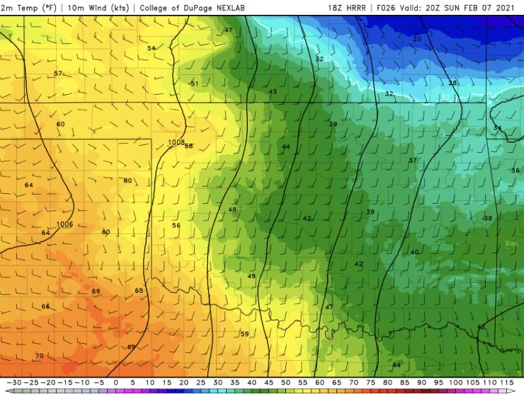
-
MO/KS/AR/OK 2020-2021 "Winter" Discussion
WhiteoutWX replied to JoMo's topic in Central/Western States
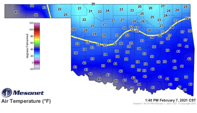
NAM depiction seems reasonable with shallow cold wedge holding firm and overrunning from 925-850mb layer leading to occasional freezing drizzle. I think the Euro is way off on it’s temps, especially Tuesday with clouds and light precipitation and the ridge pressing southward. Wednesday remains to be seen, it depends on how much clearing we get after the subtle shortwave passes by. GFS may be a little too cold at this point but it’s been extremely consistent for days now so not gonna totally discount it.

