Random Chaos
-
Posts
902 -
Joined
-
Last visited
Content Type
Profiles
Blogs
Forums
American Weather
Media Demo
Store
Gallery
Everything posted by Random Chaos
-
Play-by-play: Latest GFS run has ticked slightly south at hr 138. Commentary: remember the early model runs of Maria took her into the Chesapeake Bay? Completely missed way south ended up recurving into the backside of Florida. So long range is almost useless to hang onto edit: this is my post # 666. Wonder if that bodes ill?
-
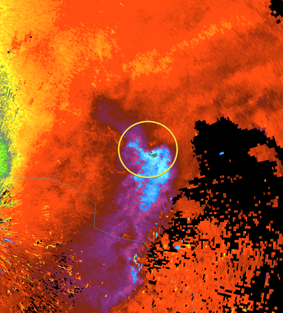
Eye looks worse on KTLH radar than on KVAX radar. I think we are getting some radar occlusion from that intense convection in the NW eyewall.
-
There was an eyewall dropsonde before NHC said 100mph that measured 98kt winds at 955mb (less than 1000 ft above surface). Suspect that’s what they used. There is now a new dropsonde with 110kt winds about 1700ft above surface (921mb):
-
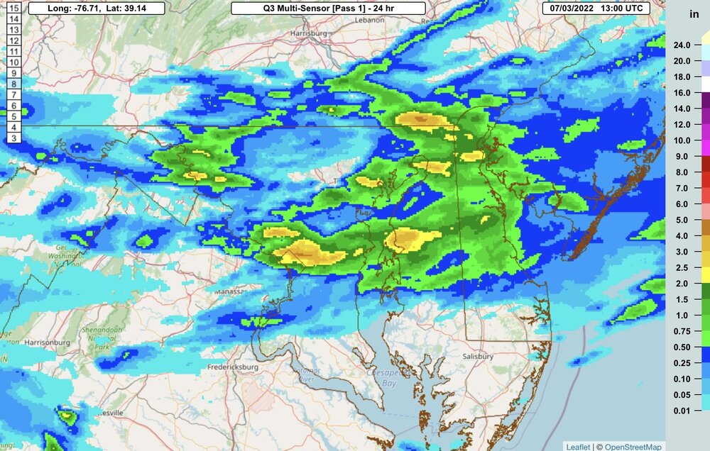
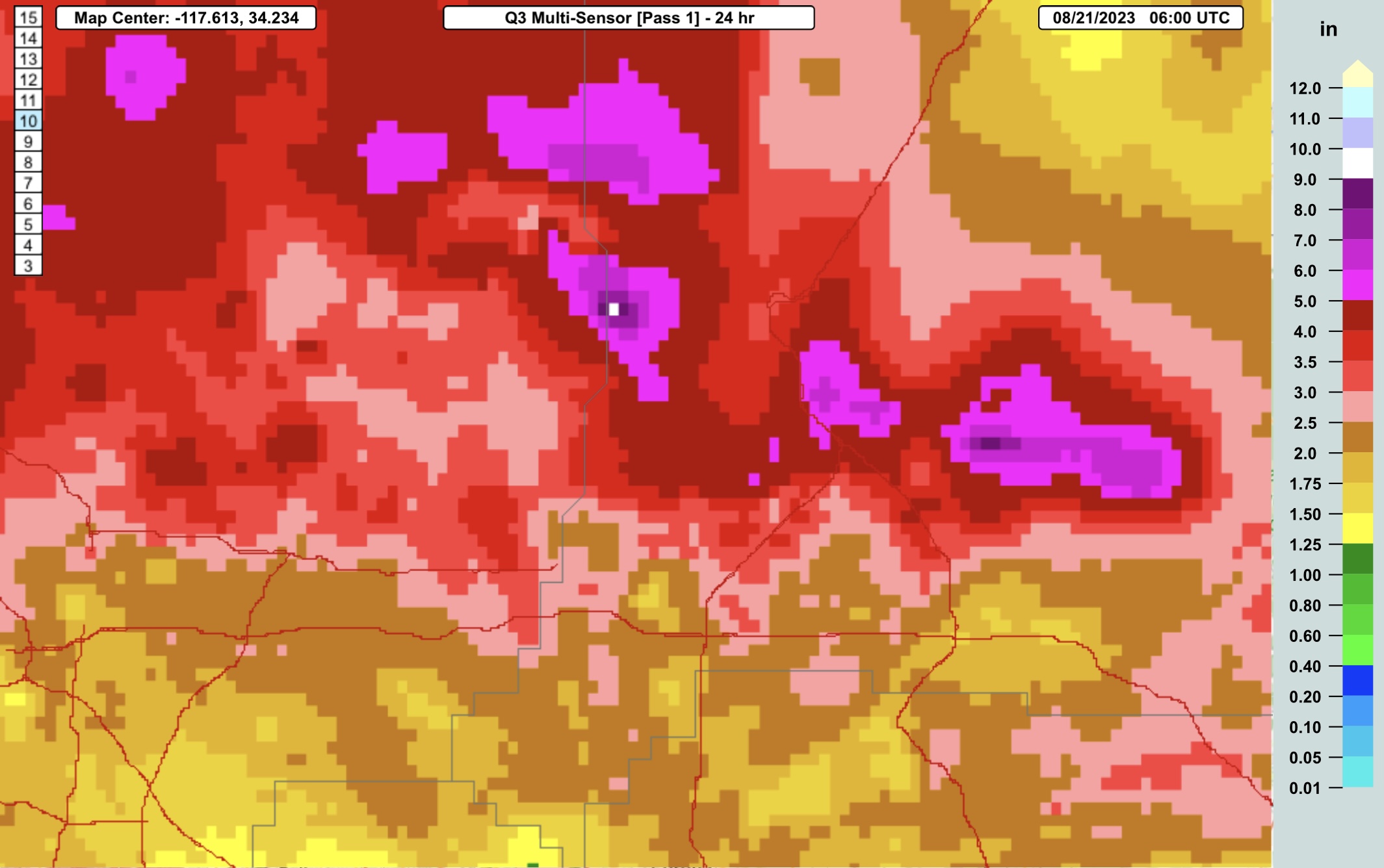
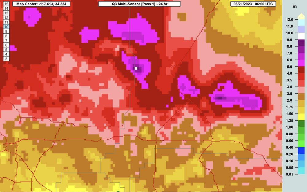
Some insane totals estimated in the mountains north of LA: https://mrms.nssl.noaa.gov/qvs/product_viewer/ - Q3 Multisensor, 24 hr:
-

2023 Mid-Atlantic Severe Wx Thread (General Discussion)
Random Chaos replied to Kmlwx's topic in Mid Atlantic
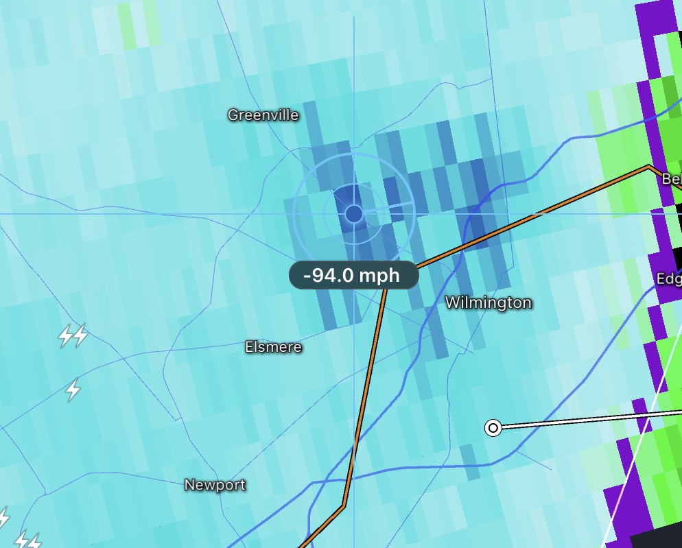
Wonder what Wilmington got. Saw some 94mph readings on KDIX radar as it passed over there.
-
2023 Mid-Atlantic Severe Wx Thread (General Discussion)
Random Chaos replied to Kmlwx's topic in Mid Atlantic
Moderate rain, 40mph wind peak. Happy to miss the worst of this line, still a while to go before the rain is done. The heavy winds moved just north of me basred on KLWX and KDOX radar. Power did flicker which caused my anemometer to stop reading at 40mph until I reset the receiver (never had that happen before), but I didn’t feel like the wind got much faster. -
2023 Mid-Atlantic Severe Wx Thread (General Discussion)
Random Chaos replied to Kmlwx's topic in Mid Atlantic
As the storm approached: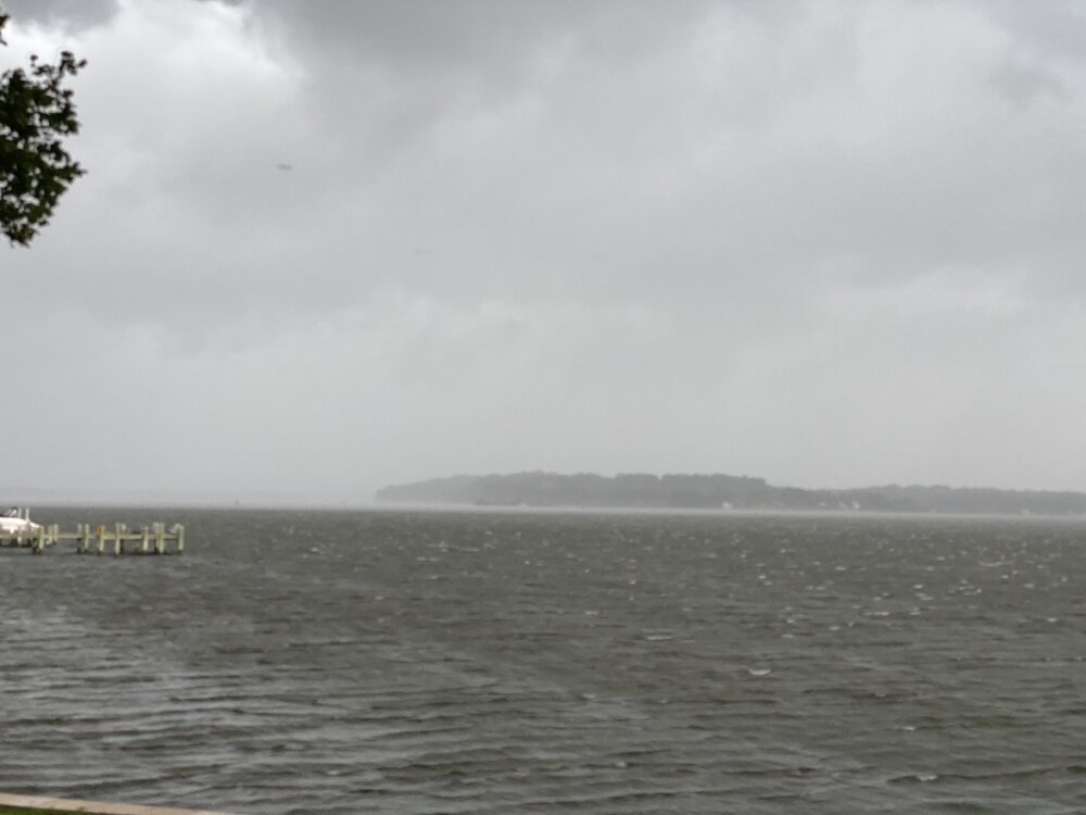
- 2,785 replies
-
- 10
-

-
- severe
- thunderstorms
- (and 3 more)
-
2023 Mid-Atlantic Severe Wx Thread (General Discussion)
Random Chaos replied to Kmlwx's topic in Mid Atlantic
Anne Arundel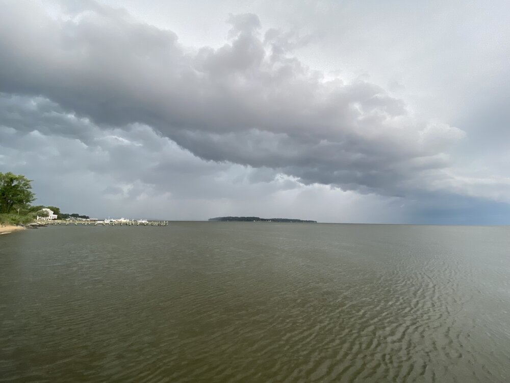
- 2,785 replies
-
- 9
-
-
- severe
- thunderstorms
- (and 3 more)
-
2023 Mid-Atlantic Severe Wx Thread (General Discussion)
Random Chaos replied to Kmlwx's topic in Mid Atlantic
The hodographs look wild on the 3k NAM.- 2,785 replies
-
- 1
-
-
- severe
- thunderstorms
- (and 3 more)
-
2023 Mid-Atlantic Severe Wx Thread (General Discussion)
Random Chaos replied to Kmlwx's topic in Mid Atlantic
-
2023 Mid-Atlantic Severe Wx Thread (General Discussion)
Random Chaos replied to Kmlwx's topic in Mid Atlantic
- 2,785 replies
-
- 1
-
-
- severe
- thunderstorms
- (and 3 more)
-
2023 Mid-Atlantic Severe Wx Thread (General Discussion)
Random Chaos replied to Kmlwx's topic in Mid Atlantic
Tornado warning now for that cell. -
2023 Mid-Atlantic Severe Wx Thread (General Discussion)
Random Chaos replied to Kmlwx's topic in Mid Atlantic
I was looking at current radar vs current models and HRRR, FV3, and NAM3K aren’t picking up what is currently on radar while HRDPS is. -
2023 Mid-Atlantic Severe Wx Thread (General Discussion)
Random Chaos replied to Kmlwx's topic in Mid Atlantic
To this day I still feel NWS under-graded that tornado. They called it a long track EF0, but my parents property appeared to have around 90mph EF1 damage. I know NWS never visited that location on the track. The official assessment talked about downtown Rockville and Sping Valley locations mostly, and ignored west Rockville where the damage was mostly wooded residential and park areas. One house up the street from my parents had 7 mid-sized trees land on it, shifting the house on it’s foundation but luckily only doing minor roof damage; they were able to repair it in a few months. One thing clear from the photos my parents sent me was that it was a tornado: the 30" diameter oak was uprooted such that the tree fell to the right but the pivot point was above the rootball with the rootball to the left of the hole it came out of. Straight line winds would have it pivot from then forward edge of the rootball, and instead the entire rootball shifted about 8-10 feet left of that point, indicating the tree was lifted partially out of the ground then pushed over. -
2023 Mid-Atlantic Severe Wx Thread (General Discussion)
Random Chaos replied to Kmlwx's topic in Mid Atlantic
That’s the storm that dropped a tornado on my parent’s back yard, taking down 2 30"+ diameter trees parallel to their house and topping another 30" diameter tree. June 13, 2013:
- 2,785 replies
-
- 3
-
-
- severe
- thunderstorms
- (and 3 more)
-
2023 Mid-Atlantic Severe Wx Thread (General Discussion)
Random Chaos replied to Kmlwx's topic in Mid Atlantic
Not quite hitting severe where I am. 40mph 5.8"/hr rain is the peak so far. Zero visibility it’s coming down so fast. Already got 0.30" rain and am about half way through. -
December 22-23, 2022: Warm Rain to Arctic Chill
Random Chaos replied to WxUSAF's topic in Mid Atlantic
Just switched to snow here. 39F and dropping fast. -
December 22-23, 2022: Warm Rain to Arctic Chill
Random Chaos replied to WxUSAF's topic in Mid Atlantic
Looking at temperatures out in Ohio the HRRR is running close to correct while the NAM 3km is 5F warm. GFS is closer to HRRR than NAM but hard to tell specifics with only 3 hour data. Brrrrr. -
I flickered outside Annapolis at the exact same time the plane crashed too. Definitely some brief widespread grid disruption from this. They haven’t started rhe rescue yet - still getting equipment and crews in position - would not be surprised if the plane is still in the tower come morning.
-
2022 Mid-Atlantic Severe Wx Thread (General Discussion Etc)
Random Chaos replied to Kmlwx's topic in Mid Atlantic
Downburst at up to 90mph in College Park. Nothing for Olney yet. --- PUBLIC INFORMATION STATEMENT NATIONAL WEATHER SERVICE BALTIMORE MD/WASHINGTON DC 153 PM EDT WED JUL 13 2022 ...STORM DAMAGE SURVEY RESULTS FROM COLLEGE PARK IN PRINCE GEORGE'S COUNTY MARYLAND... TODAY, STAFF FROM THE NATIONAL WEATHER SERVICE BALTIMORE/WASHINGTON WEATHER FORECAST OFFICE CONDUCTED A STORM SURVEY IN THE CITY OF COLLEGE PARK IN PRINCE GEORGE'S COUNTY MARYLAND. THE SURVEY IS IN RESPONSE TO THE SEVERE THUNDERSTORM THAT MOVED THROUGH THE AREA BETWEEN 600-610 PM EDT ON TUESDAY JULY 12 2022. THERE WAS EXTENSIVE DAMAGE IN THE CITY OF COLLEGE PARK, WITH MANY TREES SNAPPED AND UPROOTED. SOME TREES FELL INTO RESIDENCES, PRODUCING STRUCTURAL DAMAGE. PEAK WIND GUSTS WERE ESTIMATED AT 80-90 MPH. OBSERVATIONS FROM THE SURVEY SHOWED THAT THE DEBRIS FELL GENERALLY TOWARDS THE EAST, PRODUCING A DOWNBURST PATTERN. THESE OBSERVATIONS, COUPLED WITH VELOCITY IMAGES FROM THE FAA'S TERMINAL DOPPLER WEATHER RADAR AT BWI THURGOOD MARSHALL AIRPORT WHICH MEASURED 85 MPH WINDS AT APPROXIMATELY 1000 FEET ABOVE GROUND LEVEL, ALONG WITH VELOCITY PRODUCTS FROM THE NWS KLWX WSR- 88D IN STERLING VA, CORROBORATE THAT THE MOST LIKELY CAUSE OF STORM DAMAGE IN COLLEGE PARK WAS STRAIGHT-LINE WINDS EMANATING FROM A SEVERE THUNDERSTORM. STRAIGHT LINE WINDS FROM THUNDERSTORMS CAN PRODUCE TORNADO-LIKE DAMAGE. YESTERDAY EVENING'S ESTIMATED WINDS IN COLLEGE PARK ARE EQUIVALENT TO THAT OF A LOW-END EF1 TORNADO. THE NATIONAL WEATHER SERVICE THANKS THE CITY OF COLLEGE PARK DEPARTMENT OF PUBLIC WORKS IN ASSISTING WITH THE STORM SURVEY. -
2022 Mid-Atlantic Severe Wx Thread (General Discussion Etc)
Random Chaos replied to Kmlwx's topic in Mid Atlantic
0.56" in my gauge yesterday. After it was over, beautiful sunset.
-
2022 Mid-Atlantic Severe Wx Thread (General Discussion Etc)
Random Chaos replied to Kmlwx's topic in Mid Atlantic
I managed no real wind, just a lot if rain. Storm barely missed me south. -
2022 Mid-Atlantic Severe Wx Thread (General Discussion Etc)
Random Chaos replied to Kmlwx's topic in Mid Atlantic
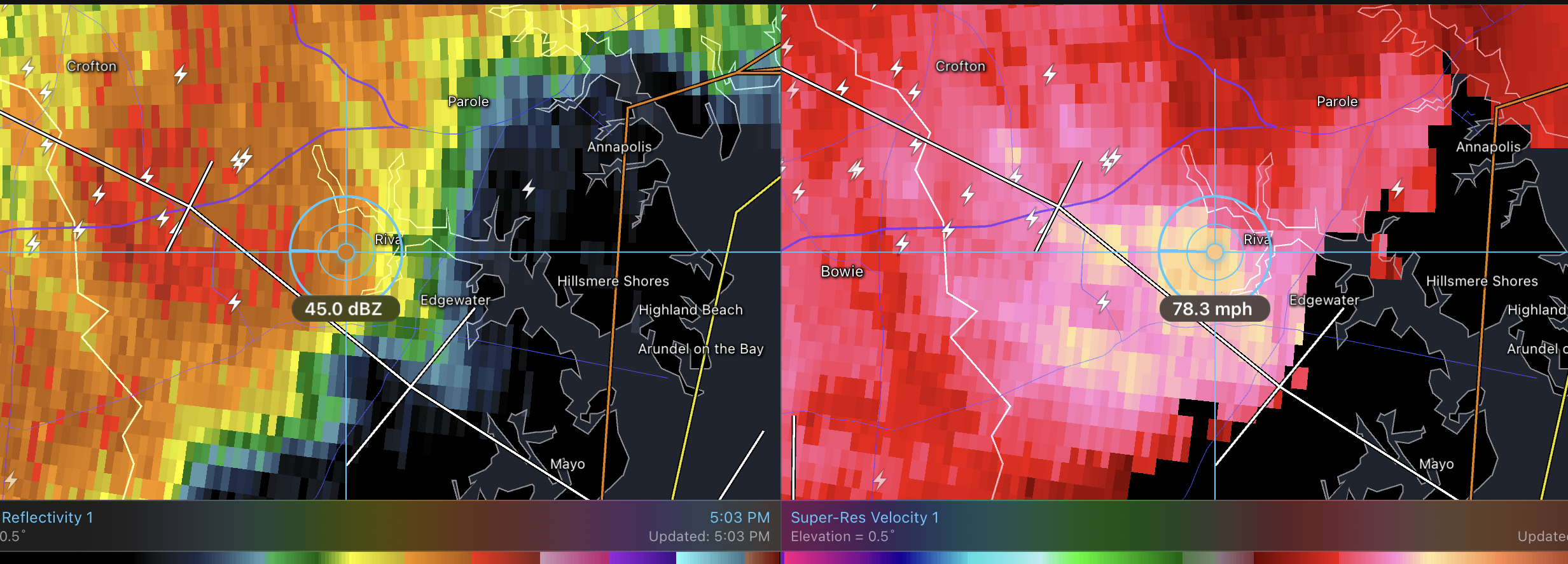
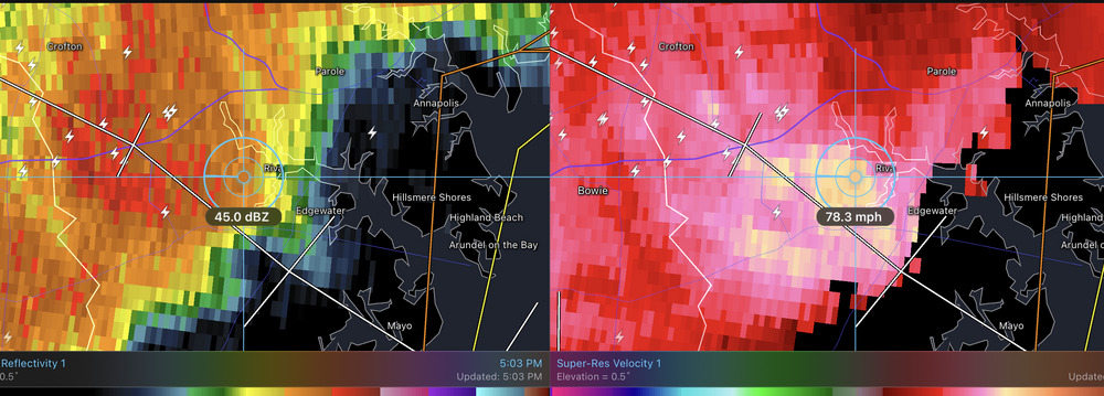
Looks like a broad area circulation over Annapolis, and now a tvs signature from Dover radar per radarscope image. -
My rain guage shows 0.76", but that’s way low. First storm only registered 0.04" due to the wind driving the heavy rain straight sideways and not filling the tipping guage. Any suggestions on how to measure storms where the rain simply doesn’t go into the guage’s cone? 2nd storm dumped 0.64" and seemed to rain less than the first storm (but also less windy).
-
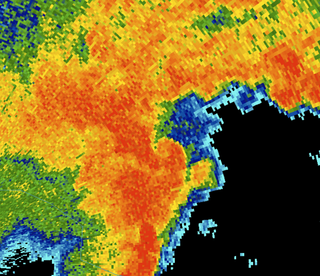
Here’s what NWS multisensor estimates: