Chinook
-
Posts
11,160 -
Joined
-
Last visited
Content Type
Profiles
Blogs
Forums
American Weather
Media Demo
Store
Gallery
Everything posted by Chinook
-
Levi's Tropical Tidbits videos are back!
-
 Now JTWC has analyzed this to be 135 knots, which I believe is just below Cat-5 on the Saffir-Simpson scale. Today's HWRF (12z) showed up to 130 knots at 850mb as it approaches an island close to the coast that has mountains that could feel the 130 knots.
 -
Web site for composite radar in the Caribbean area https://www.barbadosweather.org/BMS_Radar_Composite_Resp.php#
-
Here is a non-tropical storm with hurricane force winds and impressively low pressures (for any time of year) to impact Aleutian Islands, and areas up to Nome. (Forecast for Nome has winds of 45mph gusting to 70mph) this storm previously had been Typhoon Merbok but transitioned to extratropical at about the time shown here:
-
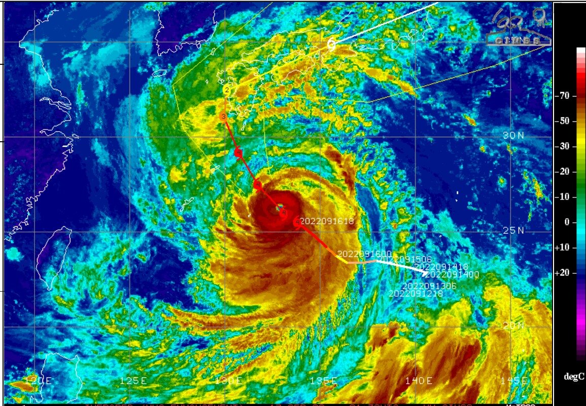
Super Typhoon Nanmadol, at 130 knots, per JTWC, will max out at 135 knots soon. It will approach Japan as it weakens some.
-
beautiful morning view
-
For what it's worth, Reed Timmer has been streaming about Fiona for the last 24 minutes. I wonder what happened to Tropical Tidbits videos?
-
Typhoon Muifa is heading directly into Shanghai China soon. Typhoon Muifa, 85 knots, as per JTWC most recent analysis. Wikipedia: With a population of 24.89 million as of 2021, Shanghai is the most populous urban area in China with 39,300,000 inhabitants living in the Shanghai metropolitan area
-
A couple of the places I used to live got 0.76" to 0.78" for the September so far, including most from the last two days. Friday was about 59.6 at Fort Collins and Saturday was 53.9. I guess that's a little lower than 100.
-
surface to 700mb stacked low pressure storm report: 3.99" of rain at Oak Creek, Wisconsin. Yikes!
-
Hurricane Kay--EPAC Magic w/ Potential Impact on Southern CA
Chinook replied to WxWatcher007's topic in Tropical Headquarters
I'm amazed. The weather always finds a way to do new things. Radar based rainfall estimation shows over 3.5" to maybe even 8.5" of rain on the east slopes of the coastal range east of Tijuana. -
Earl had some sort of a disruption (Eyewall replacement cycle?) as it passed closest Bermuda at roughly 03z. Bermuda's airport had wind gusts up to 41 knots. Now, the eye has undergone some changes. At the time of this image, it looks like the eye is a heart-shape last night NHC discussion new discussion
-
Closer to the -Rocky- Mountains, the much-needed cold front is moving in to central Wyoming right now with cooler temperatures, rain showers, and north winds with gusts over 30 knots at Douglas and 20 knots at Casper.
-
Here's a tropical storm that's near a mountain... Tropical Storm Kay, HREF maximum precipitation of the model ensemble is up to 5"-7" east of San Diego if I read this correctly
-
Hurricane Kay--EPAC Magic w/ Potential Impact on Southern CA
Chinook replied to WxWatcher007's topic in Tropical Headquarters
HWRF model version of Kay (6 hour forecast). The NHC has this at 75 knots/85 mph -
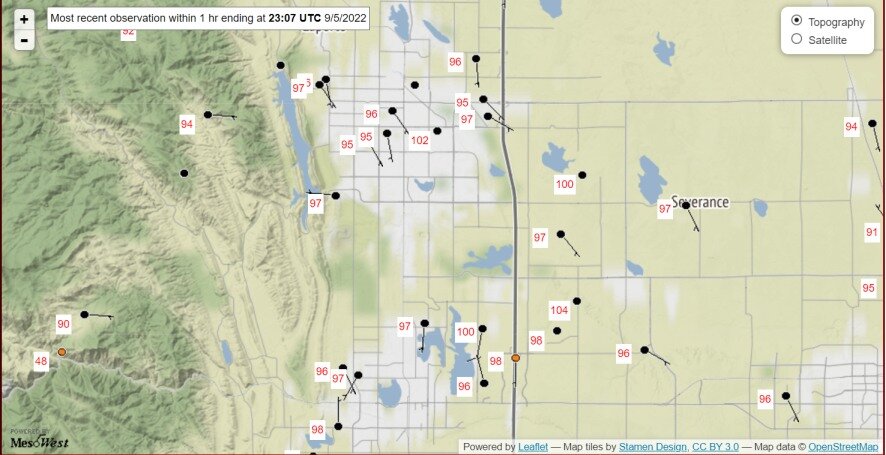
It's up to 102 degrees in Fort Collins with one local observation. Sheesh, is this September or July 4th?
-
this is 6:20am for them. The eye of the storm has been close to Busan, now with winds shifting to the north-northwest.
-
Wind gusts at Busan, South Korea, bumped up to minimal hurricane force, 64 knots RKPK 051900Z 11035G64KT 1600 +RA BR SCT010 BKN020 OVC030 27/25 Q0979 RKPK 051800Z 11037G47KT 3200 +RA BR SCT010 BKN020 OVC030 27/25 Q0984
-
This is the only time I've been able to use Korean radar (available through the US Military bases, I believe) to track a typhoon. Typhoon Hinnamnor has tracked right by Jeju Island, South Korea, close to the forecasts. JTWC had the intensity at 100 knots at a time of 12z. west Jeju Island: RKPM 051348Z 36042G063KT 3200 -RA BR BKN005 BKN080 25/24 A2871 RMK CIG005RKPM 051027Z 10036G067KT 3200 RA BR OVC010 25/24 A2896 RMK CIG010
-
some breezes in the US Virgin Islands. The radar loop shows weak rotation in the northeast sector shown here.
-
The JTWC latest update says 95 knots in the vicinity of Busan. That does sound quite bad. Also, consider Korea is pretty far north and does not get too many tropical cyclones.
-
Typhoon Hinnamnor regained 85 knot strength and an eye showed up recently on infrafred imagery When Typhoon Hinnamnor approaches South Korea, it might be interesting to use GRLevel3/ Radarscope to view these two radar locations in South Korea.
-
KFTG radar is working again after mechanical systems upgrades.
-
Fort Collins had the 2nd warmest August on record, that is, 73.8, degrees, and it slightly beats August 2020, at 73.5 degrees. It wasn't very rainy at Fort Collins or Loveland. If I had been in Loveland, the nearest CoCoRAHS would have been 0.67" of rain. Denver had the 3rd warmest August, 76.1 degrees, which was cooler than August 2020 and August 2011, both 77.0 degrees. 1.45" of rain. areas of south Denver: 2.19" of rain At the place I'm at now in Ohio, it dumped rain several times in the month of August. In fact, I just saw 7.5x as much rain as I would have seen in Loveland. There's not a hint of brown grass. The 75 dew points have gone away, and, of course, there was not a record-setting warm or cold temperature at all. On a side note, Toledo got to a dew point of 76 on two non-consecutive days in August, that ties for the highest dew point I've seen in 20+ years. I sort of saw a decent squall line on Monday. Maybe that storm system could have been classified as a derecho across Indiana. So that brings back a lot of nice memories of getting 45-50mph winds right after the air was just muggy.