Chinook
-
Posts
10,673 -
Joined
-
Last visited
Content Type
Profiles
Blogs
Forums
American Weather
Media Demo
Store
Gallery
Everything posted by Chinook
-
13z outlook for wind and tornadoes is in the moderate category, and there is a 30% hatched outlook for hail (not shown)
-
There will be a high significant tornado parameter developing after 22z, toward Duluth. It is likely that several supercells develop in western Minnesota near the low pressure. The storms may develop in a squall line but I expect the shear to he high enough force supercells to occur. The highest dew points and storm relative helicity will in the eastern half of Minnesota.
-

2022 Short/Medium Range Severe Weather Discussion
Chinook replied to Chicago Storm's topic in Lakes/Ohio Valley
This wall cloud and impressive small supercell went right by O'Hare and the Chicago suburbs. -
The town name of "Wall" might describe the situation. Areas around San Angelo got hail, baseball to softball size.
-
possible severe watch coming for mid-Texas
-
SPC upgraded the outlook today for enhanced, including Dallas, Fort Worth, Austin, and Waco.
-
Classic supercell west of Lubbock
-
Colorado Springs to the Palmer Divide probably had a lot of broken tree branches. I really don't know for sure. I think Denver got 1.20" of precipitation.
-
2022 Short/Medium Range Severe Weather Discussion
Chinook replied to Chicago Storm's topic in Lakes/Ohio Valley
possible tornado near Shelbyville IN. The best radar-detected rotation may have been at Mt. Auburn. -
I think I got less than 1" on the trees and the grass. I think I got over 0.75" on precipitation. According to the NWS, I guess my area still has "Chance Snow Showers then Slight Chance T-storms" tonight.
-
My place started getting snow at maybe 5:00 or a bit later. I think I have some decent accumulated rain of 0.40-0.65" (not sure)
-
all right. here we go. High temps on 5/19. not shown on this plot are high temps of about 86-91 in the Denver metro area. down to 42 degrees. There is a bit of drizzle
-
check out this tweet if you would like to see the full loop of this newly-released radar data from 2013
-
2022 Short/Medium Range Severe Weather Discussion
Chinook replied to Chicago Storm's topic in Lakes/Ohio Valley
This is a tornado in Illinois, very close to the radar outside of Evansville -
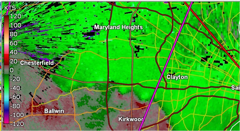
multiple areas that could be tornadoes near western Saint Louis edit: there may be tornado debris at Ladue/ Kirkwood? I have not heard any spotter reports.
-
2022 Short/Medium Range Severe Weather Discussion
Chinook replied to Chicago Storm's topic in Lakes/Ohio Valley
Today is already somewhat active with a few warnings near Evansville/Louisville and a couple in Minnesota and Missouri. SPC dropped the 10% risk for tornadoes up north and replaced it with 5% -
possibly useless fact: CIPS analog #5 (today's 12z run) has 5/31/98, which was a derecho from Wisconsin to Michigan, with severe weather reports in Ohio, Pennsylvania, New York, and Massachusetts on 6/1/98.
-
Precipitation and snow amounts nearest to me in the last few years. Annual means January to December, not some weird combo water year months or anything like that. 2012-2013: incomplete winter data, but 39.5" snow for just April-May WINTER 2013-2014 : 50.8" WINTER 2014-2015 : 38.6" WINTER 2015-2016 74.4" WINTER 2016-2017 snow 38.3" with snow-water equivalent 5.33" 2017 annual precipitation (Fort Collins): 18.05" WINTER 2017-2018: 39.9" (Fort Collins) 2018 annual precipitation (Fort Collins): 15.06" WINTER 2018-2019 44" (Loveland) 2019 annual precipitation (Loveland): 14.23" WINTER 2019-2020: 79.9" (Loveland) 2020 annual precipitation (Loveland): 13.15" WINTER 2020-2021 snow 78.8" (Loveland) 2021 annual precipitation (Loveland) 14.37" JAN 2022 18.8" snow 1.50" precipitation FEB 2022 17.6" snow 1.24" precipitation MAR 2022 0.88" precipitation, 3.1" of snow APR 2022: 0.11" rain, no snow WINTER 2021-2022: 39.5" (Loveland) (or more?)
-
5110 ft. I hope my place gets the expected value of 1" -2" of snow or less. See NWS- Boulder briefing (PDF) under the heading "SIGNIFICANT WINTER STORM TO IMPACT MUCH OF NORTH CENTRAL AND NORTHEAST COLORADO FRIDAY AND SATURDAY. FREEZING TEMPERATURES ARE EXPECTED ACROSS THE AREA SUNDAY MORNING." I kind of wish we had something like 70% chance of rain and 70 degrees, seriously. My place got thunder/lightning and 0.03" of rain on Yesterday (Tuesday). I think maybe up to 0.10" in Fort Collins. There were few other areas that got much. I saw a shower of snow hitting the top of Long's Peak, so that was cool.
-
I don't think I've ever used GRLevel2 to make a 2D vertical slice of base velocity quite like this. This is at 0323z when the bowing squall line was at Topeka. There were 75kt winds detected at some low altitudes south of Topeka.
-
I think the SPC could go with marginal or slight in Minnesota tomorrow, as you discussed. As for Thursday evening, there will be excellent severe weather parameters near the low pressure and warm front near Minneapolis and La Crosse WI. I think the SPC's day-2 discussion will be considering an enhanced risk near there.
-
Maybe the snow won't freeze the plants too bad. Let's hope.
-
I saw the lunar eclipse quite nicely as it was just a bit above the trees when it started last night, and clear skies.
-
An early day MCS, with possible severe winds and hail is likely to affect the area of some of the Missouri/Arkansas people on this board. There may be later-day development of severe storms in eastern Oklahoma update: SPC retains enhanced risk for southwest Missouri DAY 1 CONVECTIVE OUTLOOK ...THERE IS AN ENHANCED RISK OF SEVERE THUNDERSTORMS FROM SOUTHEAST KANSAS AND NORTHEAST OKLAHOMA INTO THE OZARKS...
-
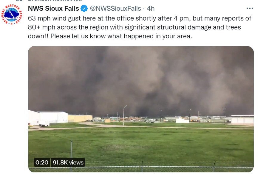
In South Dakota today, this incoming squall looks like a wall of dirt (I think it's mostly clouds and rain, maybe dirt) and then the video looks black after this. I'm sure it wasn't as black as night in reality.