
Chinook
-
Posts
10,673 -
Joined
-
Last visited
Content Type
Profiles
Blogs
Forums
American Weather
Media Demo
Store
Gallery
Everything posted by Chinook
-
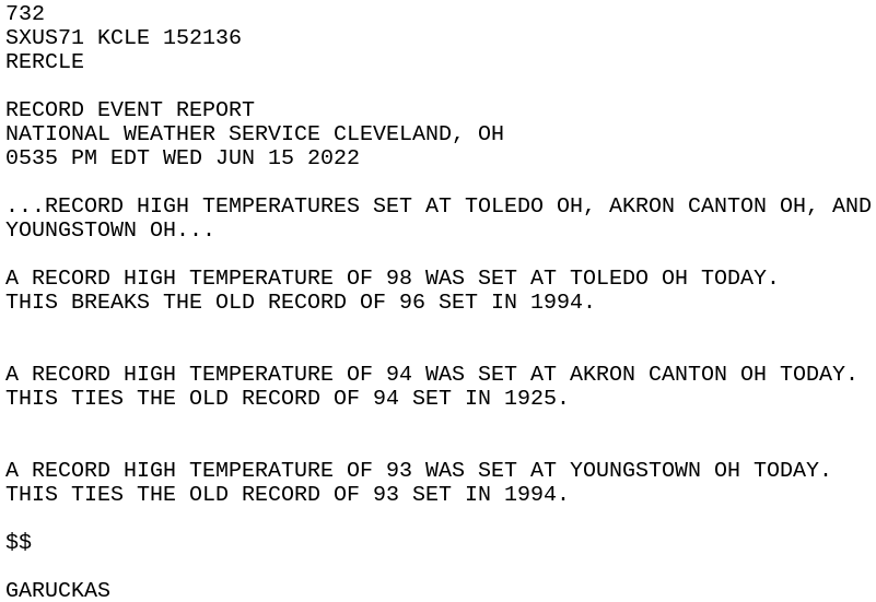
Record highs -- RECORD EVENT REPORT NATIONAL WEATHER SERVICE WILMINGTON OH 452 PM EDT TUE JUN 14 2022 ..RECORD HIGH TEMPERATURE SET AT DAYTON OH A RECORD HIGH TEMPERATURE OF 95 WAS SET AT DAYTON OH TODAY. THIS BREAKS THE OLD RECORD OF 94 SET IN 1895 --
-
If you like sports...
-

2022 Short/Medium Range Severe Weather Discussion
Chinook replied to Chicago Storm's topic in Lakes/Ohio Valley
2-d slice into the vertical for this large radar-detected wind of 80kt-90kt -
Late night tornado warning in an Iowa, not too far from Council Bluffs and Omaha
-
The cold front is coming through, now. We have had a few days of mid to upper 90's. There are much cooler temps in Utah/Wyoming at this hour. Today, the upper level winds moved some wildfire smoke from central Arizona up here and it was hazy, perhaps visibility 20 miles to the mountains. I went to the mountain pass, and obviously not enough haze to inhibit seeing nearby mountains. I felt some cool wind gusts and walked on some snow drifts. I saw several areas of burnt trees from the fire in the upper Poudre Canyon in 2020. It's nice to know that there are many trees and structures near the road that were not burnt. I am guessing a lot of the forest beyond this trailhead has burnt trees
-
There's a very broad but noticeable rotation with severe storm at the IN/MI border near Angola. This storm brought 75mph wind gusts to Sturgis MI recently.
-
3D view of the storm at 2346z while the rotation area was at Bensenville, NW of Chicago 8 minutes later
-
I've never seen a 44 value of supercell composite just west of Chicago.
-
tornado with non-supercell at DIA boundary
-
Yesterday, there were a large number of 100 temperatures in the West, including Denver. It was 99 degrees officially in Fort Collins-CSU, breaking the record of 96 degrees in 2013. The electronic thermometer hit 100.0 degrees at Fort Collins-CSU. Boulder, high 99 degrees, broke a record of 98 degrees. Limon: 97. Greeley: 96. Pueblo: 102. Colorado Springs: 96. Lamar: 103. -- 6/11: NWS Boulder: twitter: This ties for the earliest calendar day 100°F on record for Denver (also in 2013). This is our 101st 100°F reading ever recorded in Denver (since 1872). -- A RECORD HIGH TEMPERATURE OF 95 WAS SET AT CHEYENNE WYOMING AIRPORT YESTERDAY. THIS BREAKS THE OLD RECORD OF 92 SET IN 2013. A RECORD HIGH MINIMUM TEMPERATURE OF 61 WAS ALSO SET YESTERDAY. THIS BREAKS THE OLD RECORD OF 58 SET IN 1918. -- THE TEMPERATURE AT DENVER INTERNATIONAL AIRPORT HIT 100 DEGREES. THIS TIES THE RECORD HIGH TEMPERATURE FOR THIS DATE, JUNE 11TH, THAT WAS PREVIOUSLY SET IN 2013. THIS ALSO TIES THE EARLIEST IN THE CALENDER YEAR IT HAS EVER BEEN 100 DEGREES IN DENVER. THIS IS 101ST OCCURRENCE, IN DENVER, THAT THE DAILY TEMPERATURE ROSE TO 100 DEGREES OR HIGHER. OF NOTE, 55 OF THESE OCCURRENCES HAVE BEEN RECORDED IN DENVER SINCE JANUARY 1, 2000. THE DENVER CLIMATE RECORD STARTS IN 1872. -- A RECORD HIGH TEMPERATURE OF 87 WAS SET AT LARAMIE WYOMING AIRPORT YESTERDAY. THIS BREAKS THE OLD RECORD OF 86 SET IN 2013. --
-
large supercell kept a broad and sometimes intense circulation going for multiple hours as it tracked southwards
-
over a 7 mile wide rotation
-
A significant tornado debris signature southwest of Lincoln Nebraska (21:57z-22:00z)
-
Hottest Weather So Far Lies Ahead for Phoenix
Chinook replied to donsutherland1's topic in Central/Western States
high/low/average of the day June 5 102/78/90 June 6 105/79/92June 7 , high 107, missing data for low temp June 8 110/84/97 June 9 109/84/97 June 10 112/87/99.5 (technically, 100 which is the earliest 100 degree daily average temperature) -
2022 Short/Medium Range Severe Weather Discussion
Chinook replied to Chicago Storm's topic in Lakes/Ohio Valley
looks like that tornado went south of Hocking Hills state park (caves and waterfalls) that I camped at about 3 times in my life. -
2022 Short/Medium Range Severe Weather Discussion
Chinook replied to Chicago Storm's topic in Lakes/Ohio Valley
storm has a tornado (new tornado) almost right in Springfield, OH (about to hit businesses on US-68) -
2022 Short/Medium Range Severe Weather Discussion
Chinook replied to Chicago Storm's topic in Lakes/Ohio Valley
tornado on the ground near Dayton -
possible tornado with large hook echo, Las Animas Colorado area
-
3D view of the severe storm (non-tornado warned) east of the PUX radar
-
3D view of the large overhang of high reflectivity in northern Nebraska, including a rare 75dBz pixel on the base reflectivity (radar estimated 2.7" hail) And oh, by the way, 300mb winds are 100 knots over this storm.
-
The SPC has put out an enhanced risk of severe weather for the central plains tomorrow, that was the 17z outlook. Tonight's models show a large number of storms developing on the cold front in southern Nebraska. The shear could be 45 kt- 60 kt with CAPE values up to 2000 J/kg. Some supercells will form, with most likely a low storm-relative helicity and lower chance for tornadoes in most areas.
-
Today may be our first normal-looking summer day with dew points around 50 and scattered thunderstorms. My place has a dew point of 48 and there's already some lightning east of Estes Park.
-
Key West radar, some wind gusts well into the 30 mph range around Key West
-
2022 Mid-Atlantic Severe Wx Thread (General Discussion Etc)
Chinook replied to Kmlwx's topic in Mid Atlantic
local storm reports, including sub-severe reports, marine wind reports from today -
I was away on a trip. Then I came back to DIA and got my car and all this rain happened. So, not very fun driving. It was 42 degrees. Major shock. It was 90 degrees when I left DIA.

