high risk
-
Posts
3,107 -
Joined
-
Last visited
Content Type
Profiles
Blogs
Forums
American Weather
Media Demo
Store
Gallery
Everything posted by high risk
-

2022 Mid-Atlantic Severe Wx Thread (General Discussion Etc)
high risk replied to Kmlwx's topic in Mid Atlantic
Today was a total kick in the teeth. -
2022 Mid-Atlantic Severe Wx Thread (General Discussion Etc)
high risk replied to Kmlwx's topic in Mid Atlantic
Good point, but I *think* that it only affects the timing and not whether we get storms. If the line remains intact, I think it drives through the area in the early afternoon. If not, we wait for cells to fire to our west and move east during the later afternoon. None of the CAMs fail to move storms through the area at some point today, although there are admittedly disagreements in the amount of coverage. -
2022 Mid-Atlantic Severe Wx Thread (General Discussion Etc)
high risk replied to Kmlwx's topic in Mid Atlantic
I feel even better after looking at the 00Z suite, especially for those south of I-70. -
2022 Mid-Atlantic Severe Wx Thread (General Discussion Etc)
high risk replied to Kmlwx's topic in Mid Atlantic
Right, and we have respectable shear too. My concern remains, however, that several CAMs have a dying line arriving during the morning. Most of the solutions still allow us to get hot and generate new strong storms on the outflow, but the coverage isn't what I would expect to see in the setup, and we all know that this type of scenario fails here with great ease. I'm still optimistic (honestly, I just want some rain!), but it's a cautious optimism. -
I don't see an active photos thread, so I'll put it here and apologize if I screwed up, but the sky ahead of that dying line yesterday evening was glorious:

-
2022 Mid-Atlantic Severe Wx Thread (General Discussion Etc)
high risk replied to Kmlwx's topic in Mid Atlantic
Monday definitely has some really good SVR potential here. CAPE is extremely high in several models, and deep layer shear will be more than adequate. I'd say that we could get a day 2 ENH, but the timing on a few solutions might preclude that. The idea of a dying line of storms in the morning rejuvenating in the early afternoon could still work fine, but that scenario finds a way to screw us more often than it should. -
2022 Mid-Atlantic Severe Wx Thread (General Discussion Etc)
high risk replied to Kmlwx's topic in Mid Atlantic
The outflow discussed in the 6 posts right before yours. -
2022 Mid-Atlantic Severe Wx Thread (General Discussion Etc)
high risk replied to Kmlwx's topic in Mid Atlantic
Always fun to have a rogue MCS that the models can't handle. Box may be coming shortly for eastern WV and parts of northern VA. HRRR shows the line falling apart, but it has already held together much longer and stronger than the model has shown. -
2022 Mid-Atlantic Severe Wx Thread (General Discussion Etc)
high risk replied to Kmlwx's topic in Mid Atlantic
The CAMs have been pretty confident that new cells will form on the outflow and roll through Howard County. I suppose we could still fail, but I like our chances - I know that I also really need the rain and am not optimistic that the timing of the Thursday system will work out in our favor. -
2022 Mid-Atlantic Severe Wx Thread (General Discussion Etc)
high risk replied to Kmlwx's topic in Mid Atlantic
Definitely progressive, and it was correctly noted that this partially accounts for some areas that have been very wet in the past week, but there is actually some signal for several rounds of storms: In this example, you have a lead intense line, followed by a bit of a break, but then followed by another high-reflectivity area. And if you go 2 more hours, there is more redevelopment behind that second batch. Not every CAM shows this, but the HRRR scenario would definitely cause some flooding issues.
-
2022 Mid-Atlantic Severe Wx Thread (General Discussion Etc)
high risk replied to Kmlwx's topic in Mid Atlantic
Looking like an active late Monday afternoon and evening, especially for those north of DC. CAPE doesn't appear to be tremendously impressive due to weak lapse rates, and shear is marginal, but downdraft CAPE looks quite good, so it's definitely at least a MRGL day with some potential for an upgrade to SLGT. One thing that stands out on the 00Z guidance is that a lot of CAMs show multiple rounds of storms, so some flash flooding potential likely exists. -
2022 Mid-Atlantic Severe Wx Thread (General Discussion Etc)
high risk replied to Kmlwx's topic in Mid Atlantic
Yeah, the clouds at sunset had a convective look that suggested some forcing arriving, and the radar has really blown up. There were a few model runs today (12z NAM Nest stands out) that suggested that the weak front would light up a bit after dark. -
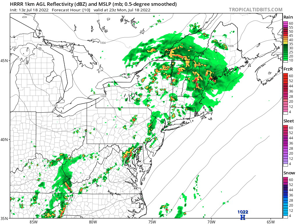
Some guidance had hinted at some convective development after sunset, and radar is now blossoming to the west.
-
2022 Mid-Atlantic Severe Wx Thread (General Discussion Etc)
high risk replied to Kmlwx's topic in Mid Atlantic
Yes! This has some potential to transition to a heavy rain event, mainly along and south of I-66. -
2022 Mid-Atlantic Severe Wx Thread (General Discussion Etc)
high risk replied to Kmlwx's topic in Mid Atlantic
He's completely accepting the details of the HRRR which has been pretty consistent in weakening that system. Not totally sure how much I'd trust that. -
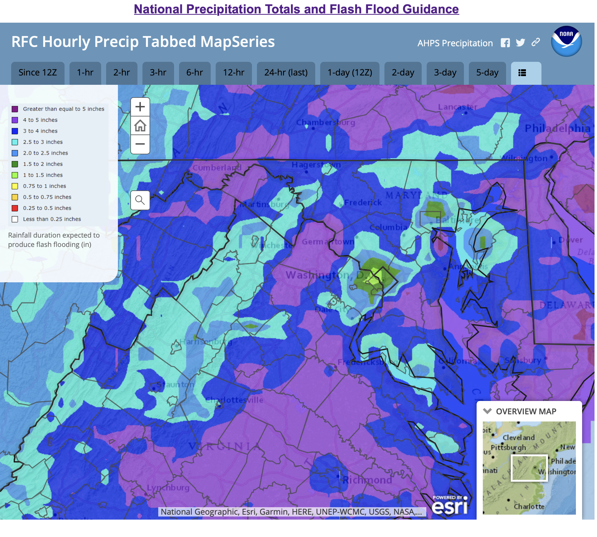
The map takes into account how much rain has fallen in recent days, and that big rain Friday night in the Arlington-Bethesda corridor has really lowered the rain totals needed to cause problems there. There will certainly be regions within the higher threat area that are far lower risk than others, but it's accounting for the general threat.
-
2022 Mid-Atlantic Severe Wx Thread (General Discussion Etc)
high risk replied to Kmlwx's topic in Mid Atlantic
As long as ongoing convection to the northwest hasn't screwed up the schedule at BWI, and no other delays occur, you *should* be ok, as no guidance has storms arriving at BWI that early. -
2022 Mid-Atlantic Severe Wx Thread (General Discussion Etc)
high risk replied to Kmlwx's topic in Mid Atlantic
Things continue to look active for the late afternoon / early evening period. SPC has added an ENH to the DC-Baltimore corridor. -
While coverage may be slightly lower in the northern counties, the main reason for leaving them out of the watch is that the flash flood guidance shows that it will take more rain up there to cause problems than it will along the I-95 corridor:

-
2022 Mid-Atlantic Severe Wx Thread (General Discussion Etc)
high risk replied to Kmlwx's topic in Mid Atlantic
As I said yesterday, I like tomorrow, especially for central MD. We'll have good timing, moderate forcing, moderate instability, and decent deep layer shear. The tornado threat isn't huge, but the forecast soundings do show some turning of direction in the lower-levels, so I would agree that a tornado or two can't be ruled out. -
2022 Mid-Atlantic Severe Wx Thread (General Discussion Etc)
high risk replied to Kmlwx's topic in Mid Atlantic
I will cautiously share some of LWX's optimism, as I kind of like what I'm seeing on the CAMs (I'll ignore the NAM Nest Howard County split....) in terms of storms forming along what appears to be the lee trough in the late afternoon Tuesday in an environment with with good instability and shear. -
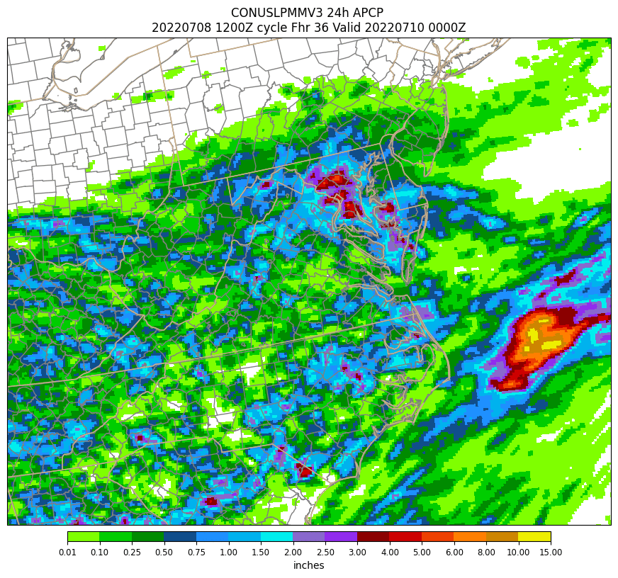
Here is the HREF 24h local probability matched-mean. For those who don't know the HREF, it's basically creating means and probabilities from existing hi-res models (NAM Nest, HRRR, and Hi-Res Windows). Impressive signal:

-
There really isn't much of a threat this evening on the east side of the Potomac (and the threat to the west doesn't ramp up until you go quite a bit further west). The heaviest rain will fall much later tonight through Saturday morning. While I am also a bit surprised that a flash flood watch hasn't yet been hoisted, the last night's guidance had a lot of disagreement on the location of the heaviest rain, so I can't blame them for waiting until there was more certainty. Looks to me like there is more agreement in the 12Z guidance that is coming out, and that watch should be hoisted by mid-afternoon at the latest.
-
2022 Mid-Atlantic Severe Wx Thread (General Discussion Etc)
high risk replied to Kmlwx's topic in Mid Atlantic
Some weak rotation and a slight hook on that cell just south of Bowie..... -
It's in development - called the Warn on Forecast System: https://wof.nssl.noaa.gov