-
Posts
3,153 -
Joined
-
Last visited
Content Type
Profiles
Blogs
Forums
American Weather
Media Demo
Store
Gallery
Everything posted by high risk
-
Well, hello HiResW FV3!
-

2026 Mid-Atlantic Severe Storm General Discussion
high risk replied to Kmlwx's topic in Mid Atlantic
Ugh. The evening CAMs have really backed off, and the NAM Nest never liked it from the start. If this idea is correct, any severe threat may be confined to along I-70 and north.- 307 replies
-
- 1
-

-
- severe
- thunderstorms
-
(and 7 more)
Tagged with:
-

2026 Mid-Atlantic Severe Storm General Discussion
high risk replied to Kmlwx's topic in Mid Atlantic
Yeah, I like the 2% hatched. It reflects that there right now is an overall low threat of tornadoes in this area, but if we were to get one, it could be a strong one.- 307 replies
-
- 2
-

-
- severe
- thunderstorms
-
(and 7 more)
Tagged with:
-

2026 Mid-Atlantic Severe Storm General Discussion
high risk replied to Kmlwx's topic in Mid Atlantic
Yeah, that was impressive. I agree that there is a lot of uncertainty, but there does seem to be some consensus that the best shot at storms and severe weather tomorrow is north of I-66 in VA and Route 50 in MD. And the real threat might be another county north.- 307 replies
-
- 1
-

-
- severe
- thunderstorms
-
(and 7 more)
Tagged with:
-
come visit us in the severe thread!
-
This makes no sense at all.
- 408 replies
-
- 13
-

-

-

-

-

2026 Mid-Atlantic Severe Storm General Discussion
high risk replied to Kmlwx's topic in Mid Atlantic
In the 00Z suite, although they differ greatly on timing and coverage every CAM other than the NAM Nest has convection in our area at some point during Wednesday afternoon in a modestly favorable environment for severe. I'd say that the initial Day 2 outlook will at a minimum keep us in a MRGL, and a SLGT isn't out of the question. The only shot at severe is with the open warm sector storms, as whatever is on the front early Thursday will be weak.- 307 replies
-
- severe
- thunderstorms
-
(and 7 more)
Tagged with:
-

2026 Mid-Atlantic Severe Storm General Discussion
high risk replied to Kmlwx's topic in Mid Atlantic
As I noted earlier, I was down on the chances, because I'm not sure what would trigger storms during peak heating. The HiResW FV3, RRFS, and ECMWF do all suggest cells in our area, however, Wednesday afternoon in an overall somewhat favorable environment, so I can't ignore that.- 307 replies
-
- 2
-

-
- severe
- thunderstorms
-
(and 7 more)
Tagged with:
-

2026 Mid-Atlantic Severe Storm General Discussion
high risk replied to Kmlwx's topic in Mid Atlantic
Soundings for later Wednesday do look interesting, but what will trigger storms? Maybe there is a subtle shortwave in the flow to do something, and the ECMWF admittedly does suggest a couple of open warm sector storms, but I'm skeptical. It appears that the strong forcing won't arrive until early Thursday, the most unfavorable time of day possible for this setup.- 307 replies
-
- 1
-

-
- severe
- thunderstorms
-
(and 7 more)
Tagged with:
-
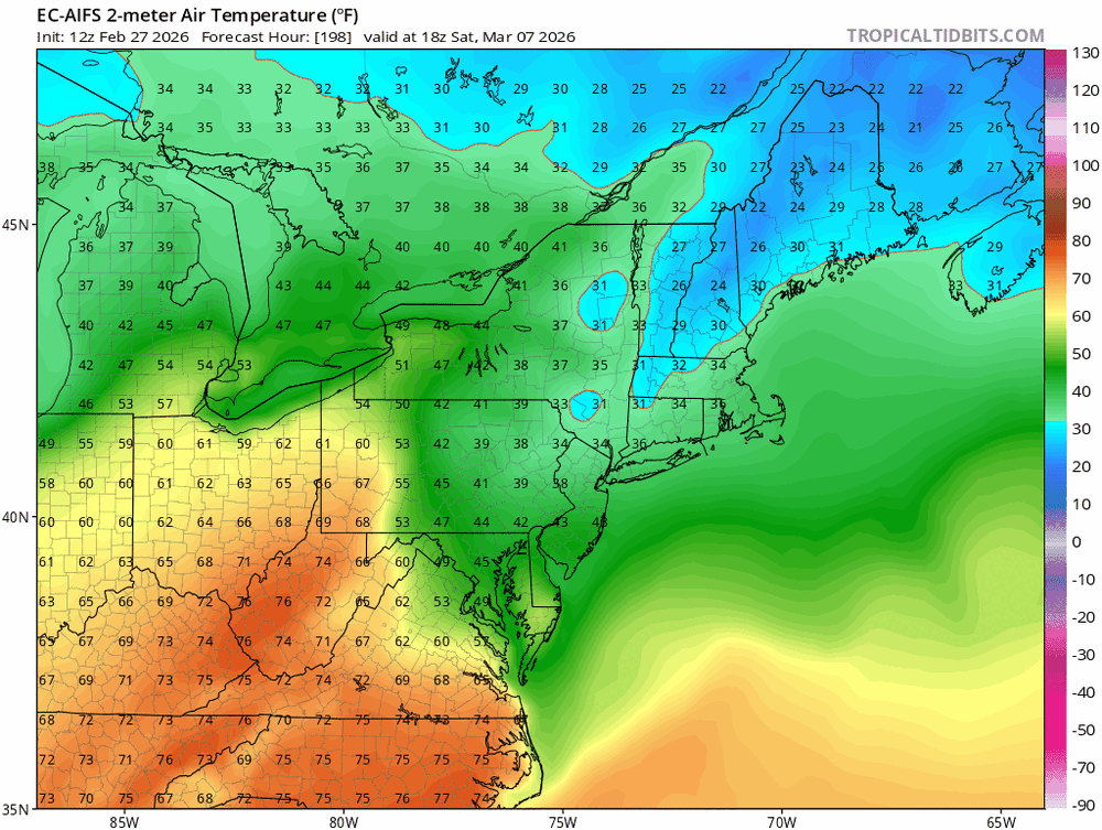
Agreed, and it's usually really good on this, but it can sometimes stay too cool if a bit of sun can break through on the cool side of the front. Regardless, it really looks like those of us on the east side of the river will get our max temp today at 11:59pm. Tomorrow could get sneaky warm ahead of the weak front sagging southward. The exact timing of the front is in question, which greatly affects the potential to get warm, but southern MD probably has the best chance of getting to the 70s.
-
If we do get some warmup east of the Potomac, it will likely be very late in the afternoon. There is a good amount of model agreement that Saturday’s max temp will occur at 11:59pm.
-
There are lightning strikes to our west, and there is good agreement in guidance for convection this evening into the overnight for at least the northern half of the region. Forecast soundings suggest enough instability for a continued threat of thunder.
-

2026 Mid-Atlantic Severe Storm General Discussion
high risk replied to Kmlwx's topic in Mid Atlantic
Way too stable for severe east of the mountains, but there will be some elevated instability, so I expect some thunder during the evening / overnight, especially for areas north of 66 (VA) and 50 (MD).- 307 replies
-
- 2
-

-
- severe
- thunderstorms
-
(and 7 more)
Tagged with:
-
Yes, completely elevated, but the forecast soundings do indicate some instability for parcels originating well above the surface.
-
Pretty good chance that at least the northern half of the area gets thunder later this evening.
-

2026 Mid-Atlantic Severe Storm General Discussion
high risk replied to Kmlwx's topic in Mid Atlantic
Nice to see the thread ready to go for the upcoming season!- 307 replies
-
- 4
-

-
- severe
- thunderstorms
-
(and 7 more)
Tagged with:
-

Outta gas and Outta Time: Early March Winter Storm finale
high risk replied to Ji's topic in Mid Atlantic
Moderate snow in downtown Silver Spring -

Outta gas and Outta Time: Early March Winter Storm finale
high risk replied to Ji's topic in Mid Atlantic
-

Outta gas and Outta Time: Early March Winter Storm finale
high risk replied to Ji's topic in Mid Atlantic
While a messy Tuesday morning rush hour has been in the cards for a while now, I'm becoming increasingly intrigued by the Monday afternoon snow event. My question is what the road temps will be like Monday after a couple of warmer days but a cold night. The NAMs and HiResW FV3 suggest that temps will only barely go above freezing tomorrow before arriving snow cools it back a few degrees. It's still tough to imagine messy roads during the daytime, but maybe if it comes down hard enough? Ultimately, it's *probably* just going to whiten grassy surfaces until you get further west and northwest, but the Monday afternoon through Tuesday morning period will be a nice reminder of winter before the big warmup. -

Outta gas and Outta Time: Early March Winter Storm finale
high risk replied to Ji's topic in Mid Atlantic
Those of us north of DC got HRRR'ed for Monday afternoon. Notable shift north for the NAMs as well..... -

Outta gas and Outta Time: Early March Winter Storm finale
high risk replied to Ji's topic in Mid Atlantic
The primary question to be resolved regards the impacts for the Tuesday morning rush hour. Monday afternoon definitely has potential for a coating of snow, and surfaces will be cold after temps fall into the 20s tonight, but I would think that daylight would mitigate road issues Monday afternoon. Models agree, however, on a batch of light-ish precip arriving later Monday night, favoring some sort of snow to sleet to freezing rain sort of progression before going to plain rain. The timing is favorable for road impacts, but guidance now suggests that it won't be as cold Monday night as initially forecasted. Would still expect at least some impacts on roads, north and northwest of the cities at a minimum. -
Beware that there are hints in the guidance, mainly in the ECMWF and its AI version, of some back door cold front action during that period.
-

Outta gas and Outta Time: Early March Winter Storm finale
high risk replied to Ji's topic in Mid Atlantic
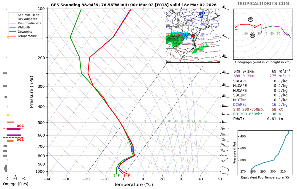
Looking over recent guidance, while the chances of a significant snow here appear to be waning, even if the Monday snow stays to our south (not entirely certain), there is some growing consensus that a modest slug of moisture will approach from the southwest late Monday night. While temperatures will be warming during Tuesday, it appears likely at this time that it will be well below freezing for the Tuesday morning rush hour, so a fairly high-impact event (even if amounts of snow or freezing rain are modest) is still on the table.- 959 replies
-
- 18
-

-

-

-

Outta gas and Outta Time: Early March Winter Storm finale
high risk replied to Ji's topic in Mid Atlantic
Verbatim, the GFS would be a messy Tuesday morning. Even as temps slowly rise, we will have had a long preceding period of temperatures below freezing. -
Great post, but you really need to check what MDL stands for.


