jbenedet
-
Posts
7,807 -
Joined
-
Last visited
Content Type
Profiles
Blogs
Forums
American Weather
Media Demo
Store
Gallery
Everything posted by jbenedet
-

1/9-1/10 Now Morphing to Less-Than-Exciting Power Cutter
jbenedet replied to Torch Tiger's topic in New England
Denial ain’t a river in Egypt. It’s gone. It’s gonna be okay. -
1/9-1/10 Now Morphing to Less-Than-Exciting Power Cutter
jbenedet replied to Torch Tiger's topic in New England
We back to brown -
1/9-1/10 Now Morphing to Less-Than-Exciting Power Cutter
jbenedet replied to Torch Tiger's topic in New England
Queen. The one behind it is the king. -
You all can put me on mute. Don't care. Your loss; not mine.
-
CT Rhode Island SE MA up to BOSTON. BUST. Most people live here. OOPS. This is trending well into ratter already for these locations; not even considering the next two cutters. Good luck @40/70 Benchmark Hopefully all these people haven't been paying attention...
-
@40/70 Benchmark: Normal to AN snowfall forecast for 2023-2024. How it's going: snowless December. One SECS in January while blizzards slam the Midwest. OOPS. "I was wrong about December" "I was wrong about January".. "I was wrong about....." Wow. Appreciate the honesty.
-
Bro get a life. Seriously. January snowfall expectations have gone DOWN even with yesterday's storm. Probability is absolutely lost on you. Even the most basic shit. I said to close the shades. You'd be much better off. I stand by it. Or we could all be holding on with great expectations following your BS, for what will be a "Don't blink, your snow is gone, January." Ratter. January is running as expected. My well below normal snowfall forecast to verify. Now you're clinging onto this storm because your January forecast and seasonal forecast is trending from worse to abysmal. You're the fool pounding your chest when January --despite this last storm--looks like dogshit against your calls. With 2 major stemwinders dumping on the midwest, and cutting the warm sector to Quebec City. Funny just a few short weeks ago you and brooklyn were celebrating those weeklies for this???? Good to know you're still standing by your shit call of Normal to AN snowfall this winter. Can't wait for the facade of accountability "I was wrong" mea culpa. And we're supposed to think this means something. Ratter odds are up; don't get it twisted.
-
“There are many ways to skin a rat” Winter 2023-2024 SNE re-analysis
-
CNE will cash in. Berks best. Still likely that area down to upstate NY, to northeast PA/extreme NW jersey Crap winter storm for the densely populated areas in New England. Lots of snow obs with little to show for it. So snow starved around here that latch onto any crap potential.
-
In all seriousness this one will be fun to watch; how much background warmth and significant El Niño conditions can muck up peak climo with a decent SLP track.
-
Nice morning out with the dog. 32/21 PSM @8:50 am +5 T departures against guidance. Who coulda seen that?
-
You’ve been tracking a crap storm potential for 10 days. We knew. Enjoy mostly white rain.
-
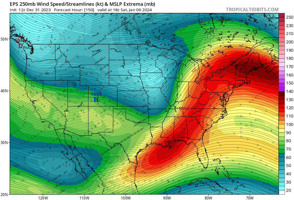
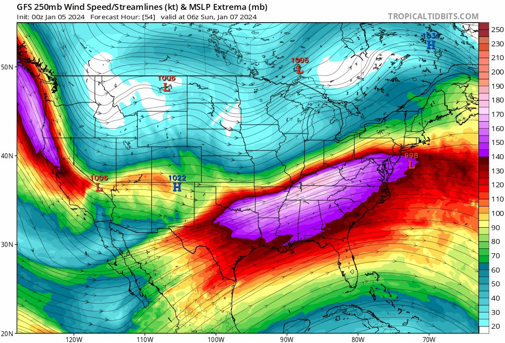
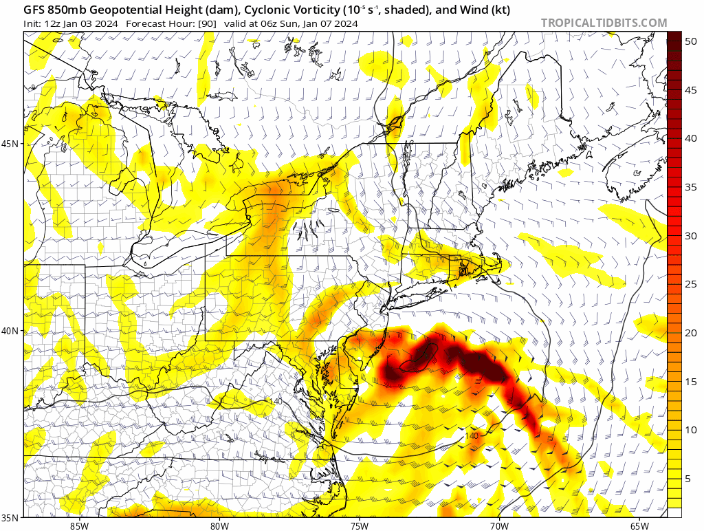
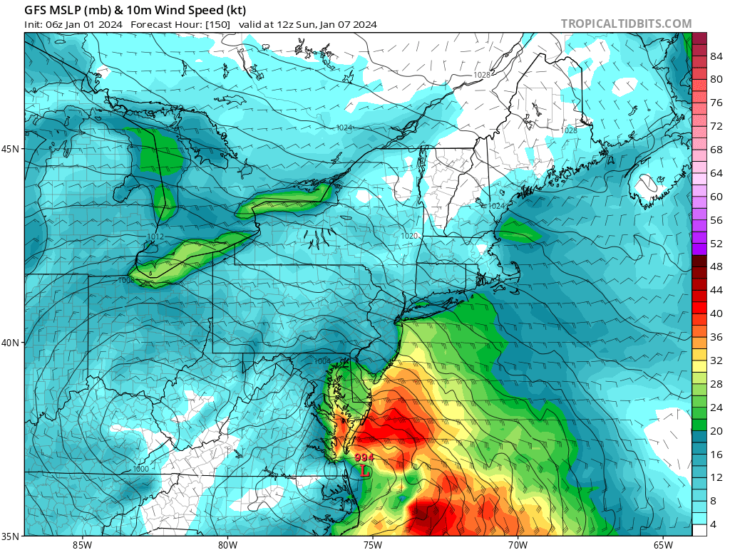
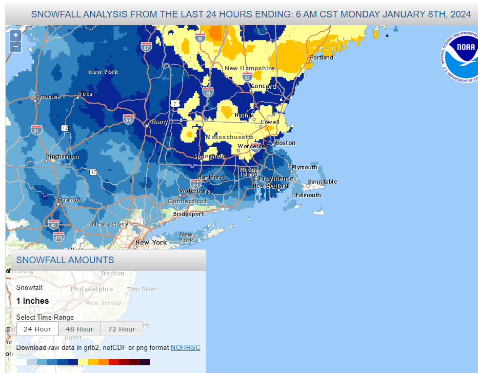
Two Mdt to high impact events NYC subforum; wknd Jan 6-7 Incl OBS, and mid week Jan 9-10 (incl OBS). Total water equiv by 00z/11 general 2", possibly 6" includes snow-ice mainly interior. RVR flood potential increases Jan 10 and beyond. Damaging wind.
jbenedet replied to wdrag's topic in New York City Metro
This is an excellent point. 850 track has been trending up and in. Very tucked.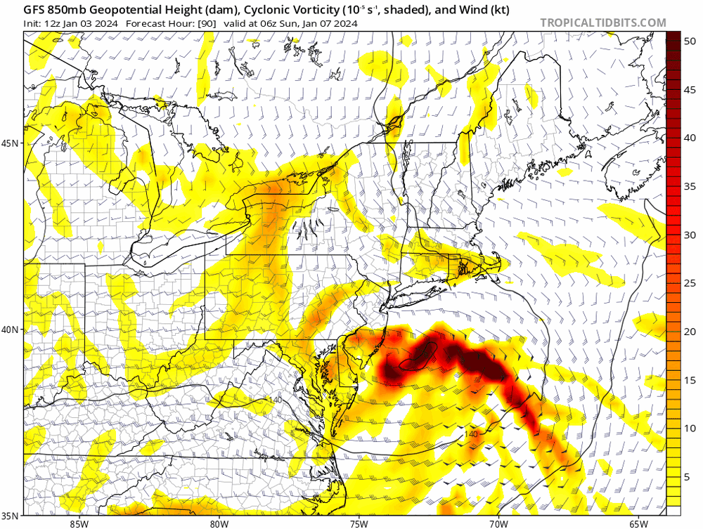
- 3,610 replies
-
- 4
-

-
- snow
- heavy rain
- (and 5 more)
-
Two Mdt to high impact events NYC subforum; wknd Jan 6-7 Incl OBS, and mid week Jan 9-10 (incl OBS). Total water equiv by 00z/11 general 2", possibly 6" includes snow-ice mainly interior. RVR flood potential increases Jan 10 and beyond. Damaging wind.
jbenedet replied to wdrag's topic in New York City Metro
H7 and H5 goes over SNE and closes off there. The surface reflection could easily end up further north/west, collocated with the H5 occlusion on that merit alone. The other aspect to further north/west track risk is the trailing shortwave is now the key player, and it is getting deeper with each run; while dampening the lead wave. The lead wave is now almost fully dissipated. Main takeaway is the evolution of this storm has changed significantly in just a day of runs; there's a lot more uncertainty (than usual) at day 3 as a result. Stronger system and tucked in is now much more likely than weak and southeast. Also with regards to timing - seems ~12 hours later as a result of the trailing shortwave being the primary feature.- 3,610 replies
-
- 2
-
-

-
- snow
- heavy rain
- (and 5 more)
-
You could use the mute option. But Nahhhhh. GFY
-
@Damage In Tolland is a child in a man's body. @40/70 Benchmark spends months analyzing in agonizing detail, but is outperformed by a 3 min read of the outside world. @ORH_wxmanWill show excitement on every storm, regardless the potential. The biggest green tag weenie, that rope-a-dopes the cohort of idiots and enables the weenie cliff-dive. A true depression driver. @WinterWolf Eats squirrels and is proud of it. Circus of rejects.
-
You guys have the mute button. Use it. But you don't...I wonder why? Circus. Echo chamber for imbeciles and terrible forecasters.
-
Two Mdt to high impact events NYC subforum; wknd Jan 6-7 Incl OBS, and mid week Jan 9-10 (incl OBS). Total water equiv by 00z/11 general 2", possibly 6" includes snow-ice mainly interior. RVR flood potential increases Jan 10 and beyond. Damaging wind.
jbenedet replied to wdrag's topic in New York City Metro
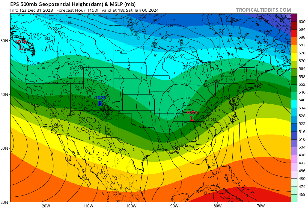
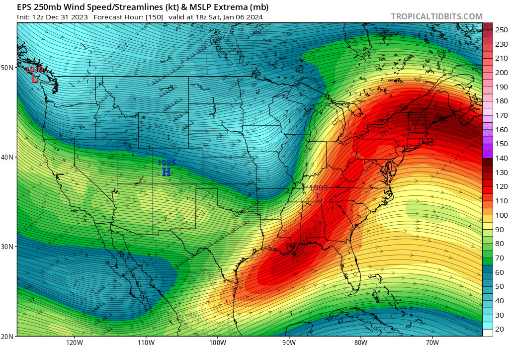
Pretty damn cool the way the pacific jet just amps up with time with such consistency. Check out the area in Northern Gulf of Mexico. Significant El Niño flexing. You see a firehouse pointed toward southeast Canada; that air coverages and sinks, filling our Canadian high with maritime tropical air. It doesn’t anchor and the depth of the cold weakens with time. It’s why a significant -NAO can get neutered with a deep trough in the west and El Niño background.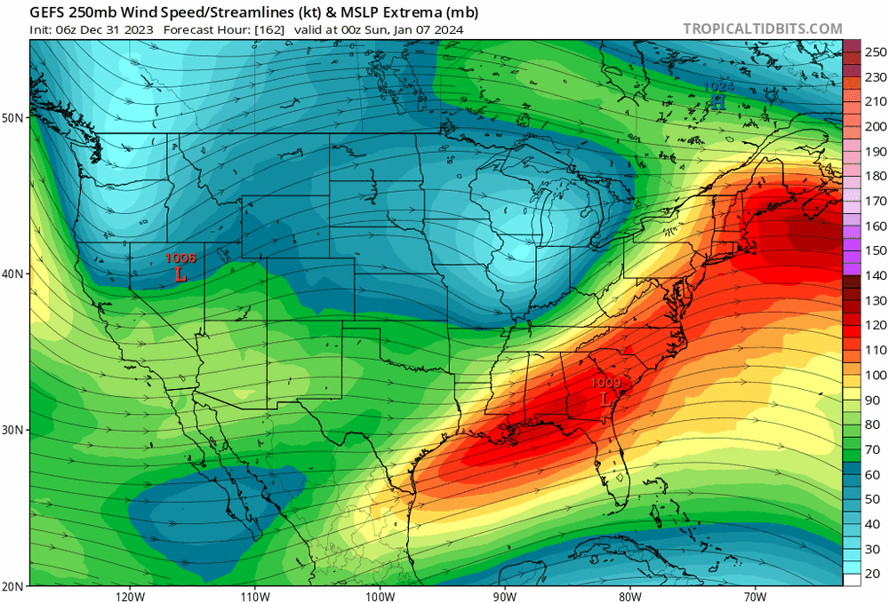
- 3,610 replies
-
- 8
-
-
-
- snow
- heavy rain
- (and 5 more)
-
Two Mdt to high impact events NYC subforum; wknd Jan 6-7 Incl OBS, and mid week Jan 9-10 (incl OBS). Total water equiv by 00z/11 general 2", possibly 6" includes snow-ice mainly interior. RVR flood potential increases Jan 10 and beyond. Damaging wind.
jbenedet replied to wdrag's topic in New York City Metro
GEFS is south. Bigger point is the way the surface high becomes one extended all the way to Bermuda. That’s a “too warm” problem for all densely populated locations along the coast. West is best.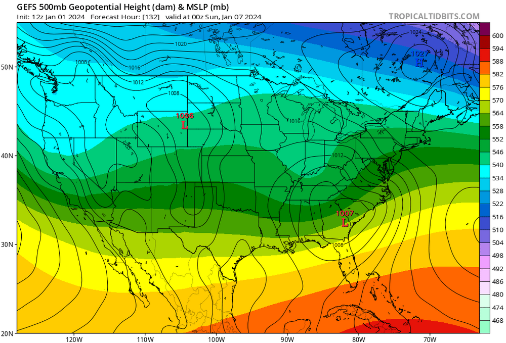
- 3,610 replies
-
- 1
-
-
- snow
- heavy rain
- (and 5 more)
-
Two Mdt to high impact events NYC subforum; wknd Jan 6-7 Incl OBS, and mid week Jan 9-10 (incl OBS). Total water equiv by 00z/11 general 2", possibly 6" includes snow-ice mainly interior. RVR flood potential increases Jan 10 and beyond. Damaging wind.
jbenedet replied to wdrag's topic in New York City Metro
I don’t look at the ICON, personally. i referenced the CMC only to see the “what if” such a scenario played out; albeit highly unlikely. I think the main takeaway is the significant snow totals look confined to a one region area, regardless of the evolution. It’s a fragile setup. -
Two Mdt to high impact events NYC subforum; wknd Jan 6-7 Incl OBS, and mid week Jan 9-10 (incl OBS). Total water equiv by 00z/11 general 2", possibly 6" includes snow-ice mainly interior. RVR flood potential increases Jan 10 and beyond. Damaging wind.
jbenedet replied to wdrag's topic in New York City Metro
Yea, this looks a lot more like a latitude capped storm—>early occlusion, with UL heights building over top of it due to trough in the pacific and then slide ENE. The 12z CMC does not make any sense to me; 12z GFS much closer to the actual evolution imo. -
Two Mdt to high impact events NYC subforum; wknd Jan 6-7 Incl OBS, and mid week Jan 9-10 (incl OBS). Total water equiv by 00z/11 general 2", possibly 6" includes snow-ice mainly interior. RVR flood potential increases Jan 10 and beyond. Damaging wind.
jbenedet replied to wdrag's topic in New York City Metro
I’m def more in the camp that this is a mid Atlantic—>south snow storm at the moment. However there will be a significant longitudinal gradient. Where H5 closes off, in and away from the coast, sees the jack. The GFS track/evolution was near perfect for a significant mid Atlantic storm but look at the east surface winds ripping. And they never orient N/Northeast, instead to ENE. The surface high in reality extends from eastern Canada to Bermuda, and therefore maintains the surface wind direction off the Atlantic. This is being flagged on the ensembles, with +surface temp anomalies. Model guidance has consistently been too cold with very short lead times this season. It’s ridiculous that GFS has LI in low mid 30’s with this wind and SST’s in upper 40’s. It’s a major issue for NYC metro. Hell even BOS will be 40F with this look.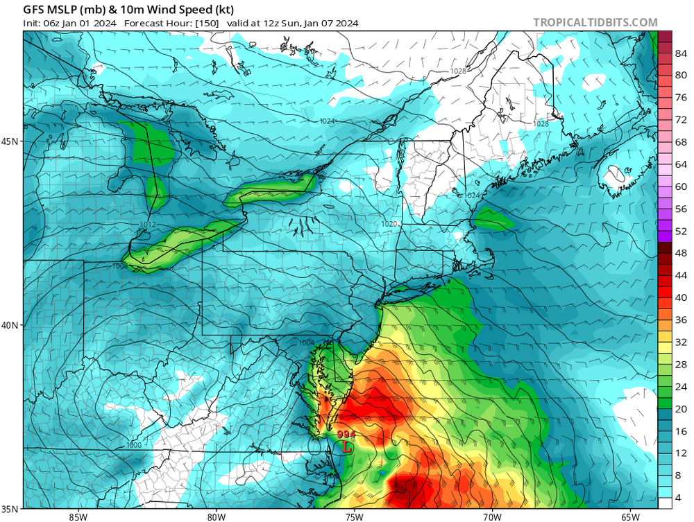
- 3,610 replies
-
- 6
-
-
-
- snow
- heavy rain
- (and 5 more)
-
There is no argument. You picked one map of two bc that fits your snow glass view. Talk to me about the EPS H5 and Pacific jet. Good luck. “See more snow” Yup. Got it.