CAPE
-
Posts
37,314 -
Joined
-
Last visited
Content Type
Profiles
Blogs
Forums
American Weather
Media Demo
Store
Gallery
Everything posted by CAPE
-
Nice blob of moderate rain here the last hour or so. Exactly a half inch so far. I was expecting a whiff, and apparently so was Mt Holly given they changed the forecast totals for overnight into this morning to a tenth or less.
-
Trying to pronounce it like an Aussie without doing the accent is a major fail.
-
Anyone who wants to watch the NFL game in Australia and doesnt have Netflix, this link works and is high quality- https://streamseast.mx/
-
AI superintelligence? We all gonna die.
-
Latest Natty Blend from tomorrow through the weekend
-
-
And no one cares about the pathetic Os going forward. Next time we will pay attention is if the owner has the nuts to fire Elias, and by extension that pathetic excuse of a manager.
-
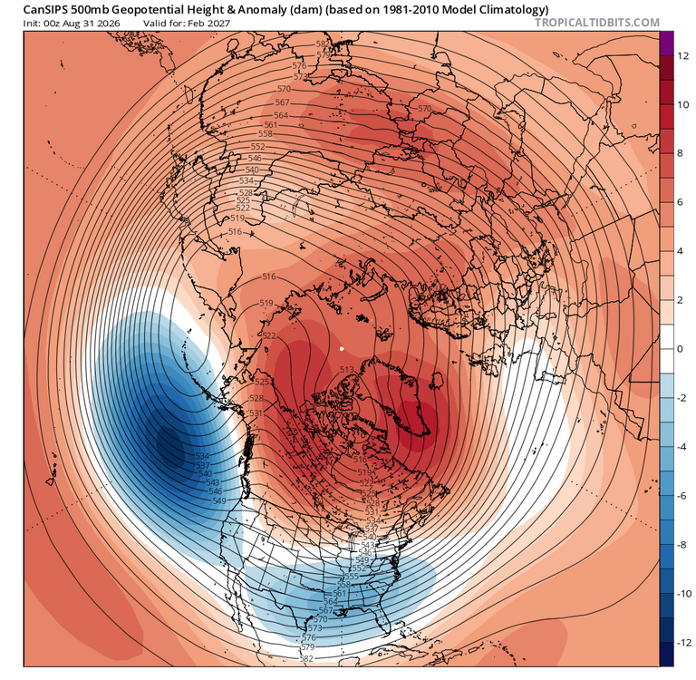
The latest CanSIPS has that feature getting stronger as winter progresses, but it also has it located far enough west for an EPO ridge. January and esp February look interesting, suggesting a -AO and -NAO as well. That combo would be a best case for cold to move southward into our nearby source region while mitigating PAC puke onslaught.
-
I'm not pessimistic, just one of several posts about the subjective nature of trying to glean details from the seasonal tools. They are all depicting the same general idea. Need the Aleutian trough to not be an eastward displaced beast all winter, and we should gets some shots of cold. Have to follow Judah to find out if the AO will be our friend.
-
here we go lol
-
Its been over for months lol. Other than hopium. Blow it up and start over. Elias the gas lighter has totally fucked this organization. Hopefully the owner is smart enough to finally see it. I have my doubts.
-
The issue is the marginal temps these models are depicting, particularly when we get a shot at a coastal storm. Normal/slightly above temps on the seasonals could be a signal for a bunch of chilly rain. The PSU perfect track rainstorms lol. We will likely need a -AO/-EPO to be present in order to overcome the onslaught of Pacific air into our source region and allow colder air to move southward. Not a prediction, but a potential fail mode, as we have seen before in strong Ninos. Location matters ofc. Interior at elevation may do ok. I root for Ninas here since the epic winter of 2009-10, as they have mostly produced avg to slightly above avg snowfall. Ninos have pretty much sucked since then.
-
Not sure if anyone posted it, but the Sept edition of the NMME is slightly warmer for DJF than the Aug run, very similar to the CanSIPS.
-
True. He is pretty solid, but coming off a serious injury. Who knows what the timetable is, thus why the guy with no NFL experience is starting.
-
Hopefully this works out well.
-
He sucks dude. Time to clean house.
-
I think you mean era, but yeah. I am sure he is happy to be a part of...this. lol.
-
-AO is key for cold down here(minus a -EPO), but in a Nino the Aleutian/NE Pac trough position/strength can mitigate the tendency to deliver colder air southward if the flow of Pac air into Canada is overwhelming.
-
Anyway, time to start worrying about the Raven's unsteady kicker, and who the hell is going to play the Center position.
-
That Cowser game saving/walk off robbing catch though!!! To get them to 500!!! The turning point!!! Haven't won since
-
79/62 Pretty nice out.
-
As depicted its a bit warmer, but it wasn't cold on last month's edition either. I think we have a pretty good idea of how this winter will go. Need a -AO and or EPO to bring some colder air close enough to work with for a time.
-
They all depict basically the same thing. Hard to parse details with these seasonal products and much of it is up for interpretation. On the new Euro Feb looks a bit more like the CFS at h5 with stronger +heights from Hudson Bay and extending eastward. Is that the result of Pac puke across Canada? Some might say its an impressive NAO block, but its a bit too far south and the height line contours are bending the wrong way.
-
I could but not going to bother lol. I am sure he will post 10 maps. Its very similar to last month but yes each winter month is a bit milder than the last run for the MA and NE. Milder across the south too. Nothing remarkably different at h5.
-
Done with the Os after the lame effort in Denver against a patsy. Told you everything you already knew. Hoping for a house cleaning, but probably won't happen. Time to focus on the King. NFL baby!