
CAPE
-
Posts
34,127 -
Joined
-
Last visited
Content Type
Profiles
Blogs
Forums
American Weather
Media Demo
Store
Gallery
Everything posted by CAPE
-
This was h5 leading up to T-day of 1989. Cold powder to right to the beaches. That was a great event for the coastal plain. 6" +. It can happen in late November.
-
T-day 1989 redux.
-
Continue to see favorable h5 looks around the 25th. Who knows if anything will come of it, and yeah lets hope we see something like this in another month or so.
-
This is pretty much my thinking. Nothing alarming at this point. Still most curious to see how the advertised NA blocking plays out. Would not be surprised if it verifies weaker than depicted, and does not persist into Dec. As I mentioned previously, I am not going to bother much with trying to glean anything meaningful from weeklies/climate/seasonal models. I will just continue to monitor the LR ens guidance daily to see how the h5 pattern is 'trending'.
-
Picked up a tenth of an inch of chilly rain overnight.
-
Mispillion and Burley Oak I am familiar with. Good stuff there. Might be looking for a new line of work in the next year or 2 if I take early retirement. I want your job.
-
He is right there with snow88.
-
Drinking a Bmore Hazy. True NE style juicy DIPA, brewed by Oliver Brewing in Baltimore. This is good stuff. I'll be getting more of this.
-
Yeah we literally just had a triple coupled PNA/EPO/WPO ridge bridge with the cold snap this week. I would say its reasonable to think we see more of that going forward.
-
The period centered on the 25th has and continues to look interesting on the GFS/GEFS. Coastal pops a bit too far north(nails SNE) this run, but that period has potential, esp given the advertised NA look.
-
Not too concerned with seeing "extreme" cold here in the near term. It rarely does us any good before mid Dec. There are some hints on the ens guidance of ridging trying to reestablish in the EPO domain, so there is that. We are all just trying to get a feel for the potential background state at this juncture, and seeing persistent troughing near the Aleutians and the lack of a SE ridge are good signs. We will see how things evolve in the HL/NA. Not seeing any indications yet of a raging +AO/NAO developing going forward.(other than most climate/ seasonal models suggesting it lol)
-
I don't think too much blocking is even remotely a concern at this point. A good start is to see if it materializes as advertised. Most likely we see a -NAO for the end of the month period. How negative it gets and how long it lasts is TBD. EPS is not as robust as the GEFS with the NA blocky look, and has been trending both the AO and NAO to neutral as we move into December. As always, we shall see.
-
Third string pounding the block.
-
Maybe rename the other thread to include November, then shut this one down. Anything short term can go in the Discobs thread. And ofc, if there is a legit threat before the end of the month, a new thread shall be created.
-
Looks like 35 is the high here. Just an awesome feeling mid winter day.
-
23
-
That was a seriously fun winter. Lots of luck involved, but hey sometimes things just go our way. The frozen inland waters and even large parts of the bay was awesome too. Love that stuff. eta- I think that was the winter that featured the epic poetry thread. lol fun times.
-
Yes a legit block and a moderate Nino combo is a great equalizer. Otherwise it's mostly a crap shoot. I don't mind a Nina because we can get plenty cold, and with the baroclinic boundary further east I can catch the edge of offshore coastals/developing Miller Bs like a couple winters ago. Chased back to back early Jan big storms at the beach, and still came home to 6" of snow that stayed around for 5-6 days both years. Ofc west of the bay it was classic cold/dry. Last winter my yard failed every way possible lol. Was uncanny.
-
Never easy or simple in this region. Often a flawed pattern ends up getting it done. That works better for you than me though lol.
-
EPS looks damn good. GEFS looks good wrt to HL/NA blocking, but trends towards lower heights out west. Not necessarily a bad thing, but I prefer the EPS look.
-
I know you know this, but looking at composites/means do not imply that the given anomaly will be there 100% of the time. Give me a general cold look imby and I will take my chances every time- If its dry, its dry. Can't snow if it's not cold enough. You clearly view things from the other end of the stick, but thats a function of our disparate climo in this region. eta- I thought you preferred a cold winter with multiple low end events (eg NS) rather than an overall mild winter with one big dog(2016). Also, good chance the atmosphere behaves more like a weak Nino than a Nina, so there should be some STJ action undercutting any ridging out west.
-
Full moon looks cool through the high clouds.
-
Yeah I pulled up some traffic cams and it doesn't look like anything is happening. Must be picking up something aloft.
-
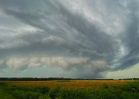
Sure looks like it. At least enhanced.
-
Radar lighting up with snow flurries/showers along the east side of the bay. Could be some flizzard conditions incoming. Currently 34. eta- looks like bay effect/bay enhanced. Developing and moving N-S along the bay.


